|
| | | |
| |
|
| Biking - Mtn | 13.44 Miles |
330 AEG |
| | Biking - Mtn | 13.44 Miles | 2 Hrs 40 Mns | | 5.04 mph |
| 330 ft AEG | | | | |
|
|
| |
| Linked |
|
none
[ show ]
| no linked trail guides |
| Partners |
|
none
[ show ]
| no partners | | Continuing on from the previous [ photoset ] Enid to Xmas Camp segment ...
Eleven years ago, BLM did not allow any motorized traffic in the area. Today, at BLM 8003, the barbed wire gate could be opened, and there were no “Closed Area” signs. There was actually an info board!
Though 10° warmer than a month ago, it was totally overcast, so it felt cooler. Initially, the sand on the road was not too deep, but I was working too hard. Instead, I rode most of the way to North Tank on the east side of the roadThe rest of the day, I biked road / trail where I could, went cross-country when I couldn’t, or pushed when I had to.
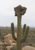
The first Mormon Battalion skull pole is 150 yds. past the North Tank corral. Apparently, there is a history sign across the road, but I missed it.
After crossing the deep sandy wash, there is a kiosk with no info at all. The road continues right to Conley Tank, while the actual trail veers left across a small wash, where there’s another skull pole. It’s not obvious, but trust me: That’s the historic route, as per topo maps. Since the roads are often squishy, I followed the historic route. Both the road and the historic route are the same distance to MM 4.
3.3 mi: Mile marker 1.0 skull pole. There is enough shrubbery that you can’t see from one marker to the next. After 35+ years, the markers’ weather aged structures blend with the desert’s natural colors. Generally speaking, if you aim at Butterfield Pass — the prominent notch in the Maricopa Mountains — you will be on track.
3.8 mi.: Fiberglass post. I also bumped into it in 2014. It’s there for a reason. What that reason is, I don’ know. There is no sticker on it. In 150 yds., on the other side of the small wash, are the remains of the “Don’t drive on wagon tracks” sign.
4.2 mi: Mile marker 2.0 has a skull pole and a wood post with “1846 – 1848” carved in its worn surface. A half mile later, I got off track on north side of densely vegetated wash. No way you could ride that. I struggled to push my bike through it.
5.2 mi.: I saw neither skull pole, nor wood post, where mile marker 3.0 should be. Supposedly, the skull posts are about a mile apart, but that is not always true.
5.8 mi: Mile marker 3.6 skull pole, 1.6 miles after the previous one. And …
6.2 mi.: Mile marker 4.0 skull pole at the trail’s intersection with BLM 8003. (If you instead split right at the empty kiosk, this is where you would end up.) The intersection is marked by a prominent saguaro.
6.6 mi.: Another wood post marked “1846 – 1848”. It doesn’t look like there was any coordination between the various BSA troops marking the trail in the pre-internet age.
7.2 mi.: Riding a bit off trail is how I found this stub of an old wood post. Presumably, it was once planted by a Boy Scout, as there are no nearby corrals. Was it mile marker 5.0?
7.7 mi.: The de Anza registry at BLM 8002. The trail continues west. Instead, I turned south on BLM 8002, which is smooth dirt, crossing many small washes.
9.5 mi.: I was passed by a Subaru. I thought the Monument was still a “no vehicles” zone. Just after the Subaru, by the intersection with BLM 8002B, BLM 8002 turned to groomed gravel. Hmmm … Then, I was passed by a truck camper. I saw another truck camper, and a Class B, parked beside the road. Finally putting the clues together, I realized the rules must have changed.
11.9 mi.: The trailhead is a gravel lot, large enough for horse trailers. It has a trail registry, info board, maps you can take with you, three cement picnic tables, two grills, and a fire pit — but no pit toilet. Still, can’t complain, as it is now open. 
Rumble Video: https://rumble.com/v73v1x6-butterfield- ... istry.html
Vimeo Video: https://vimeo.com/1151352148 |
|
Wildflowers Observation Isolated
One ocotillo, a couple of mojave desertstar (?), some creosote, and purple things not worth dismounting for. |
|
| _____________________
| http://prestonm.com : Everyone's enjoyment of the outdoors is different and should be equally honored. |
| | |
|
|
|
 Route Editor


 .)
.)


