|
| | | Lake Pleasant Paddle & Indian Mesa, AZ | | | |
|
|
Lake Pleasant Paddle & Indian Mesa, AZ
| | |
| |
|
| Kayak | 12.00 Miles |
600 AEG |
| | Kayak | 12.00 Miles | 5 Hrs 50 Mns | | 2.29 mph |
| 600 ft AEG | | | | |
|
|
| |
| Partners |
|
[ show ]
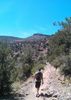
| partners | | | Great Saturday adventure with the Droog. We put in on the Agua Fria at the far north end of Lake Pleasant where Table Mesa road stops. We spent the first mile alternating paddling and boat dragging, we were about 2 inches shy of enough flow to keep floating the whole way. After the first mile, we came upon the north boat ramp, which I did not know existed. It is open only from 8-4 and can be reached by 4x4 (or well skilled high clearance 2wd), you have to drive across the Agua Fria to get to it. We paddled all the way out and up the bay into Tule creek, and circled the lake portion up here that is not closed for the bald eagle nesting areas. On the paddle back we pulled into a bay on the east side of Indian Mesa for the second portion of our trip. We followed an off trail wash up to the Cow Creek road/trail to make our way around the north end of Indian Mesa. We made the steep climb up the Mesa and explored around and took a nice break to enjoy the sights. We retraced our steps back down to the boats, paddled back to the north ramp, left the boats and hiked back to the truck. Then we made the short mile drive back to load up and head home. My phone gps/route scout were not cooperating well today so mileage is an approximation, I figured about 9 miles of paddle and 3 miles of hiking. We saw a ton of wildlife, storks, cormorants, and ducks galore on the water. When we pulled in to start our IM hike, we dispersed a mixed herd of burros and tagged cattle, I have never seen them so happily comingling. All in all a fantastic day in the wild, without the powerboat yahoo's of the lower end of the lake. Win! |
|
Wildflowers Observation Light
Brittlebush with some Lupine and paintbrush |
|
| _____________________
| | |
|
|
|
 Route Editor


](https://hikearizona.com/dex2/images/smilies/eusa_wall.gif "Brick wall") of listening to them the entire time. Then, while in hiding, a few of them wondered off looking for an area to,um....well you know (poop)...... so I kinda walked the other way, but they were gracious enough to leave the toilet paper and mess for all the enjoy
of listening to them the entire time. Then, while in hiding, a few of them wondered off looking for an area to,um....well you know (poop)...... so I kinda walked the other way, but they were gracious enough to leave the toilet paper and mess for all the enjoy 
