username
X
password
register
for free!
help
ArticlesGuidesRoutes
 
Photosets
 
 Comments
triplogs   photosets   labels comments more
Boulder Mail Trail - 3 members in 5 triplogs have rated this an average 3.3 ( 1 to 5 best )
5 triplogs
login for filter options
Apr 26 2023
avatar

 Guides 94
 Routes 840
 Photos 22,055
 Triplogs 1,993

52 male
 Joined Sep 18 2002
 Tempe, AZ
Boulder Mail TrailSouthwest, UT
Southwest, UT
Hiking avatar Apr 26 2023
chumleyTriplogs 1,993
Hiking20.27 Miles 3,000 AEG
Hiking20.27 Miles2 Days         
3,000 ft AEG
 no routes
1st trip
Linked   none no linked trail guides
Partners partners
John9L
Utah in spring is a lot like Arizona in spring: unpredictable. We were prepared with lots of options and with a huge snowpack this winter and an unusually cool week for the end of April, we made some decisions on the fly and ended up choosing this as an overnight.

Day 1: BMT to Mamie Creek
11.40 mi, 1650aeg, 5:05
We set out from the upper trailhead and snaked our way across the various named benches, which seemed to have no defined start or end, while thoroughly enjoying the massive views this landscape provided.

Sand Creek was flowing nicely as we crossed and we found the thoroughly extinguished remains of a sheltered campfire from the very windy night before, which we later found to have been enjoyed by a group from Flagstaff.

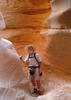
The mile and a half from Slickrock Saddle Bench and down into Death Hollow is one of the most amazing stretches of "trail" that I've ever walked. The photos simply can't capture this amazing canyon cutting through this indescribable geology. It is quite simply an amazing place. :)

Once in the hollow, we proceeded downstream, splashing in the water, stopping for an extended lunch break, and chatting with a couple groups we encountered. The water was chilly, but tolerable, and the poison ivy had not leafed out yet, so you could sort of pretend it wasn't there. 8-[

After two miles in the creek, the BMT climbs out of the canyon on a steep ridge that gains 800 feet in a mile. This hurt a little bit at this point in our day, but as we gained elevation, the views into the canyon once again proved spectacular.

Two more miles dropped us into the Mamie Creek drainage, where a pair of more experienced ladies had just sat down at the prime campsite near the crossing. The water here was intermittent, with no real flow, and a little bit red with tannins. After a surprisingly unsuccessful search for another spot to camp we found something we made work just downstream of the first big pool below the crossing.

Day 1 Extra: Mamie Natural Bridge
1.90 mi, 150aeg, 1:05
After setting up camp and enjoying a happy hour beverage, we set off on a dayhike downstream to Mamie Natural Bridge. The creek was mostly dry with some scenic pools and travel was quick and easy. The bridge is a worthy destination even if you're not camping at Mamie. Back at camp we settled in for the night with typical fire, lights, food and libations.

Day 2: Mamie Creek to Escalante Town Trailhead
6.8 mi, 1200aeg, 2:50
In the morning we made no attempt to get started early and finally hit the trail around 8:30. It's mostly uphill for the first 3 miles and this stretch was some of the least exciting of the whole trip. There was ample sand which got a bit tiring on our feet after a while, especially the slog across Antone Flat, though there were some pools of water there. As we climbed higher we got into more slickrock and the views opened up again, with stunning views of the snowcapped Henrys 50 miles east, and to Navajo Mtn about 65 miles to the south.

At the four mile mark the descent toward Escalante began in earnest, and much like the route into Death Hollow, this was a marvel of route making and super enjoyable with huge views. There was one unexpected little climb and the drop down to Pine Creek was annoyingly bouldery. The day had warmed up a bit as we descended in elevation to the Escalante River valley bottom and the last mile and a half dragged on a little as we were hot and tired finishing up the trip.

Ryan and I dropped 9L off in town before setting off for the 30 minute drive to shuttle back to the trailhead.

This is a great route and the views are second-to-none almost the whole way. There's not a lot of shade (thus, the good views) so I think I'd avoid it too late in the spring or early in the fall since the heat and sun would make it rough. But we had it pretty good for our timing and I'm glad this is the choice we settled on.
_____________________
I'm not sure what my spirit animal is, but I'm confident it has rabies.
  1 archive
Oct 20 2020
avatar

 Routes 181
 Photos 901
 Triplogs 259

50 female
 Joined Mar 09 2010
 Chandler, AZ
Boulder Mail TrailSouthwest, UT
Southwest, UT
Hiking avatar Oct 20 2020
azlaurieTriplogs 259
Hiking9.88 Miles 1,478 AEG
Hiking9.88 Miles   5 Hrs   33 Mns   2.00 mph
1,478 ft AEG      37 Mns Break10 LBS Pack
 
no photosets
1st trip
Linked   none no linked trail guides
Partners partners
dswitzer3
Route Scout Route Recorded  on Route Scout | Pop | Map | Popup | MapDEX
_____________________
♥ Timing is Everything ♥
  1 archive
Jun 06 2009
avatar

 Routes 166
 Photos 1,412
 Triplogs 61

78 male
 Joined Oct 02 2009
 Tucson, AZ
BMT - DH Part Deux, UT 
BMT - DH Part Deux, UT
 
Hiking avatar Jun 06 2009
SAMBATriplogs 61
Hiking
Hiking
 
1st trip
Linked   linked  
Partners none no partners
Boulder Mail Trail - Death Hollow Part Deux - A 2009 return to look "death in the eye" once again. The difference betwixt this adventure and my first BMT - DH adventure back in 2003 was this was a true loop hike which began and ended in the town of Escalante. On this hike/backpack my hikin' peeps, Kathie, Rosie, and Ruthie, and I started at the western end of the BMT, duplicated the stretch of DH I did in 2003, and, unlike in 2003, we hiked UPSTREAM rather than down the Escalante River back to the town of Escalante. My thanks go out to my new hiking buddy from Italy, Tugnein (aka Fabio Tedesco) who I met on EveryTrail.com for the use of his GPX file of a BMT - DH trip he did recently which was virtually identical to the one I did in '09. Oh yeah, while I'm in the "thanking" mood, I need to give credit to Rosie and Ruthie, but definitely not Kathie, for some of the pictures I'm posting. My last statement is not a slam against Kathie, it's just a comment on her penchant for ultra-light backpacking. "Camera? You expect me to lug a camera? Hell it was a battle for me to even bring a toothbrush".
_____________________
 
May 18 2007
avatar

 Guides 5
 Photos 26,458
 Triplogs 807

female
 Joined Feb 15 2003
 outside, anywher
Boulder Mail TrailSouthwest, UT
Southwest, UT
Hiking avatar May 18 2007
RedRoxx44Triplogs 807
Hiking
Hiking2 Days         
 no routes
1st trip
Linked   none no linked trail guides
Partners none no partners
This was part of a long month of hikes, etc in Utah May 07. Clearing out some pics on my computer and found some from that trip. It was a very nice overnighter, could be done as a long dayhike, over slickrock and fantasy land of Death Hollow. If you've driven Hwy 12 in Utah from Escalante and Boulder and been on the "hogsback" the view of the mounds of white slickrock is amazing. This is the terrain I covered.
I was dropped off in light snow and cold, my vehicle at the other end of the trail. This trek follows the old route of the mail travelers and the old telephone land line between Escalante and Boulder. And a lonely, lovely country it is. Water can be sketchy except at Death Hollow but I found potholes with clean water no problem. Follow the cairns closely, as it is easy to get cliffed out in this sandstone heaven.
This is a nice hike I highly recommend when in this area of Utah, a different perspective than the canyons of the Escalante.
 Geology
 Geology [ checklist ]
[ checklist ]  Navajo Sandstone
_____________________
 
Jun 22 2003
avatar

 Routes 166
 Photos 1,412
 Triplogs 61

78 male
 Joined Oct 02 2009
 Tucson, AZ
Boulder Mail Trail - Death Hollow, UT 
Boulder Mail Trail - Death Hollow, UT
 
Hiking avatar Jun 22 2003
SAMBATriplogs 61
Hiking
Hiking
 no routes
1st trip
Linked   linked  
Partners none no partners
I wanted to find out how Death Hollow got its name. Me thinks the caption on pic [ photo ] sums up what I found.
_____________________
  1 archive
average hiking speed 2 mph

WARNING! Hiking and outdoor related sports can be dangerous. Be responsible and prepare for the trip. Study the area you are entering and plan accordingly. Dress for the current and unexpected weather changes. Take plenty of water. Never go alone. Make an itinerary with your plan(s), route(s), destination(s) and expected return time. Give your itinerary to trusted family and/or friends.

helpcommentissue

end of page marker