|
| | | |
| |
|
| Hiking | 10.22 Miles |
2,050 AEG |
| | Hiking | 10.22 Miles | 5 Hrs 46 Mns | | 2.14 mph |
| 2,050 ft AEG | 1 Hour Break | | | |
|
|
| |
| Partners |
|
[ show ]
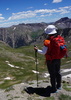
| partners | | very fun loop that has been on our radar for about a year now
@azwanderingbear and @azbeaver were able to join @tibber and i for it
we started from yavapai vista but there are other options for parking
best to go counterclockwise so that you meet the mountain bikers descending hiline head on
we added cathedral rock from templeton since wade and mary jo hadn't been up there
also took the long way on baldwin, but another time we would take the cutoff for better scenery
all the trails were nice, providing a variety of views and terrain
templeton dropped down to oak creek, where we stopped for a snack
very lush and green along the creek
saw a hawk swoop down and snatch what we think was a frog out of the creek 
the west side of baldwin was the least interesting, but hit the hiline soon enough
great trail with a couple of gnarly climbs and a good stretch on slickrock similar to hangover trail
dropped back down to slim shady and out
saw a few hikers on templeton, tons on the cathedral rock trail, a few near the creek and some bikers on hiline
can't imagine going down those drops
perfect temps all day, slightly overcast much of the time, and slight breeze
very enjoyable day with good company
nice to get out with mary jo and wade again
angela, we've picked some good ones this year
highly recommend this hike, keeping the cathedral rock spur but taking the shortest segment of baldwin |
| _____________________
| | |
|
|
|
 Route Editor


 ).
).


