|
| | | |
| |
|
| Hiking | 10.00 Miles |
|
| | Hiking | 10.00 Miles | 7 Hrs 30 Mns | | 1.33 mph |
| | | |
| |
| Linked |
|
none
[ show ]
| no linked trail guides |
| Partners |
|
none
[ show ]
| no partners | | I'll start the log by mentioning that I'm still not sure if it's "legal" to climb Red Mountain, since it's on the SRPMIC. Last year, their website just said that the Mountain is a preserve area. Now it's devoid of useful information. Since I've done some running on the reservation as well, I know about all the green signs that tell you "No Trespassing or Dumping" anytime you stray more than five feet from the main road and onto a side road. I decided that it's not legal to park on the res, and not worth it anyway. That leaves a couple of options for parking - 1) the first recreation area ($6 day use fee) as you go north on Power Rd and it turns into the Bush Highway, or 2) somewhere on the federally owned canal complex zone at the top of the hill right before the recreation area (free). It should be noted here that none of the canal banks or National Forest lands are on reservation property. A potential third option would be the Taco Bell on Shea Blvd, followed by a hike down the canal.
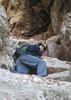
I tried this trip on Memorial Day weekend 2006. I parked in the $6 rec area. Since I didn't want to get wet, I went downstream a quarter mile from the dam, where there is a wide unpaved car/bike crossing available when it's not wet season. This area makes a good loop if you're a mountain biker. There's a dotted red line on this 12MB map made by Maricopa County that shows the dam as the end of a trail, but you could continue it along the Arizona Canal if you cross the river to the north bank. Once across the north bank, hikers will need to stay on the south side of the canal for a half mile until the bridge crossing, where a roadway follows north. This road is seldom used, and you can take a road heading east. If you go off the roadway, the terrain is passable, but it's also a giant cholla garden. Somewhere around here, you go over the underground canal. After going generally east and a little north for about a mile, and crossing some ravines, I came to the base of some buttes in front (to the south) of the main mountain. I went up into the saddle and came back down into a basin of sorts. In the basin across the drainage at the bottom, the trail up to the top can be found, although it takes a bit of imagination to stay on the trail for a while, since it's not marked and is very faint. The trail continues up and straight toward the summit, while staying to the right of a deep canyon. After going northeast for a bit, there's a draw going up from southeast to northwest. Going up the draw, the trail becomes more defined and after another 400 ft climb, you get to another saddle and can see the summit to the north. The trail is very defined at this point and goes NE before switching back NW. Near the top, you get a couple of ten-foot scrambles. Finally, you're just a few feet from the top on a mini-peak next to the actual peak which lies north. Unfortunately, there is a fifty foot canyon between the two mini-peaks. Fortunately, the canyon can be navigated by going down and back up. Unfortunately, when you get to the higher island, you see that it's a giant chimney-shaped rock forty feet high with sheer walls and there is no way to summit, at least no way that I saw. I didn't circle fully around the rock, so maybe there's another way. I was a little disappointed falling just a few feet short of the high summit, but it was right before sunset.
I found that the easiest way back to my car was the way I came, but not before finding a lot of ways that didn't work. At first, it looks like you can follow the drainage in the basin between the butte and the mountain all the way down to the southeast. But then it gets harder. And then there's a forty foot drop right before a fifty foot rise right before a 200-foot drop at the end. You can go around the 40 and 50 foot areas, but you'll turn around and go right over the west ridge when you see the big drop, just like I did. I also had plans to cross the river to get back to my car, but it was cool water and the air temperature wasn't much higher since the nighttime river area temps are 15 degrees cooler than the city. So after the water got to my waist and kept getting higher before I was even halfway across, I gave up and went the 4-5 miles around instead of making the straight shot across the river. At least I scared a couple of javelinas into the river. It was comical seeing the huge clumsy splash they made.
All in all, it was enjoyable for a while, before the long boring walk home back around the dam. I left the light at home, in order to travel unseen, but that led to picking up a few more chollas than I wanted to. The needles look so straight but they're so barbed.
I don't think it's illegal being on the reservation, since they don't have any problem letting you into Casino Arizona, and I've been running through the middle a few times as well. I didn't even cross any fences to get to the summit. However, if you're a law enforcement officer, I made the whole story up  , so don't come looking for me! , so don't come looking for me! |
| _____________________
| | |
|
|
|
 Route Editor