|
| | | Pyramid Trail 684 Sedona, AZ | | | |
|
|
Pyramid Trail 684 Sedona, AZ
| | |
| |
|
| Hiking | 2.75 Miles |
381 AEG |
| | Hiking | 2.75 Miles | 1 Hour 54 Mns | | 1.50 mph |
| 381 ft AEG | 4 Mns Break | | | |
|
|
| |
| Partners |
|
none
[ show ]
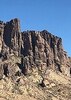
| no partners | | Our goal - a loop around Pyramid Mountain. We accessed the loop via a short spur from the Pyramid Mountain trailhead at Red Rock Loop Road and Chavez Ranch Road. The loop itself, going clockwise, consists of Pyramid Trail, then when one reaches the northwest, a right onto Scorpion, then back to the spur to the trailhead.
My wife and I took the trail starting a few minutes after Coconino National Forest reopened at 6 am on July 6. Pleasant hike. The loop offers texture and variation underfoot, weaving through an open juniper-pinyon forest, and featuring energizing but modest up and downs. We took the hike as a two hour effort, to enjoy the red rocks and scenery, while doing do so enjoyably before the July heat arrived. The loop offers partial shade in places, and vistas (though looking into the sun) to the southwest towards Cathedral Rock and then to the northeast at Capital Butte. But the main geological features consist of those on Pyramid Mountain, i.e. nice red rock layers with cliffs, formations and the every present rounded slick rock platforms. In terms of biking, the loop (appears to) offer (not a mountain biker myself) good by less then perilous challenges, with the loop's collection of twists, minor ledges, rocky terrain and quick burst climbs. We saw three bikers, just as pleased as us at the reopening of the forest.
The loop offers (at least) two unregistered side trails. One starts at the south part of the loop, running outward from the center of the loop, up a modest rise to a peak I believe to be named Cimarron Butte. I hiked up solo on a previous trip - nice vistas available. This trip, respecting a joint desire to keep an easy pace while beating the heat, we climbed up only part way. The second side trail leaves the loop on the back side, on the west, and runs directly up and over and down Pyramid Mountain. Nice bit of adventure, as I also took this solo on a previous hike, but here on this trip adventure wasn’t the goal. The trail over the top stands out fairly distinctly, with good continuity and a fairly direct path, but its does weave around obstruction and boulders a good bit, so one needs to be vigilant to follow. Note though the portion over the very top does present difficulty, as the top has flat rock with little indication of where the trail goes (all the way the length of the top).
But back to our loop this day. As we proceeded clockwise, on the north side coming around on Scorpion, the trail runs up a bit on a slanted ridge, and one can see in the distance the trail running across the base of Pyramid Mountain. I generally like that type of view, of the trail in the distance.
We arrived back at the trailhead in two hours, plus or minus. Of interest, when we entered just after 6 am, the closure signs, and the yellow caution tape stretch across the trail entrance, both still were present. When we left, Forest Service workers, and/or we surmise volunteers summoned up to help, had removed all the closure signs, tape and cones. Nice, quick work. |
| _____________________
| | |
|
|
|
 Route Editor