|
| | | |
| |
|
| Hiking | 4.50 Miles |
1,064 AEG |
| | Hiking | 4.50 Miles | | | |
| 1,064 ft AEG | | | | |
|
|
| |
| Linked |
|
none
[ show ]
| no linked trail guides |
| Partners |
|
none
[ show ]
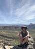
| no partners | | After throwing a bunch of camping gear in my truck at home, I set off down the highway, knowing I might not have enough time to hike Greenback Peak like I had been hoping. Greenback had been on my wish list for several years, and I was really looking forward to hiking it. I put my truck to the test driving up Forest Road 236, and began my hike at 3:50 pm. I moved fast, and was on the south end of Greenback Peak in just under an hour.
While trying to free myself from a thick patch of manzanita near the south cliff edge, I noticed a few stacked rocks peeking out of the tangled mess. A ruin? A quick scan around my feet revealed a few pottery sherds, and collapsed wall lines. Indeed. Cool, a little ruin. A short time later I found more connecting walls. Correction: a good sized ruin.
Pushing on through the manzanita, I stumbled, fell, and fought my way farther to the summit. Upon reaching the top, I broke free from the brush, and discovered another wall. A quick survey revealed a very large ruin, with multiple rooms, and a massive outer wall. Wow! I glad I came up here! 
With the sun setting, my time on the summit was limited, so I went to work photographing the area. I climbed atop the summit boulder, and placed a summit register among the rocks. Fittingly, the notebook was green, and so was the jar lid.
With the evening breeze growing chilly, I pulled out my fleece, and out popped my video camera, bouncing off the boulder, and sliding toward a deep crevice. I caught it, and thankfully, it still worked. I shot some video, then began my return bushwhack at dusk.
I finished my hike by moonlight, dropped the tailgate on my truck, and contemplated where to camp out for the night. As cold and breezy as it was, I chose to head back toward Tonto Basin. Now came the fun part: driving back down FR 236's nasty switchbacks in the dark. A short ways down the steep, bumpy road, my brakes locked up or something, and I nearly lost control.  What that was all about, I didn't know, but I dropped the truck into 4wd low and 1st gear, and crawled down the nasty stretch at 4 mph, without having to touch the brakes. I didn't have any more problems after that. What that was all about, I didn't know, but I dropped the truck into 4wd low and 1st gear, and crawled down the nasty stretch at 4 mph, without having to touch the brakes. I didn't have any more problems after that.
Eventually I settled on a nice side road a few miles above Tonto Basin, where I set up my tent in the bed of my truck (not wanting to take a chance with my Thermarest and cactus spines). I cooked up a package of delicious creamy chicken Ramen, and sat in the wind free confines of my truck, where I watched an episode of the Dukes Of Hazzard on dvd. The next morning I was up at dawn, and it was off to meet John at the Butcher Hook for our backroad adventure on the Malicious Gap Road (Forest Road 609).
Greenback Peak was a fun and very memorable trip, and one that I highly recommend! |
| _____________________
| "…you never know when a hike might break out" -Jim Gaffigan |
| | |
|
|
|
 Route Editor


](https://hikearizona.com/dex2/images/smilies/eusa_wall.gif "Brick wall")


