|
| | | |
| |
|
| Hiking | 9.42 Miles |
1,548 AEG |
| | Hiking | 9.42 Miles | 6 Hrs 29 Mns | | 2.07 mph |
| 1,548 ft AEG | 1 Hour 56 Mns Break | | | |
|
|
| |
| Linked |
|
none
[ show ]
| no linked trail guides |
| Partners |
|
[ show ]
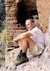
| partners | | For the second year a row, one of my hiking partners won permits to The Wave and invited me to join, so I was fortunate enough to visit a second time in ~16 months. With permits on Saturday, we planned a five-day/four-night trip around Kanab to see a few different areas around northern Arizona/southern Utah. The weather was perfect when I visited in May last year...unfortunately, the forecast this time had high probability of rain starting around noon. And when permits are involved, postponing until the weather improves isn't an option. All we could do we get an early start, hope the forecast was wrong, but prepare for rain and see as much as we could see...
We left Kanab very early and were on the trail before sunrise, starting the hike by flashlight/headlamp. Light rain started before 7AM, and we had to pull out the raincoats less than half a mile into the hike. Fortunately, that first round was light and short-lived, and we ended up having a nice sunrise as the clouds started to break up a little. We skipped Mini Wave and headed straight for The Wave, hoping to have it to ourselves for at least a few minutes since we'd seen another group behind us on the trail. It was an advantage having been here before, and we followed a better route that avoided some of the slower sandy areas and stayed on the rocks most of the way.
We were lucky enough to have The Wave to ourselves for 15-20 minutes before anyone else showed up, so we explored and took a bunch of pictures. Mid-day is typically the best time to visit The Wave for the sun angle, but the slightly overcast sky worked to our advantage and blocked what would have been harsh morning shadows at that time of day. As people started to show up, we moved on toward Second Wave, and there were a few small pools above The Wave that provided some nice reflections. We had Second Wave to ourselves for a while, too, and ate a quick snack there before more people started showing up.
Last year, I didn't get to see Melody Arch or The Alcove--my friend and I tried to take a direct approach going south from The Wave up the cliffs, but the route was very steep and we ran out of time. For this visit, I mapped out a route around the east side of the cliffs, so we headed around that way and a found an easy route up on top of the cliffs. Our first view of the window at Melody Arch/The Grotto was an optimal illusion that looked like a dark stain on the rock wall, but once we got closer, we could see blue sky up through the window.
There were two other groups at Melody Arch when I got up there, but they soon took off, and we had that area to ourselves, too. That ended up being one of the highlights of the day--between the arch and the window, The Grotto is an impressive spot, we could see Hamburger Rock/Big Mac to the south through the window. From there, I went north and saw The Alcove from above, and we made our way down and around inside. There was a lot more to it than what I'd been able to see from the ledge above--there was an undercut area with beautiful, streaked sandstone formations and a small pool of water with tadpoles.
Melody Arch: [ youtube video ]
The Alcove: [ youtube video ]
We'd been keeping an eye on the clouds all day, and the southwest sky started to get dark quickly as we left The Alcove, so we knew we needed to get going. As we made our way back toward The Wave, it continued to get darker, and we could see the mass exodus of people streaming north to get out of there as the storm approached. It started sprinkling near The Wave, so we pulled the rain jackets out again, and we talked briefly with the volunteer checking permits before we took off in hurry.
Thunder started soon after that, then strong winds and sheets of heavy rain hit. We paused to put our important stuff in a dry bag and pushed ahead, keeping up with the large stream of people ahead of us. It was incredible how quickly the weather turned and how much water accumulated in just a few minutes--there were heavy streams of water flowing down the cliffs and large pools forming on the rocks, and I started to wonder if the washes ahead of us would flood and block our exit. Off to the east, there were waterfalls cascading down the cliffs, but the strong winds were blowing the water back up and over the tops of the mountain, making it looks like the water was flowing in reverse--it was an incredible scene.
[ youtube video ]
That first storm let up and the rain stopped, and the first main wash we needed to cross had some water accumulating but was passable. We heard one of the guides for the other groups up ahead say that there was another round of storms coming. With about a half mile to go, the rain started again, and we heard the guide yell for everyone to get out of the wash we were following.
As we crossed Coyote Wash for the final time across the road from the trailhead parking lot, it was starting to flood and had a few inches of water, but it was still shallow enough to cross safely...it was a good thing we hadn't waited any longer to start back from The Alcove  . We debated whether to try driving out or wait for the storm to pass--a sign on House Rock Road just off Highway 89 warned, "Road Impassable When Wet." A small SUV started driving back toward the highway, so we switched on 4x4 and followed them...we'd be able to see if they had any trouble on the road, and if they could make it with lower clearance, we'd be fine. There was one muddy stretch where we did some sliding, but the water was low in the washes, and we made it back to the highway. . We debated whether to try driving out or wait for the storm to pass--a sign on House Rock Road just off Highway 89 warned, "Road Impassable When Wet." A small SUV started driving back toward the highway, so we switched on 4x4 and followed them...we'd be able to see if they had any trouble on the road, and if they could make it with lower clearance, we'd be fine. There was one muddy stretch where we did some sliding, but the water was low in the washes, and we made it back to the highway.
The storm cut our day short, so we didn't have time to see The Boneyard or the dinosaur tracks, which was disappointing. But I'd seen those last year, and the storm, the flooding, and the "reverse waterfalls" were an incredible experience that was probably more unique than seeing those places for a second time. The effect of the increase in daily permits was obvious with the number of people I saw this time compared to last year...not sure how I feel about that, though the permit increase may have been the reason I was able to come back a second time. Regardless, it was another memorable experience at The Wave, though very different from last year. |
  |
Coyote Wash |
Medium flow |
Medium flow |
| | | Dry on the way in, starting to flood on the way out | | | |
|
|
|
 Route Editor


 . It soon got a little chilly so it was on to the SECOND Wave that Sirena, Wendy, Sarah and me didn't find in 2011... and for a very obvious reason. We went down and around when we should have stayed above THE Wave and headed west.


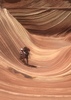


 I don't have to do any explaining. It's one of the must do's for any hiker. It's absolutely beautiful. Going in, I thought it would be just one big bowl. It's actually a few smaller "channels" that you hike through. It's also very easy to climb up above and around it. I spent well over an hour just wandering around taking pictures.


