|
| | | |
| |
|
| Hiking | 0.50 Miles |
200 AEG |
| | Hiking | 0.50 Miles | 35 Mns | | 0.86 mph |
| 200 ft AEG | | | | |
|
|
| |
| Linked |
|
none
[ show ]
| no linked trail guides |
| Partners |
|
none
[ show ]
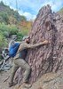
| no partners | | Made it down under the Natural Bridge for the first time in several weeks today.
Despite the consistent rumors I keep being told, all park trails are open. If you plan to visit, check the park website (NOT GOOGLE FOR THE LOVE...) for condition updates or call the office.
My route today was the Gowan-Pine Creek (under the bridge)-Anna Mae Loop, which is just a hair over a half mile and took me about 35-40 minutes to complete, including the time it took to stop and chat with some visitors. Watch for loose rocks on the Gowan and Anna Mae Trails. As always, the rocks under the bridge are slippery as snot, EVEN when dry. Follow the yellow and brown arrows for navigation.
If you're a birder, watch and listen for Canyon Wrens on the walls and cliffs of the Bridge and Canyon, they've been quite active recently. Other feathered friends seen throughout the park include the two resident Ravens: Bonnie and Clyde, Bluebirds, Cardinals, and Flickers with two brain cells fighting for third place.
Coues' White-tail deer and Javelina make appearances almost daily. White-nosed Coati are also seen about 2-3 times a week, always a crowd favorite.
Pine Creek continues to trickle under the sole power of the springs within the park. Upstream of where the springs drop in at the end of the Waterfall Trail, the creek is dry, dry, dry. We need rain badly. I can't believe that only eight months ago, I was standing on the metal deck watching logs the size of telephone poles porpoise through the bridge in a maelstrom of foam and spray. The water level of the insane flooding is still easily observable based on the debris it left behind. Side note: it's a bummer there isn't a water report marker here for Pine Creek. I'd be updating that all the time if there was one. |
|
Autumn Foliage Observation Isolated
Some Willows are still barely hanging on, but they're going to be gone by the end of the week, especially if we get the predicted rain Wed-Friday. |
|
|
Wildflowers Observation None
None right now, although I anticipate we'll be getting some random perennials with the next burst of rain if the frost doesn't nail them. I've seen things like Mock-vervain bloom as late as this time of year in the right conditions. |
|
| | |
|
|
|
 Route Editor