|
| | | |
| |
|
| Canyoneering | 10.50 Miles |
1,100 AEG |
| | Canyoneering | 10.50 Miles | | | |
| 1,100 ft AEG | | 50 LBS Pack | | |
|
|
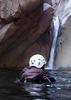
| | Basic Canyoneering - Scrambling; easy climbing/downclimbing; frequent hand use; rope recommended; easy exit | | B - Up to light current; wading/swimming; possible wet/dry suit | | III - Normally requires most of a day |
| |
| Linked |
|
none
[ show ]
| no linked trail guides |
| Partners |
|
none
[ show ]
| no partners | | This canyon had some exciting moments, it was beautiful in the fall, you never see colors like that in the valley. I think we spent the majority of our trip rock hopping with wet slippery shoes, so I wish the narrows had lasted a bit longer. The area was burned in 2012 and you can still see and feel the effects. There was quite a bit of charred debri in the canyon, log jams were fragile and looked crispy, charred rocks were cracking, one of the pools we swam through was full of wood chips. It was like swimming through a flooded playground. I think the guide book said we would be swimming through 3 pools, I counted 5 actual can't touch the bottom pools, there are other ones that went up to our torso, or could be avoided all together. We replaced the anchor with a wrap 2 pull 1, and used about 10 ft of webbing around a choke stone NBD.
*** edit: I should also add that because of all the added obstructions due to the semi-recent fire, this trip took us about 9 hours, the book said 5-8 ***
Things we used:
- GPS (plot your way points before you leave)
- helmet
- grommetted backpack
- large dry bag
- wet suits
- harness
- repelling device of choice
- PA (but this rappel wasn't awkward to get on so you didn't really need one.)
- enough water for a day hike.
- snacks for a day
- change of undergarments, or swim suit
- knife
- lighter
- a good driver, who doesn't mind taking their car on maintained dirt roads, with small obstacles.
*bug spray would be helpful but we forgot it (there were swarms of small mosquitoes)
*We brought a headlamp too just in case, but found we didn't need it
*also a water proof first aid kit was nice to have
Pro tip: You don't have to hike along the 231 the whole time. If you have your GPS, you can save yourself some time and walk from the road across a field to where your car is parked, instead of walking all the way around save you about 30 minutes, or just stick out your thumb and hitch a ride- seems like a popular road for hunters in the fall. |
|
Autumn Foliage Observation Substantial
The trees were just changing colors, it was so beautiful to watch the leaves fall like confetti. They made things a bit more slippery to walk on, but the scenery was more than I could have hoped for. Most guide books recommend doing this canyon in the summer because there is a lot of water to swim through. I would say bring a 3mm wet suit and do this in the fall. |
|
| _____________________
| | |
|
|
|
 Route Editor