|
| | | |
| |
|
| Hiking | 3.75 Miles |
1,033 AEG |
| | Hiking | 3.75 Miles | 2 Hrs 40 Mns | | 1.41 mph |
| 1,033 ft AEG | | | | |
|
|
| |
| Linked |
|
none
[ show ]
| no linked trail guides |
| Partners |
|
none
[ show ]
| no partners | | After hiking Picketpost Mtn near Superior, Brian and I had enough time and energy to do another hike. We drove to Superior, AZ and then South on AZ-171 to get to a road heading to Steamboat Mtn. Along the way, we saw Teapot mountain, which was a difficult but enjoyable hike that I did in January, and also passed the huge Ray mine. See my driving directions below to see how to get out to this mountain.
From my starting point which was 3.0 miles from AZ-171, we started hiking North on the old 4x4 road. I'm glad we didn't drive any further because this road started looking more like a rocky wash. If you can make it 3.0 miles with a 4x4 vehicle, you've done very well. In fact, I would recommend parking after 2.5 miles. Continuing hiking down the road. There were sections that seemed to lead into a wash which we later learned was called Steamboat Wash. Stay on the right side of this wash and look carefully for the old road. This road probably hasn't been used in 50+ years. It was washed out and overgrown in many parts and in some places there were big trees in the road. In some places you may find it easier to walk in the wash which was wide and mostly open. But, keep in mind that there was a road to the right of the canyon and it's difficult to find in many areas.
After hiking about 0.6 miles we saw a junction. A road headed left and out of the main canyon. We took this road and within a few minutes realized this road was not going the way we wanted, so we went back down to the canyon and took that canyon continuing North. We stayed in the canyon for a while, until we hiked a total of 1.2 miles. After looking at the topo map, we realized we went a bit too far North and needed to hike South and East to get back to what was labelled on the topo map as an old road. We climbed out of the canyon and found flat areas which could have been road at one time. After getting 1/3 of the way up to the saddle, we saw some flat areas which was followed that appeared to go up toward the saddle. When these flat areas got hard to follow we just went up. It was a pretty light bushwhack the way we went because there were a few open areas.
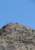
Eventually we made it to the top of the ridgeline just South of the saddle and we were looking at a rocky area. I found only one published route on HikeArizona.com but it did not go all the way to the top. I edited this route, drawing in a path to the summit just based on what the topo map looked like. But, with no other information, we didn't know if this hike would be possible without ropes.
When standing up there, based on the look of this rocky area, we knew we would have to do some climbing here and were hoping there was nothing above Class 2 or 3. Luckily, we found a channel going up between some rocks and decided to take that. We kept channeling up through the rock and just took the path of least resistance. Pretty soon, the graded got easier and we noticed a cairn up ahead. We climbed up to it and from there we felt like we were going to summit this one. The climbing was mostly class 2 with a few class 3 areas with minimal exposure. Once on top, we needed to walk West a few hundred feet to get over to the high point. We had to walk directly into the sun to get to the summit, as it was late in the day.
At the summit we found an old jar that was exposed to the sun for probably many years. We both tried to get the lid off but could not. The lid was rusted on. Luckily, I had a new glass jar with me. We had to break the old jar to get the contents out which were in really bad shape. The sun damage had nearly burned the paper but we were able to read and take photos of some of the entries. We placed a new jar there and put the old shredded paper inside although much of it was unreadable. We decided to shade the jar better from the hot sun, so we made a small enclosure with the rocks and covered the jar. Hopefully this one will last longer and people will continue to cover it from the sun. The last registry entry we saw was from 2013, over 10 yrs old.
We figured we had about 20-30 minutes before sunset so we took our photos and got out of there. We remembered passing by a palo verde tree where we saw the last cairn. On the way down, we actually saw about 10 cairns, following each one and we ended up hiking in the same place we came up, for the most part. I don't know why we didn't see these cairns on the way up. I guess we weren't looking for them and were so focused on just making it to the top. We follow the cairns down, went to the saddle below and made a left. We knew the road didn't go to the saddle, so we just looked for clearings and flat areas while heading back the same way we came, looking for any signs of a road. We felt like we were on an old road at one point and then it disappeared, then we'd see other areas below that looked like old roads. We kept doing this until we could see the canyon. Along the way down, we saw some mine tailings and some mostly filled-in holes where it looked like there was mining activity years ago.
Further down, the road seemed to end right on the edge of the canyon. There was about a 10 or 15 foot drop-off and we couldn't see how the road could have gotten down there. Then, we looked North and noticed a cairn which marked a way to get down into the canyon, so we took that route. Maybe the road at one time went that way. Once in the canyon we walked South and stayed on the far left for a while, looking for pieces of roads along the way. At one point you will need to take a road on the left side to get around a cliff in the wash. But, you can also follow the wash, for the most part. Our route has a few variations between up and down but I would say our route going down was slightly better. By the time it got dark, we were only about 1 mile away from the parking area. We put our headlamps on to see better in the wash and on the rocky road. As we got closer to the parking area, the road got slightly better from a walking perspective, but I would not want to drive any further than I did and I would even recommend parking after 2.5 miles of driving.
It felt nice to make this summit not knowing if our route would work. I believe my published route is the only route to this summit published anywhere on the internet as of this writing!
Driving directions: Take AZ-171 South toward Kearny. In the small town of Kearny you will want to make a left on Hammond Dr. going East. There's a church here on this corner and two white colored tanks that you may be able to see from the road. The road starts off paved but turns to gravel pretty quickly. For the first 1/2 mile stay right to keep away from the private property. At some point you should see a sign labeled "trail 1" for this road. We thought trail was really a more appropriate name than "road". You'll need to have a 4x4 high clearance vehicle to get to the place where we started hiking, but you may be able to get by with a high clearance vehicle for the first 2 to 2.5 miles. The road is pretty decent for the first 2.5 miles and then gets progressively pooey after that. There were a few wash crossings along the way. After about 2.5 miles, there were several times we needed to get out and move so large rocks out of the road. After doing that a few times, we just decided to park and walk from there because it was probably faster to walk at this point. We ended up driving 3.0 miles and parked in a rocky area just off the road. If I had to do this drive again, I'd probably go only 2.5 miles and park. We didn't expect to see anyone else out there and we did not. See my GPS route for more details.
My Stats:
--------------
Distance (round trip) = 3.75 miles
AEG = 1,033 feet
Strava moving time = 1 hr 58 mins
Strava elapsed time = 2 hrs 58 mins |
|
Wildflowers Observation Isolated
white mariposa lilies, poppies, brittlebush, scorpion weed |
|
| _____________________
Michael Williams
IT Professional
Rocky Point Vacation Rentals
Ocean Front Condo in Rocky Point, Sonora, Mexico
www.beachfrontmexico.us
 |
| | |
|
|
|
 Route Editor