|
| | | |
| |
|
| Hiking | 2.50 Miles |
240 AEG |
| | Hiking | 2.50 Miles | | | |
| 240 ft AEG | | | | |
|
|
| |
| Linked |
|
none
[ show ]
| no linked trail guides |
| Partners |
|
none
[ show ]
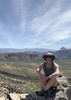
| no partners | | For a hike that featured trash and litter for most of its duration, this will prove to be one of my more memorable ones, because of the ruins. The litter only stopped as I made my way up the hill. It took me some stumbling around, but once I turned a corner and the ruins appeared before me, I was speechless. At least two "rooms" are clearly definable, including the apparent ceremonial chamber that is the largest one. There is a fire pit in the ceremonial chamber. There are at least two entries to the ceremonial room that can easily be spotted.
Not having explored or even found any ruins on my own during my lifetime of hiking in Arizona, I was completely mesmerized and it was hard to tear myself away and go home. The imagination runs wild while standing there in the room, with its expansive views. I assume that the location was strategic, because of the expansive views and proximity to water. The effort to build just the portions of the structure that are still intact was a significant group task, given the hundreds of rocks used and their heavy weight.
I did spot a pair of bluish-grayish herons or cranes on Tonto Creek.
The general advice of hiking along the east bank of the creek is still good. Most of the hike to the base of the hill is on a 4x4 path. I walked for about 10 minutes through unmarked brush to the point where Cocomonga Canyon intersected. If there's a clear path up the hill, I didn't find it. |
| _____________________
| "Facts are stubborn things; and whatever may be our wishes, our inclinations, or the dictates of our passions, they cannot alter the state of facts and evidence." --John Adams |
| | |
|
|
|
 Route Editor