username
X
password
register
for free!
help
ArticlesGuidesRoutes
 
Photosets
 
 Comments
triplogs   photosets   labels comments more
4 triplogs
login for filter options
Oct 02 2004
avatar

 Photos 78
 Triplogs 4

69 male
 Joined Aug 19 2004
 Mesa, AZ
Cave Trail #233Phoenix, AZ
Phoenix, AZ
Hiking avatar Oct 02 2004
pbutler1Triplogs 4
Hiking6.36 Miles 1,400 AEG
Hiking6.36 Miles   5 Hrs   21 Mns   1.19 mph
1,400 ft AEG
 no routes
1st trip
Linked   none no linked trail guides
Partners none no partners
Arrived at Peralta trail head about 6am Saturday morning and 3 other groups were already in the parking lot. Headed out on Bluff Springs trail, ascended Cardiac hill and continued North to the junction with Cave trail. Scratched my head a bit about where the junction actually was... but I could see the trail climbing the next hill and went through the brush until I reached it.

After climbing this hill the sun was coming up and caught some of the Hoodoosin the morning light looking towards the east and also towards the westalong Peralta trail. A bit later the Devil's Slide came into view. I took the backside route around the peak containing Geronimo Cave and captured the Moonrising above its peak. Still on the backside I found some interesting purpleflowers, some shadowed formationslooking down towards Upper Barks Canyon, and some good morning views of Weavers Needle. Finding my way from the backside back to the Cave trail proper was a bit of a challenge that yielded both the trail and another type of purple Flower.

Arriving at the overlook Northeast of Fremont Saddle I found the famous pine tree, a lone Saguaro, and some Agaves framing the Needle. One last shot of the Needleand some Agaveswatching the moonrise and then I started back down Cave Trail towards the parking lot.

Returned to a very full parking lot 11:21am. None of the owners were on Cave Trail, most were on Peralta and I had seen a few groups on Bluff Springs.

With some intentional and more than a few route finding diversions total travel distance was 6.36mi
 Meteorology
 Meteorology [ checklist ]
[ checklist ]  Moon
_____________________
 
Sep 24 2004
avatar

 Photos 78
 Triplogs 4

69 male
 Joined Aug 19 2004
 Mesa, AZ
Weaver's Needle Loop from Peralta THPhoenix, AZ
Phoenix, AZ
Hiking avatar Sep 24 2004
pbutler1Triplogs 4
Hiking12.20 Miles 3,122 AEG
Hiking12.20 Miles   7 Hrs   15 Mns   1.68 mph
3,122 ft AEG
 no routesno photosets
1st trip
Linked   none no linked trail guides
Partners none no partners
Headed north towards the saddle from Peralta trailhead at 6:12am. About halfway up the sun penetrated the canyon and highlighted a cluster of Saguarosnestled in the rocks on the westside of the canyon. Looking eastward a few of the higher rock formations caught some of the early morning light creating interesting shadows. The rock formationsalong the west side of the trail approaching the saddle are some of my favorite photo subjects. In the morning light the shadows sharpen the featuresand the intense yet more yellow sunlight gives the rock a golden brown hue. At this time of day the sky is a deeper blue toward the west and the heat had not built up enough to burn off the clouds which formed during the night. These formations are interesting because many have forms that suggest life. Reached the saddle in just over an hour and took this shot of Weavers Needletowards the north.

Descending from the saddle heading north towards the needle the lighting, sky, clouds, and especially the formscreated many more interesting photo ops. I again reached the point where the canyon walls on the east side created a shadow lineon the west wall. As I neared the needle still on Peralta Canyon Trail I came across an unlucky animaldecomposed enough that I could not identify it. As I neared the entry to Boulder Canyon I captured some interestingviews of the needleagainst a shadowed foreground.

I continued on Peralta Canyon to its intersection with Dutchman trail (named Needle Cutoff trail on the topo map) in Boulder Canyon. Heading east I followed Dutchman upwards and towards Needle Canyon for about 1 mile reaching the intersection with Terrapin trail which runs alongside Needle Canyon heading south. I took Terrapin to Terrapin pass and on to Bluff Saddle and then down to the intersection with Bluff Springs trail (Dutchman's according to the topo map). I descended into lower Bark's Canyon and ascended to the point where the trail intersects the Cave Trail and then down cardiac hill to the trailhead.
_____________________
 
Sep 12 2004
avatar

 Photos 78
 Triplogs 4

69 male
 Joined Aug 19 2004
 Mesa, AZ
Peralta to Fremont SaddlePhoenix, AZ
Phoenix, AZ
Hiking avatar Sep 12 2004
pbutler1Triplogs 4
Hiking4.50 Miles 1,366 AEG
Hiking4.50 Miles   3 Hrs      1.50 mph
1,366 ft AEG
 no routes
1st trip
Linked   none no linked trail guides
Partners none no partners
Started out about 5:15 pm to get some sunset photos of the saddle area. Saw two people coming down but otherwise I had the trail to myself - which is unusual. About half way up the hill I took this shot looking back down the trail towards the south and another looking upwards to the north east. Sunset started before I reached the saddle and I took some interesting shots of the skyagainst the backdrop of the spires on the west side of the trail nearing the saddle. And another dramatic shotlooking towards the east side of the trail. One final shot of the skyagainst the spires then I started down. Along the way I met several Tarantulas and got a good picture of one of them. As it got dark I needed a flashlight to navigate the washes on the lower half of the trail. I returned to a deserted parking lot around 8pm.
_____________________
 
Sep 03 2004
avatar

 Photos 78
 Triplogs 4

69 male
 Joined Aug 19 2004
 Mesa, AZ
Flatiron Hike - SuperstitionsPhoenix, AZ
Phoenix, AZ
Hiking avatar Sep 03 2004
pbutler1Triplogs 4
Hiking4.80 Miles 2,780 AEG
Hiking4.80 Miles   6 Hrs      0.80 mph
2,780 ft AEG
 no routes
1st trip
Linked   none no linked trail guides
Partners none no partners
Made my 1st attempt on 8/29/04 both unprepared (No Water!) and out of shape. Made it to the parks turn around point and went right before reaching the mini fall and then up. Entered a densely brushed canyon and fought my way up 700' or so. Became exhausted and dehydrated. Took some pictures and started down. Had a pretty good case of heat stroke by the time I got back to the car. Why am I telling you this? Because you should be smarter than this and always bring water!! And the first time you do a hike follow the trail!!

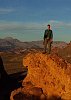
Made my 2nd attempt 9/03/04. There were some great clouds forming and quite a bit of moisture in the air - perfect for some dramatic pictures. This time I had 3 liters of water, some food, and even a snake bite kit. Started up about 2pm. Still not in the best of shape, so I took my time in order to make it to the top. Saw about three people ahead of me on the trail and passed 2 people coming down. Climbed up the mini water fall and shortly after followed the trail out of the canyon to the right - this is a bypass for the 10' waterfall you have to climb further up the canyon. As I reached the top of this segment of the trail, there was the option to descend back into the canyon and to the trail or climb up to the ridge that leads up to the base of Flatiron. I took the scramble up towards the ridge. As I crested the ridge, I descended slightly down the south side and traversed towards the base of Flatiron. This provided some more dramatic photo ops for Flatiron and a really good view of the valley towards the San Tan mtns. Continued to the base of Flatiron and saw a fairly large dust storm building toward the south by the San Tans. Traversed the base of Flatiron back towards the canyon and the trail. Ascended the trail and turned left to go to the very top of the mountain. Finished the ascent in about 3 hrs including the detour.

Others have commented on the great 360 degree view - it is fantastic especially with very large thunderheads and quite a bit of rain almost all the way around but not on the top of the mtn. A really large thunderhead was dowsing the valley to the west. I called my wife and she confirmed it was really coming down. Stayed on the top for about 1hr. Clouds building right above me but moving of to the North fairly quickly.

Started the descent about 6pm. As I approached the base of Flatiron on the trail, it started to rain just enough to cool things off and, unfortunately, get the rocks wet. This made me more cautious and slowed the descent quite a bit. Along the way I came face to face with a swallowtail and got a great picture. When I was about 400' above the waterfall, I put my foot down on a rock and immediately heard the rattle of a snake and saw it about 4' from my foot. I was wearing Tevas and my big toe was an easy target. I instinctively quite literally leapt backwards about 6' and watched the snake go back into the rock before I got the camera out and trained on it. Apparently the rain and dusk had drawn the snake out of the rocks - a caution to climbers blindly putting their hands in the rocks on the way up. I walked by the rock and took a few sunset pictures. I took the waterfall bypass trail and got to the mini fall just as the rain picked up a bit. The fall was slippery and in some sections I literally had to use my sandals as a sled while squatting and steadying myself with my hands to slide down sections of the fall. It was very dark when I got to the fence line and I had some trouble locating the trail back to the day use parking lot. Arrived at the car about 8pm tired but satisfied - what a great day! 2 days later as I write this I am reasonably sore...

Cheers,
Paul
_____________________
 
average hiking speed 1.29 mph

WARNING! Hiking and outdoor related sports can be dangerous. Be responsible and prepare for the trip. Study the area you are entering and plan accordingly. Dress for the current and unexpected weather changes. Take plenty of water. Never go alone. Make an itinerary with your plan(s), route(s), destination(s) and expected return time. Give your itinerary to trusted family and/or friends.

helpcommentissue

end of page marker