username
X
password
register
for free!
help
ArticlesGuidesRoutes
 
Photosets
 
 Comments
triplogs   photosets   labels comments more
11 triplogs
login for filter options
Jan 05 2006
avatar

 Photos 15
 Triplogs 11

56 male
 Joined Dec 06 2004
 Sydney, Austrlia
Brown's PeakPhoenix, AZ
Phoenix, AZ
Hiking avatar Jan 05 2006
vampyroTriplogs 11
Hiking4.50 Miles 1,957 AEG
Hiking4.50 Miles   3 Hrs   22 Mns   4 Secs1.34 mph
1,957 ft AEG
 no routes
1st trip
Linked   none no linked trail guides
Partners none no partners
Caution: If you have a rather strong fear of heights, stop reading.....

Yesterday, in a fit of stupidity, I looked up from the front yard of my east valley home and decided that this would be a great day to hike the mountain furthest in the distance, Four Peaks. It just stares at me every day and I guess it finally suckered me in. So I packed up some gear, GPS, camera, sunblock and made a 10am run for the Beeline.

Hearing all the horror stories about FR143, I decided to shoot past and up to Hwy 188, over to Roosevelt Lake (with a quick stop for pringles in Punkin Center) and then make the approach to 4Peaks from El Oso Rd. What everyone has failed to mention however is that El Oso Rd., while quite scenic and well-maintained, is one hellacious drive on a single-lane dirt road with blind curves and big drop-offs and no guard rails. Now call me a sissy if you'd like, but I do have one major, MAJOR fear: a fear of heights (which really doesn't bode well for hiking in general)! And even though this 12-mile route was graded well, I still had to grip the steering wheel with both sweaty hands and try not to look down or up or over. And then let's not even begin to talk about the big Yukon and my Impala nearly rendezvousing on one of those blind curves. Not good...well, at least not for a big sissy like me.

Anyhow, I did FINALLY make it to the Lone Pine trailhead a little past noon and started up the Brown's Peak trail (#133) under a blustery sky. As a matter of fact, the wind gusts were pretty intense and dictated some of my journey (atleast made my ears cold).
The trek from the trailhead to Brown's Saddle was relatively easy and the trail is simple to follow. I've never walked through a burn-out area before, so I kept one eye on the scene around me and the other eye on the looming peak in the distance (which gave me quite the headache, making my eyes do that and all). ...Reached the saddle in just over an hour and then the scree chute in half that time. At this point I wasn't completely sure I was even going to make the attempt up the chute. Guess I thought that I would just cozy on up to it and see if it asked me my sign or bought me a drink or something.... Well, it did, so I started up.

The first half of the chute is alright, nothing too terribly unmanageable. I put on my Safeway gloves (seriously, I bought them at Safeway) and used my hands to make my way up. The 2nd half of the chute began for me at the first smaller rock wall and was much more challenging. Thank goodness that I am 6' 3" and that my fingers hit the ground when I walk---Because it makes it so much easier to navigate these big step-ups (I have no idea how a dwarf would handle this). My biggest problem, again, is in trying to conquer this fear of heights. Each time I would look down the chute, past a wall I had just climbed, I would say to myself: Vampyro, how are you going to get down?!? Of course, I didn't have an answer, but the pull to keep going kept overriding any sense at that point. And when I reached and prodded myself up over that 15 foot section of wall, well, I had quickly turned into a near hyperventilating idiot. It took 3 or 4 gut-checks by the way to talk my way up over that wall. This basic fear of being high and at the edge can be quite overwhelming sometimes.
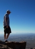
Nevertheless, I did make it through the tough sections of the chute and finally topped out at the small saddle. Unfortunately (or fortunately) the wind was really gusting and as I started up that last leg to the peak, I decided for my safety (!) to call it off---But not before I spied a few lost ladybugs, one landing upon my shoulder.

...After a few pringles, some pics and a couple prayers of encouragement, I started back down. And for the first time in my extensive hiking history I literally had to talk myself off the mountain. The steepness of the chute was much more intimidating looking at it from above than from below IMHO. And after watching a couple loose rocks slipped from under me and fall 500 feet below, I realized that this was personally going to be the safest climb down ever. My greatest anxiety was coming back upon that 15 foot section of near-vertical rock and figuring out the correct way to get past it without falling. And once I solved my foot and hand holds, the anxieties were basically gone.....until the next smaller rock wall. Eventually, with some serious care, I made it back to solid footing and out of the chute. Whew, that was a wild ride.... Now all I have to worry about is that pumpkin, pumpkin, pumpkin, pumpkin El Oso Road with it's wily curves and beautiful views :sweat:

Good luck with this one, fellow hikers. I left a dime on a rock next to the tree with the orange marker on it---It's yours. And for those of you who wish to conquer your fear of heights, stay away altogether.....Go to the local school playground and sit on the monkey bars instead.
Am I disappointed at falling short of reaching the highest peak in Maricopa Cnty? At this point I will be more than happy to glance up at Four Peaks from my yard, sitting in a chair, staying put. :roll:
_____________________
"One foot in front of the other. One foot back to counter it." -From 'Avalanche' by Matthew Good
 
Dec 30 2005
avatar

 Photos 15
 Triplogs 11

56 male
 Joined Dec 06 2004
 Sydney, Austrlia
Boulder Canyon Trail #103Phoenix, AZ
Phoenix, AZ
Hiking avatar Dec 30 2005
vampyroTriplogs 11
Hiking6.50 Miles 400 AEG
Hiking6.50 Miles   3 Hrs   30 Mns   46 Secs1.85 mph
400 ft AEG
 no routesno photosets
1st trip
Linked   none no linked trail guides
Partners none no partners
Picked a wonderful day to hike this trail for the first time ever. Great temps, only a few fellow hikers (even though EVERYONE was driving down the Apache Trail this day), and picture-perfect views. Made it to the creek/stream/river/wash in good time, then decided to work my way back towards Canyon Lake via the wash. Only lasted about a half mile however, as the pickers were cutting my hands and legs something fierce. So I traced my way back to the original trail and returned the way I came. If you do decide to take the wash back, wear some pantalones. :roll:
_____________________
"One foot in front of the other. One foot back to counter it." -From 'Avalanche' by Matthew Good
 
Dec 14 2005
avatar

 Photos 15
 Triplogs 11

56 male
 Joined Dec 06 2004
 Sydney, Austrlia
Camelback Summit - Echo Canyon TrailPhoenix, AZ
Phoenix, AZ
Hiking avatar Dec 14 2005
vampyroTriplogs 11
Hiking2.30 Miles 1,300 AEG
Hiking2.30 Miles   1 Hour   20 Mns   1.73 mph
1,300 ft AEG
 no routesno photosets
Linked   none no linked trail guides
Partners none no partners
42 minutes up without much resting.....Maybe someone gave me my lungs back. I think I'm ready for Everest Base Camp. :)
_____________________
"One foot in front of the other. One foot back to counter it." -From 'Avalanche' by Matthew Good
 
Dec 07 2005
avatar

 Photos 15
 Triplogs 11

56 male
 Joined Dec 06 2004
 Sydney, Austrlia
Flatiron Hike - SuperstitionsPhoenix, AZ
Phoenix, AZ
Hiking avatar Dec 07 2005
vampyroTriplogs 11
Hiking6.50 Miles 2,780 AEG
Hiking6.50 Miles   4 Hrs   45 Mns   28 Secs1.37 mph
2,780 ft AEG
 no routesno photosets
Linked   none no linked trail guides
Partners none no partners
Celebrated Pearl Harbor Day by attempting a solo hike up to that high point above the FlatIron. It's really bothered for the past year knowing that I didn't make my way over to those hoodoos and get to that tallest peak in the front range. So after waiting out the snakes all spring/summer/fall, I finally did make the trek. And it wasn't so easy.

Started out around noon (I like to sleep) and hit Siphon Draw pretty quickly. Brazenly past two elderly couples making their way up, so that inspired me a little. My inspiration went quickly south however as I started up the far canyon to the right. From all the reports I hear, this is the easiest way up, right? Well what about all those loose rocks and 75 degree angles?!? Maybe it was because I scooted over to that easier western plateau route the last time that I was expecting something a little less insane.
Anyhow, it kicked me arse making my way up this canyon. I went up the center and lost my footing more times than I care to admit and nearly landed in one of those hypodermic-needled agaves. Actually, the last quarter mile to the base was the biggest challenge. The rest was doable but not for everyone. And once I found that main trail, things were fine, including that final rockclimb.
Journeying over to the hoodoos to the left and up to the peak was interesting and enjoyable. Watch out for the pickers and rock overhangs and everything is fine. When I finally made it to the top after suffering for one long year, what did I find sitting atop the highest boulder?: A dime. I left a nickle for the collection. Maybe a homeless hiker might be able to use it.... If anyone gets the opportunity, maybe drop a fishbowl off to put all that loose change in.

After lunch, a whiz and some pollution-enhanced photos (thank you East Valley), I started my way back down a little after 3pm. My knees were already buzzing from the steep climb up, so I decided to try and find that easier route along the western ridge and back into the canyon just above the Draw. Well, I lost my way a bit and did some backtracking and some morbid searching for that plane crash sight.....Needless to say, it was about 5pm when I finally circled around and picked up my trail just about the Draw (thank you GPS). Soon after, two guys literally came bouncing down behind me, apparently running from something or just simply playing tag. It was strange to see, considering this is about the last place I would want to prance around in. As quick as they appeared, they ran down through the Draw (not zig-zagging like JoeB. recommends) and were out of sight. Those speed-climbers....God love 'em.

Okay, so it is getting dark, the birds have stopped chirping, and I am still working my way down below the Siphon Draw. I hate the Discovery Trail and it's wicked cholla, but at this point would give anything to be crawling through it about now. The temp has seriously fallen with the sun (surprise) and all I have on is some daisy dukes and a mesh shirt. Not really, yet I'm still beginning to chill. I finally get beyond those wonderful new homes and find my Discovery Trail back to the trailhead. Had to use backlit GPS to find my way that last quarter mile. Total time: 5:30.

Overall, I really think this man SlowClimber is right on: Flat Iron is a bee-ach of a hike (and I've hiked rim-river-rim in one day). The sheer steepness of those upper reaches of that far right canyon is impressive and treacherous. Did I miss the proper trail? Am I overreacting? If we all drove camels would the pollution problem solve itself?
One thing I do know is that I am not about to take this hike alone anymore. And I'd recommend any novice to intermediate hiker unfamiliar with the trails to follow suit. Also, be prepared for some serious hand-grabs, so find some decent gloves (not from Wal-Mart however, they low-ball the competition and we are all for a free-market society based in fairness and equality). And finally, to those of you who constantly try to turn this and every other ultra-challenging hike into some-kind of shallow masculinity contest: You really want to conquer something? Try finding a solution to our ever-growing stray cat problem... :(
_____________________
"One foot in front of the other. One foot back to counter it." -From 'Avalanche' by Matthew Good
 
Nov 10 2005
avatar

 Photos 15
 Triplogs 11

56 male
 Joined Dec 06 2004
 Sydney, Austrlia
Abineau - Bear Jaw LoopFlagstaff, AZ
Flagstaff, AZ
Hiking avatar Nov 10 2005
vampyroTriplogs 11
Hiking7.40 Miles 2,000 AEG
Hiking7.40 Miles   4 Hrs   30 Mns   1.64 mph
2,000 ft AEG
 no routes
1st trip
Linked   none no linked trail guides
Partners none no partners
A very late-autumn hike into this area which, apparently, has been crossed off more than a few people's list because of the 'impassable' conditions which exist on the Abineau trail. First off, let's set the record straight: Abineau is entirely passable (it's time to take down the warning signs). As a matter of fact, I would highly recommend rummaging through this avalanche field which covers the upper parts of the trail. It is a spectacle and honestly allows a person to understand the direction mother nature has upon us.

We trekked up the Bear-Jaw trail on a cool, crisp late morning and returned down the Abineau. A little late for the aspen, a little late for the wild-flowers, a little late for just about everything.....Yet the dramatic views from the top override any disappointment we could have felt. Stopped for lunch just at the the confluence of the waterline and Abineau, with Humphrey's overhead, destruction below, how cool. I'm definitely sticking this one away, maybe pushing it into my top ten after a Spring or earlier Fall visit. :wink:
 Meteorology
 Meteorology [ checklist ]
[ checklist ]  Avalanche
_____________________
"One foot in front of the other. One foot back to counter it." -From 'Avalanche' by Matthew Good
 
Nov 09 2005
avatar

 Photos 15
 Triplogs 11

56 male
 Joined Dec 06 2004
 Sydney, Austrlia
Boynton Canyon Trail #47Sedona, AZ
Sedona, AZ
Hiking avatar Nov 09 2005
vampyroTriplogs 11
Hiking5.00 Miles 685 AEG
Hiking5.00 Miles   3 Hrs   10 Mns   28 Secs1.58 mph
685 ft AEG
 no routesno photosets
1st trip
Linked   none no linked trail guides
Partners none no partners
First hike into the famous (or is that now infamous) Boynton Canyon. My first, last and everything in-between impression during the trek: What an absolutely wonderful hike this would be if we didn't have to stare out upon the Enchantment Resort compound.... Talk about an eye-sore! Don't get me wrong, the resort looks very nice and I'm sure all their birkenstock and black-sock visitors are extremely kind....But, damn, if that place doesn't ruin a perfectly good hike.

I did appreciate the contrast between the first and last parts of the hike. The initial mile or so is full of fantastic desert landscape (or is that xeriscape) and the final mile is a nice stroll through a decidedly undesert-like forest. And my doesn't it cool off once you get into the meat of the canyon. Sweatshirt, no sweatshirt, t-shirt, sweatshirt, t-shirt, no sweatshirt....The whole journey was like I was playing on the Def Leppard Pyromania tour. One night Joe Elliott, er Vampyro is wearing his Union Jack parka, the next night he's barebacked (so to speak), the following night he's in his Union Jack sleeveless tee. BTW, I wish the people of Columbia or whomever would introduce a sweatshirt with unzippable sleeves...That would be really cool.

Anyhow, my final opionion of Boynton Canyon after all is said and done and I've had a few moments to reflect: A great red-rock experience for those experiencing it for the first time. For those of us who have been around the rocks and are a little more solitude-hungry, try something else in the area. I know I will. :?
_____________________
"One foot in front of the other. One foot back to counter it." -From 'Avalanche' by Matthew Good
 
Nov 07 2005
avatar

 Photos 15
 Triplogs 11

56 male
 Joined Dec 06 2004
 Sydney, Austrlia
West Fork Oak Creek Trail #108Sedona, AZ
Sedona, AZ
Hiking avatar Nov 07 2005
vampyroTriplogs 11
Hiking6.00 Miles 200 AEG
Hiking6.00 Miles   4 Hrs   15 Mns   14 Secs1.41 mph
200 ft AEG
 no routesno photosets
1st trip
Linked   none no linked trail guides
Partners none no partners
Long pretty hike; nice rocks.
_____________________
"One foot in front of the other. One foot back to counter it." -From 'Avalanche' by Matthew Good
 
Jan 12 2005
avatar

 Photos 15
 Triplogs 11

56 male
 Joined Dec 06 2004
 Sydney, Austrlia
Piestewa Peak Summit Trail #300Phoenix, AZ
Phoenix, AZ
Hiking avatar Jan 12 2005
vampyroTriplogs 11
Hiking2.40 Miles 1,200 AEG
Hiking2.40 Miles   1 Hour   20 Mns   1.80 mph
1,200 ft AEG
 no routesno photosets
1st trip
Linked   none no linked trail guides
Partners none no partners
Saw a giant lizard.
_____________________
"One foot in front of the other. One foot back to counter it." -From 'Avalanche' by Matthew Good
 
Dec 11 2004
avatar

 Photos 15
 Triplogs 11

56 male
 Joined Dec 06 2004
 Sydney, Austrlia
Flatiron Hike - SuperstitionsPhoenix, AZ
Phoenix, AZ
Hiking avatar Dec 11 2004
vampyroTriplogs 11
Hiking5.40 Miles 2,780 AEG
Hiking5.40 Miles   5 Hrs      1.08 mph
2,780 ft AEG
 no routesno photosets
Linked   none no linked trail guides
Partners none no partners
A great hiking day, relatively clear sky, about 60 degrees, only ran into 4 people the whole time. My first time, great directions guys. Missed my 'trail' back down however and ended up descending the dreaded 2nd canyon :o Kind of like walking on marbles while doing the Curly Shuffle, but I made it. Wow, did my toes hurt after!

Two things: That final wall near the top is 8.5 feet high. Also, don't urinate on an upslope.
_____________________
"One foot in front of the other. One foot back to counter it." -From 'Avalanche' by Matthew Good
 
Dec 08 2004
avatar

 Photos 15
 Triplogs 11

56 male
 Joined Dec 06 2004
 Sydney, Austrlia
Camelback Summit - Echo Canyon TrailPhoenix, AZ
Phoenix, AZ
Hiking avatar Dec 08 2004
vampyroTriplogs 11
Hiking2.30 Miles 1,300 AEG
Hiking2.30 Miles   1 Hour   40 Mns   1.38 mph
1,300 ft AEG
 no routesno photosets
Linked   none no linked trail guides
Partners none no partners
_____________________
"One foot in front of the other. One foot back to counter it." -From 'Avalanche' by Matthew Good
 
Nov 28 2004
avatar

 Photos 15
 Triplogs 11

56 male
 Joined Dec 06 2004
 Sydney, Austrlia
Camelback Summit - Echo Canyon TrailPhoenix, AZ
Phoenix, AZ
Hiking avatar Nov 28 2004
vampyroTriplogs 11
Hiking2.30 Miles 1,300 AEG
Hiking2.30 Miles   2 Hrs      1.15 mph
1,300 ft AEG
 no routesno photosets
Linked   none no linked trail guides
Partners none no partners
My initial foray into the Phoenix hiking scene. Great, scenic and exhausting (for my out of shape body) experience. Going again next week! :)
_____________________
"One foot in front of the other. One foot back to counter it." -From 'Avalanche' by Matthew Good
 
average hiking speed 1.48 mph

WARNING! Hiking and outdoor related sports can be dangerous. Be responsible and prepare for the trip. Study the area you are entering and plan accordingly. Dress for the current and unexpected weather changes. Take plenty of water. Never go alone. Make an itinerary with your plan(s), route(s), destination(s) and expected return time. Give your itinerary to trusted family and/or friends.

helpcommentissue

end of page marker