|
| | | |
| |
|
| Hiking | 34.00 Miles |
7,000 AEG |
| | Hiking | 34.00 Miles | 55 Hrs | | 4.86 mph |
| 7,000 ft AEG | 2 Days Break | 60 LBS Pack | | |
|
|
| |
| Partners |
|
none
[ show ]
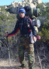
| no partners | | This was my first backpacking trip into the Rincons, and I did it solo since I didn't have many friends who were quite as crazy. It was a 3 day 2 night trip, with the first and last days spent heading to Juniper Basin, while day 2 was a day hike to Manning Camp. I turned around a little short of Manning camp though, which I'll explain later.
Day 1 was the toughest, carrying a loaded pack on a non stop climb all the way up Tanque Verde Ridge. I needed very frequent stops, but every stop gave an increasingly better view of Tucson and the surrounding mountain ranges. The first mile or so is the steepest as you head up to the first ridge. It turns to easier rolling hills after you hit the grasslands at about 4000ft,although its still a constant elevation gain. (I didn't use a GPS, so all these elevation numbers are estimates) With the warmer than normal winter this year, all the springs were flowing well, so there's no shortage of water.
Day 2 started off later than I expected, as I waited for the sun to rise to warm myself up, which I later realized was just not necessary as I would get warmer much quicker if I just started moving. It was just below freezing during the night, by the way. Probably 30 degrees, another rough estimate. The climb to Tanque Verde Peak gets steep about 1 mile before and after the peak, though still not too bad. As usual, the views are stunning in all directions. I'll let the pictures elaborate on that point. The trail gets a little overgrown after the peak, and the biggest pain was the thorn bushes that grow outwards into the trail and all directions, making it impossible to avoid. I didn't care so much about the cuts that I got, but I wanted to avoid them snagging onto my backpack as they were strong enough to rip tears in it.
After losing significant elevation and arriving at Cow Head Saddle, its all uphill again to Manning camp. The trail is very well maintained here, being much wider and with lots of rock steps leading up the steeper sections. It didn't take long to reach the pine forest, and there was much less snow than I expected, even in the warm weather. Apart from a few patches, there was almost no snow at all covering the trails. The streams were flowing strong as well. Unfortunately, with my late start and the early sunset, I had to set a cut off time for myself to turn back, and less than a mile away from Manning camp, I made the tough choice to turn back. With the clouds rolling in, I didn't want to take any chances. With most of my food consumed, I could fly back down the trail and back to camp. And, as foreshadowed by the clouds that evening, it did snow at night, with significant winds blowing. Thankfully, the trees provided adequate shelter from the elements, and the winds barely reached my tent.
Day 3 was the easiest, with just a little water and food left reducing my pack's weight by nearly half, it was all downhill back to the trail head. I did start off earlier by layering more the night before, so I didn't need to warm up with a fire or wait for the sun. The return journey was fast and easy, and I met the first other people after 2 days alone, about 2 miles away from the trail head. Being a weekday, there wasn't many other hikers out, so it was a nice and quiet return to civilization.
I'm already planning for the next time I do this hike, although I would probably approach it from the Douglas Spring trail next time so that I can spend more time exploring the top of Mica Mountain, which was my initial intention for this trip. |
|
Wildflowers Observation Isolated
|
|
  |
Manning Camp Spring |
Gallon per minute |
Gallon per minute |
| | | All streams atop Mica Mountain are flowing well with lots of melting snow. | | _____________________
| | |
|
|
|
 Route Editor