 Route Editor

| Guide | ♦ | 22 Triplogs | 0 Topics |
details | drive | permit | forecast | 🔥 route |
stats |
photos | triplogs | topics | location |
| 0 | 22 | 0 |
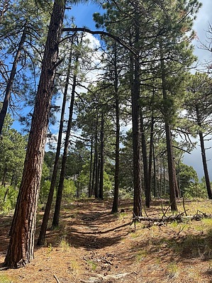
No cows, just views... by Jeffshadows   Cow Head Saddle Trail is a backcountry connector trail located along the northwestern ridge of Mica Mountain in the Rincon Mountains. It emanates from Cow Head Saddle and terminates just above Manning Camp into the Mica Mountain Complex of trails. Along its 3.9 mile course, it gains just shy of 2,000' and provides truly unique views of prominent features that truly cannot be had elsewhere. This description assumes an ascent. Cow Head Saddle Trail is a backcountry connector trail located along the northwestern ridge of Mica Mountain in the Rincon Mountains. It emanates from Cow Head Saddle and terminates just above Manning Camp into the Mica Mountain Complex of trails. Along its 3.9 mile course, it gains just shy of 2,000' and provides truly unique views of prominent features that truly cannot be had elsewhere. This description assumes an ascent.Cow Head Saddle is a natural confluence and is frequently host to running water in wetter months. The trail that bears its name begins to climb immediately after dipping south and turning sharply north to avoid a minor highpoint along the ridge whose course it uptakes. This pattern of winding around highpoints repeats itself continuously along the lower stretches of the trail. The course of the trail is sandy here and you are as likely to encounter steps in the form of a large root from a nearby oak as you are to encounter those comprised of sandy rock. The trail climbs relentlessly as it seems to senselessly wind around obstacles, but pays you back in spades along this lower section in the form of amazing views. The views of Redington pass and the eastern Catalinas are a sight to behold, but the real gem is the unusual view of the north slope leaving Tanque Verde Peak. This is a view you are not likely to get even from the Manning Camp trail, and it provides an excuse to stop and take an occasional break from the climb. In wetter months, this section of trail may host a stream course or a very muddy track.
Now, after about three miles, the trail enters the basin of a shady canyon dominated by a tall pine canopy and begins to follow its watercourse. This welcome oasis boasts ferns and small waterfalls, though it is likely to be dry in the summer. The ascent ceases for a while as the track dances back and forth across a small stream in a fine specimen of Sky Island pine forest. The trail then begins to climb the bank of the valley and views of Helen's Dome become increasingly magnificent as the trail now follows a pine cone-laden, sandy course over and around rock outcroppings. As the trail passes by Helen's Dome, it makes a final rolling ascent onto a minor ridgeline where it meets its junction with the Fire Loop and North Slope trails. Manning Camp is less than a mile away along the Fire Loop trail.
Check out the Official Route and Triplogs. Leave No Trace and +Add a Triplog after your hike to support this local community. One-Way Notice This hike is listed as One-Way. When hiking several trails on a single "hike", log it with a generic name that describes the hike. Then link the trails traveled, check out the example. | |||||||||||||||||||||||||||||||||||||||||||||||||||||||||||||||||||||||||||||||||||||||||||||||||||||||||||||||||||||||||||||||||||||||||||||||||||||||||||||||||||||||||||||||||||||||||||||||||||||||||||||||||||||||||||||||||||


