|
| | | |
| |
|
| Hiking | 21.56 Miles |
3,373 AEG |
| | Hiking | 21.56 Miles | 15 Hrs | | 10.78 mph |
| 3,373 ft AEG | 13 Hrs Break | 40 LBS Pack | | |
|
|
| |
| Linked |
|
none
[ show ]
| no linked trail guides |
| Partners |
|
none
[ show ]
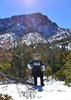
| no partners | | So much for a 3 day nice hike to river and back.
First important note...we second the triplog of the previous post that the FS map is NOT accurate...it is not 7 miles from trailhead to river.
We parked just outside the private property(ranch) and hiked up to the trailhead. The worn down and bullet busted sign should have been our first clue, but we have seen trailheads worn and torn before and weren't phased.
The cairns, petrified horse poop, cattle hoof prints, and some worn ground/jeep road tracks are the only things that notify you that you're on the trail. A close watch to the turns of the cairns(some we built up because you could not see from one to the other without a good search) is important. The trail is rough...VERY rocky...hardscrabble mesa is a perfect description. The view is plain...except for the wildlife! We were a few feet from at least 4 elk, white tailed deer several times along the trail or off in the distance, coyote, and jack rabbits.
After a dip down into a boulder-canyon...you are only roughly half-way. It's still a couple miles after this that you actually get the first glimpse of the river. We were 70% out of water by this view and with water in sight, we went for it. We did not see any signs indicating the connection with Deadmans trail or the distance to the river. It was the heat of the day and as we descended...it kept heating up.
The descent to the river is steep and cautious footing is a must. The steep descent is combined with loose rock...very hard going with tired legs. One slip & a sprained ankle quickly brought thoughts of how this could be a survival issue. The river definitely takes you in, because around each turn we knew we were closer, but from the view of the river to the actual riverbed is approximately 2 hours of hiking.
When we got to the river, we filtered water and jumped into the river. Our dog(Chesapeake Bay Retriever) booked it down the trail and jumped in before us. The river was refreshing and approx. 5 ft deep in some parts and plenty of it's own wildlife(caught a crayfish near the rapids).
We camped overnight on the riverbed with the mission to get back to the car the next day. Camping anywhere else along the trail would have been a waste of water. We were exhausted already and just ready to be off this trail.
We filtered water to fill every platypus and camelback we had. The first 2 hours were brutal. Steep incline with 40 pd packs after 11 miles the day before. We hiked 2 hours and stopped to take off our packs, eat a protein bar, bandage our feet, and then hiked another 2. The hike back on this trail is essentially all incline. Some parts steeper than others, but all incline.
On our way back through the mesa we lost the trail in a couple places, but with eagerness to get back to the car and the little brain-power left, we managed to track back to the cairns...back to the trailhead...and back to the car! 7 hours to river....8 hours back. Adventure not to be forgotten, but a few lessons learned:
*The maps you read may not always be accurate and certainly do not account for types of terrain. Planning for a hard hike and having it be easy is better than planning for an easy hike and well...
*Build up cairns along the way! It certainly helped to have higher cairns and gave us certain landmarks we remembered because we stopped to build them up.
*Making mental notes of different landmarks(when not watching your step) was helpful especially when our bodies were wearing down.
*Check websites(like this one!) before going out to get an actual account for the hike rather than just maps and FS info. |
|
Wildflowers Observation Light
|
|
| _____________________
| | |
|
|
|
 Route Editor