username
X
password
register
for free!
help
ArticlesGuidesRoutes
 
Photosets
 
 Comments
triplogs   photosets   labels comments more
3 triplogs
login for filter options
Dec 01 2012
avatar

 Photos 17
 Triplogs 3

45 female
 Joined Apr 02 2012
 Tucson, AZ
Cochise Stronghold Trail #279Tucson, AZ
Tucson, AZ
Hiking avatar Dec 01 2012
RingwormTriplogs 3
Hiking9.50 Miles 1,100 AEG
Hiking9.50 Miles
1,100 ft AEG
 no routes
1st trip
Linked   none no linked trail guides
Partners none no partners
Did this trail as a nice little 2 day 1 night backpacking trip. It was the first time I'd taken my dogs on an overnight. Also, I had a good friend (a climber) in town, so this sounded like the perfect marriage of my hiking love with his bouldering love.

Day 1
Things started out rough--the dogs locked themselves and my keys in the car when we stopped to pay the day use parking fee at the east TH campground. The car had the sun directly on it and no windows were open. Terror for my terriers! Luckily there were some very nice snowbirds staying in the campground--traveling with wire hangers and a small dog of their own. They took pity on us and helped to get the car unlocked. It still took about 45mins to free the little suckers... another 20mins and I fear I would have had to break a window. Yeeesh. Once they were free we paid the fee for two days of day use parking, hit the bathrooms, and took off down the trail.

When researching this trail I paid more attention to the length and the description of how easy the trail is to navigate. I didn't really pay too much attention to the descriptions which labeled the climbs as tough... and they were, but they were not too bad. On day one (going east to west) it is a slow and steady climb up to the plateau and divide. The trip down to the west TH and "camping" area is quick with a lot of loose gravel and dirt in deep ruts, presumably caused by years of use by hikers and hooves alike. The boulders called my friend's name, but he'd have to leave them for the next day--we wasted any extra time we had for scrambling around on rocks trying to free the dogs from the car.

We reached the west "campground" just before nightfall. I was surprised, but there were 5 cars that I counted parked in the various rudimentary "spots." There was also a little bit of trash and I even found an opened uneaten can of beans--the stupidity of people never ceases to amaze me, as I had seen numerous piles of bear scat just off the trail at various altitudes along the hike. We found a good tree for our bear bag, a nice pile of soft leaves a fair distance away from the cars, and set up our little camp. The pooches were ready to eat some dinner and after they were full they settled down into the night. We had a tent because we weren't sure how cold it would get--in the end we were all perfectly warm with the rain fly secured and our +20 and +10 degree bags. I don't think it got under 35, maybe even 40, the whole night.

Day 2
We headed out of the west camp at around 9am, having gotten a very nice night's sleep. The dogs were just as frisky as they had been the day before, and they seemed much less daunted by the idea of the short intense climb up to the divide on the way back. As it turned out, although the climbing was tougher, we both decided we preferred it to the day before, but that might have been the combination of doing it in lower temps and with lighter packs (we had to carry in all our water, as the tank is dry at this time of year). The views of Rockfellow Dome are CERTAINLY better and more majestic when approaching from the west--that probably helped distract us from our huffing and puffing. We also saw a cocoon for what might have been praying mantis just near the overlook that is about 1/4mi from the divide gate on the east side. There's a photo of it in the photoset--does anyone know if that's what it looks like?

My friend finally got in some bouldering when we were about 1.2mi from the east TH. The dogs and I took a break and watched him chalk up and climb. The rest of the hike back was leisurely and peaceful. The pups started to lag behind, the midday heat started to get to them. When we arrived back at the east TH and campground, they jumped into the car pronto and passed out.

On our way back to Tucson we attempted to stop in Benson and try out Apple Farm, but they closed just as we pulled up. We settled on the Mexican place down the street and the dogs zzzzzzzzzzzzzz-ed it away in the car without a peep. All in all it was a really great way to spend 24hrs in a short weekend away from Tucson!
_____________________
 
Sep 28 2012
avatar

 Photos 17
 Triplogs 3

45 female
 Joined Apr 02 2012
 Tucson, AZ
Aravaipa CanyonGlobe, AZ
Globe, AZ
Canyoneering avatar Sep 28 2012
RingwormTriplogs 3
Canyoneering11.00 Miles 200 AEG
Canyoneering11.00 Miles3 Days         
200 ft AEG
 no routes
1st trip
Linked   none no linked trail guides
Partners none no partners
When I checked for BLM passes in August, there were only a couple left for the weekend and only for the East Entrance. Having never done Aravaipa before, I figured either side was a good place to start, as I just wanted to get into that water and splash around! My wife was game, so we planned the trip for the last weekend in September.

Day 1
We got (almost) to the confluence of Turkey Creek and Aravaipa Creek around noon on Friday. The last creek crossing just before the confluence is a dead drop-off and our subaru would have died a slow painful death had we kept going. We parked just off the road up against a Nature Conservancy cable/sign. . . not sure if that was kosher or not, but the car was there when we returned without a nasty note or anything.

Since we'd both never been, we started off with no plan for how far we'd go or what we'd do. We essentially just wanted to take the whole place in and plan for many return trips. That's what ended up happening. We made it as far as the opening of Hell Hole Canyon the first afternoon and decided to make camp. After a small issue with the bear bag (I brought a spool of measly twine instead of sturdy rope and heard about this all weekend), we tucked in for a cool fall night's sleep with an almost full moon bouncing lovely shadows and pale light off the canyon walls. We didn't cowboy because there were enough bugs to warrant some sort of tent. It did get a little too chilly for our +55 sleeping bag liners, but it wasn't so uncomfortable that we missed any sleep over it. We could have probably put the rainfly on, but the view out the top of the tent onto the canyon walls was too great to be sacrificed for a little warmth.

Day 2
We had plans to explore up Hell Hole the next morning and then try to go further downstream into Aravaipa in the afternoon. Instead, we woke up at 5am to pee, thought we'd go back to sleep just for an hour or so and then get up and hit Hell Hole. NOT SO! I shot awake at the worm-getting time of 10am! Shameful. So we decided to take it easy around camp, read, eat brunch, and then set out down Aravaipa. We were sad not to explore Hell Hole, but as I said, we had come to Aravaipa this first trip just to take it all in and plan for future ones. Top of the list next trip--Hell Hole, obviously.

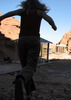
We spent the rest of the day splashing down the creek sans backpacks, but with only our bladders full and no filter in our little waist packs, we only made it another mile and a half down creek. There was plenty of splashing and sitting in the water to be had. Mostly we just snapped lots of photos and marveled at how beautiful it really is.

We ended up eating something like 8 marshmallows each that night in a successful attempt to finish all that we brought. The moon was even brighter, and what with so much sugar (and some unexplained stuffiness on both our parts even though neither of us suffers from allergies), we each took a benadryl and passed out.


Day 3
Mindful of our very late second wake up from the morning previous, we made sure we actually got moving when the 6am morning pee hit us. We took our time though eating breakfast and packing up. We were both loathe to leave the canyon and to strap our packs back on, even though the hiking is so easy in Aravaipa. We hoofed it outta there by 9:30am. Real hunger set in halfway between Aravaipa and Wilcox, but we held it off until the Mexican place in Benson. Nothing to rave about, but cheesy and hot hit the spot!

The only real complaint for the whole trip was that we didn't see any wildlife!! I kept a squinted eye on the cliffs scanning for bighorn the whole time and nary a one. No bear, no lions, etc. Sad! All the more reason to go back asap! We saw only two other people the whole time on our hike, and they were just day hiking in from the East TH in our last 20 minutes on the trail. Overall our experience was picturesque, tranquil, amazing. As my wife said a day after our return--"That place was life-altering." I think after living in the desert now for over a year, we've truly come to appreciate the wonder of running water in a way that non-desert-dwellers can never understand. Can't wait to get back!
 Fauna
 Fauna [ checklist ]
[ checklist ]  Canyon Tree Frog
_____________________
 
Apr 28 2012
avatar

 Photos 17
 Triplogs 3

45 female
 Joined Apr 02 2012
 Tucson, AZ
Tanque Verde Ridge TrailTucson, AZ
Tucson, AZ
Hiking avatar Apr 28 2012
RingwormTriplogs 3
Hiking13.80 Miles 4,300 AEG
Hiking13.80 Miles   10 Hrs   15 Mns   1.35 mph
4,300 ft AEG37 LBS Pack
 no routesno photosets
1st trip
Linked   none no linked trail guides
Partners none no partners
Did this out and back up to Juniper Basin as an overnight. I got a late start around noon on the 27th. Took me 6hrs 15mins to hoof it up the trail with a heavy pack full of water (there was no water at Juniper Basin that I could find, so I was glad I took so much). It was a lovely weekend for a hike--in the mid-70's at the TH. The sun was shining strong and there was very little breeze, so it did feel a tad hotter. Still, it was lovely. Passed maybe only 4 day hikers on my way up; they were all on their way down. Cached some water 1/3 and 2/3 of the way up. The trail was very very well marked with cairns--I think I only got a few feet off in the wrong direction a couple of times before realizing that I should backtrack and find a trusty pile o stones.

Juniper Basin was lovely and just the right brand of solitude. Not a soul to share the little forest-like spot with, and just enough light left to pitch the tent and start a fire. I had planned to make it to up to the peak but a sick cat and trip to the vet in the morning derailed those plans. It was very cool at night--think it got down to mid 30's, at least I could see my breath at 5am when I got up and I know that it got down to 40 3,000ft below. I couldn't tell since I busted out my +10 down in anticipation.

I trucked up out of the little camp at 8am and was back down the trail by noon--exactly 4hrs to make my way. I passed one solo dayhiker on her way up probably only a half mile from Juniper Basin--talk about an early bird getting the worm! My first water cache was empty when I came upon it (evil little critters had chewed their way right through the plastic) and I blew past the second one without even knowing it! I was out of water for the final miles, but luckily it was another lovely day with temps no higher than the mid 70s.

I passed a couple of backpackers on their way up when I was in my last mile or so. They had the same schedule and plan that I had had the day before. I do think they might have had more water than I did and no doubt if they were caching they were smart enough to use critter-proof containers. I'm sure they spent less time cursing than I did!
_____________________
 
average hiking speed 1.35 mph

WARNING! Hiking and outdoor related sports can be dangerous. Be responsible and prepare for the trip. Study the area you are entering and plan accordingly. Dress for the current and unexpected weather changes. Take plenty of water. Never go alone. Make an itinerary with your plan(s), route(s), destination(s) and expected return time. Give your itinerary to trusted family and/or friends.

helpcommentissue

end of page marker