|
| | | |
| |
|
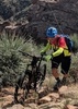
| Biking - Mtn | 3.90 Miles |
2,467 AEG |
| | Biking - Mtn | 3.90 Miles | | | |
| 2,467 ft AEG | | 40 LBS Pack | | |
|
|
| |
| Linked |
|
none
[ show ]
| no linked trail guides |
| Partners |
|
none
[ show ]
| no partners | | This was a somewhat exploratory 'adventure' mountain biking route a friend of mine had planned. A counter clockwise loop up Park Trail and then onto another trail, which we never made it to, due to Park being such a mess. We were loaded out for a day trip, no camping gear. We parked at El Oso road and rode our bikes a few miles north to the dirt road that leads to Park Trail. We had a GPS track from a hiker and a USGS topo map in Gaia GPS. This trail requires quite a bit of wayfinding past the saddle. The first 1/4 mile of the trail, we rode, dodging rocks and cow patties. We trimmed a few bits of cat's claw on some switchbacks. The trail was mostly clear up to the saddle. Very steep, so we pushed the bikes up as expected after that first bit. Keeping an eye out for cairns helped in a few spots where the trail was overgrown with grasses.
We made it to the saddle easily almost entirely on foot. After a short break, we set off on what looked like the trail. After a few minutes we discovered this was not the trail and walked up the hill a bit to get back on something that looked a bit more usable. Already pushing between bushes at this point and lifting bikes to get back on trail. Red flags. After making the first right hand turn to contour the hillside the trail further deteriorated and we continued pushing through bushes that encroach on the trail or completely block the trail, hoping that getting off the northern exposure would lead to less dense growth. This continued on for several hours, sapping our energy and scratching at our legs. The track we had downloaded was from a hiker - maybe he got lost as well. The USGS map helped quite a bit. When the track and USGS agreed, we made our way toward them to rejoin the sorry excuse for a trail.
GPS said .6 miles to jeep road, which would lead us out. We were determined not to walk back down the steep part of Park and pushed through, eventually climbing our way out of a tangle of bushed, up a rock and onto the trail for perhaps the fifth time! The trail emerged from the thick growth on a grassy hilltop and a view of ponds and the creek. I was able to ride about 50 yards downhill to the ponds where I filtered water and gave the feet a rest while emptying shoes of bits of grass and rocks. We found the 'trail' again and then the trail head sign. It took us about 5 hours to get to this point from the bottom. We didn't have much time to enjoy the destination as it was 3PM with sunset rapidly approaching and we had a long way to go. We enjoyed amazing views of Tonto Basin, the superstitions and sunset over the valley on the way back to the car.
We rode the jeep road to the AZT back to the base of El Oso Road in another 3.5 hours for a 32 mile loop around 9 hours. Park trail needs some work to be cleared out for a pleasant hike. The lower part needs to be re-routed for riding. If the part after the saddle was cleaned out, it could be ridden or easily hiked. The views are great and the parts of the trail we walked had good tread. Cell service is available for much of it. There are cairns on the trail, which help, but reading previous reports, someone had built cairns on alternate routes to the creek or waterfalls, so don't rely on cairns. I wouldn't wear shorts and would encourage gaiters to keep the grass out. Have fun! |
| | |
|
|
|
 Route Editor