Route Editor

| Guide | ♦ | 59 Triplogs | 10 Topics |
details | drive | permit | forecast | route |
stats |
photos | triplogs | topics | location |
| 609 | 59 | 10 |
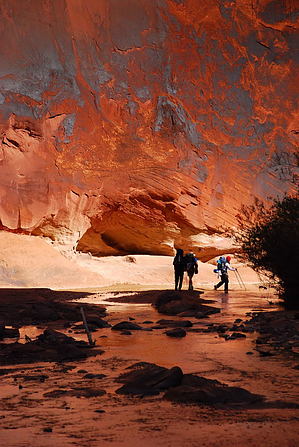
Canyons are inherently risky. Flash floods occur without notice on sunny days. Technical skills & surrounding topography knowledge required yet does not eliminate risk.
Muddy Water Canyon by hill180  On your way to Buckeye or the White House trailhead you will pass many natural wonders and great day hike areas. Betty (our shuttle driver) pointed many out which we would have missed otherwise. In Marble Canyon there are two nice restaurants to visit once you have completed your hike, not hard to find since it's a small and very friendly community.
We started at White House entrance wide open canyon which closes quickly to narrow passages very beautiful. From 12 miles in you start running into natural springs which you can drink from. I don't recommend the river water though. You will have springs every so often until 25 miles in. The last spring is 13 miles from the end of the trail so if you are low on water be sure to load up because the last 13 miles of the canyon opens up again and it becomes very hot and there is very little shade. You will do a lot of walking in the river so if you can keep dry as long as you can good luck. Even though the canyon becomes narrow there are a lot of great camping spots. Be sure to camp high in case of flash floods. Note Besides the great hikes in this area there is a lot of history and the people here are more than glad to tell you about it so don't be shy to ask. Many movies were filmed here; westerns, Evolution, and a lot of others you will have to find out when you talk to the locals. I got off the hike a bit but there is so much in this area to see. The hike was the Climax of what we saw, heard and experienced.
BLM Division Details Paria Canyon offers a challenging and enjoyable 38-mile hike for a well-prepared hiker. For ill-prepared hikers, it can become an exercise in survival. Four to five days are recommended to hike from White House Trailhead to Lees Ferry. Please be aware of the Visitor Use Regulations for the area. (Further Down) Hiking conditions change in the canyon with the seasons. During the popular spring season, plan on hiking in water ankle-to-knee deep. During May and June, the Paria River can be dry for the first seven miles, with the remainder below the Buckskin Gulch confluence flowing year round. This hike can be extremely strenuous and hazardous during months prone to flash flooding. For several days after a flood expect quicksand and mud to make hiking more difficult. Generally, the route through Paria Canyon is the river bed itself; however, at Mile 28, large boulders clog the river, obstructing this way. Most hikers leave the river at this point and follow a route on the right (south) side of the stream where some scrambling through boulders is required. Choosing to follow the river through this section may not be possible during periods of higher water, and requires negotiating a route through many pools and over large boulders. Hiking in the lower canyon consists of traversing long silt terraces or benches with fewer stream crossings. The long-term or 14-day parking lot at Lees Ferry is reached by staying in the riverbed past the registration box at Mile 38. The visitor rules apply to the Paria Canyon, Buckskin Gulch, and Wire Pass portions of the Paria Canyon-Vermilion Cliffs Wilderness, AZ-UT. The objectives of the rules are to prevent further damage to wilderness resources and to improve visitors' opportunities to enjoy the area. The rules represent the minimum level of visitor management needed to accomplish those objectives. Check out the Official Route and Triplogs. Leave No Trace and +Add a Triplog after your canyon trip to support this local community. | |||||||||||||||||||||||||||||||||||||||||||||||||||||||||||||||||||||||||||||||||||||||||||||||||||||||||||||||||||||||||||||||||||||||||||||||||||||||||||||||||||||||||||||||||||||||||