Route Editor

| Guide | ♦ | 16 Triplogs | 1 Topic |
details | drive | permit | forecast | route |
stats |
photos | triplogs | topic | location |
| 108 | 16 | 1 |
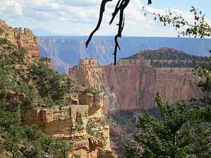
Spring along the Cliff by Dschur  Cliff Spring Trail is a delightful short steep trail that winds down from the road and an overlook of Angel's Window. The trail starts on the other side of the pull-off, just a little ways from the end of the Cape Royal Road. There is a spot with enough room for 3 or 4 cars to pull off. Cliff Spring Trail is a delightful short steep trail that winds down from the road and an overlook of Angel's Window. The trail starts on the other side of the pull-off, just a little ways from the end of the Cape Royal Road. There is a spot with enough room for 3 or 4 cars to pull off.The trail takes off next to a sign. Just a little bit down the trail is a Granary that is signed. The trail then wanders down a creek bed through the Ponderosas. Here it gets a little rocky, so watch the footing. It crosses back on the north side and starts along the cliff face. There is an overhang of Coconino sandstone with fine sand lining the trail. There the sun shines off the other side and lights up the cliffs. You will start to see into the main canyon, looking down this side canyon. As you walk along the cliff, you come to the spring. The water drips down the sandstone and pools on the cliffside under the overhang. The spring isn't the prettiest, but it is always neat to see water anywhere in Arizona. There are handprints on the side of the wall here, but they are the works of modern-day people and not ancient Arizonians. You can continue just a little bit farther on the trail but ends up quickly.
You go back up the same trail to the trailhead. Don't forget to view Angel Window before you drive away. Check out the Official Route and Triplogs. Leave No Trace and +Add a Triplog after your hike to support this local community. | |||||||||||||||||||||||||||||||||||||||||||||||||||||||||||||||||||||||||||||||||||||||||