Route Editor

| Guide | ♦ | 127 Triplogs | 4 Topics |
details | drive | no permit | forecast | 🔥 route |
stats |
photos | triplogs | topics | location |
| 751 | 127 | 4 |
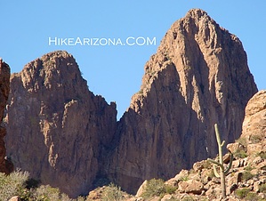
Nice desert trail! by joebartels   Overview OverviewThis is a popular loop through Barkley Basin, rounding Miner's Needle and back on the Bluff Spring Trail #235. The kicker is a short off-trail jaunt to a breathtaking view of Weaver's Needle! Route Dutchman #104, Bluff Springs #235, a short jaunt on Terrapin #234, some easy off-trail to a nice view of Weavers Needle, back on the Terrapin #234, complete loop back on Bluff Spring #235.
From the Peralta head out east following the Dutchman #104. After passing the beginning hills the trail drops down into Barkley Basin. It's a nice stroll across. Passing the junction with Coffee Flat Trail #108, the trail starts to switchback. Once you make it through the five or six switchbacks you start heading northwest. Soon you will pass the right side of Miners Needle. Passing the north end you get a great view through the eye of the needle. The eye is small so don't get too excited. The trail makes a quarter circle around Miners Needle then heads north again. Shortly you come to the junction with Whiskey Spring Trail #238 at about four and a quarter miles. Continue on the Dutchman #104 down to Bluff Springs #235. Take Bluff Springs #235 west to the junction with Terrapin #234. Most head on back to the parking lot, which is 2.3 miles away. I can't imagine coming this far and going home. Weavers Needle is fairly close with awesome views. Plus there is an option to make this an even bigger loop over to the Peralta or Cave Trails. Head across the flat creek bed and up Terrapin Trail #234. Keep your eye on the trail. It's faint in sections but nothing to worry about if you pay attention. You have a couple of options. The easiest is to just follow the Terrapin until Weavers is directly west of the trail. The view is pretty awesome. This is also the best option if you are feeling tired. Your other option is to continue, but stop before the knoll on your left that's blocking part of Weavers Needle. Be forewarned this isn't gonna be easy and forget it if you're tired. Okay, you need to head up the ravine on the south side of the knoll. Your task here is to plan. You need to make it to the saddle to look head-on to Weavers Needle. Weavers Needle is northwest from the saddle. You'll be so disoriented you'll think it's due north, but it isn't. So look ahead and find the easiest line to travel. This is it. In my opinion, this is the best view of Weavers Needle. From here you have two options again. The mileage given above is up to this point and back to the trailhead on Bluff Springs Trail. So head back to the Terrapin/Bluff Springs junction. Take a right and follow Bluff Springs #235 2.3-miles back to the trailhead. There is one section where the trail turns into a slide rock stream bed. After a short bend to the right, the trail picks back up. If you should happen to run the whole loop clockwise (what most consider backward in this case) be sure to follow the slide rock around the bend. If not you'll end up in Barks Canyon and way over your head. The other option is to head down into the valley in front of Weavers Needle and cross over to the Peralta Trail. You need to scramble up the saddle south of Weavers Needle. From the saddle, you take the ravine back down to the Peralta Trail. Head southeast on the Peralta Trail up to Fremont Saddle. You can continue on the Peralta Trail or take the Cave Trail back down to the trailhead. Keep in mind this is one heck of a loop hike. Check out the Official Route and Triplogs. Leave No Trace and +Add a Triplog after your hike to support this local community. | ||||||||||||||||||||||||||||||||||||||||||||||||||||||||||||||||||||||||||||||||||||||||||||||||||||||||||||||||||||||||||||||||||||||||||||||||||||||||||||||||||||||||||||||||||||||||||||||||||||||||||||