Route Editor

| Guide | ♦ | 196 Triplogs | 0 Topics |
details | drive | permit | forecast | route |
stats |
photos | triplogs | topics | location |
| 659 | 196 | 0 |
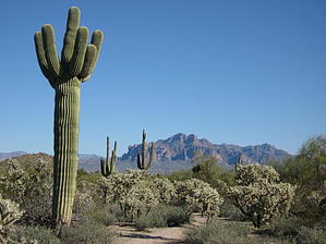
Something for everone by AZLOT69   History HistoryIn January 1892, there was a stagecoach holdup out of Globe. King Usery and Henry Blevins held up the Globe-to-Florence stagecoach (traveling the Howard and Reduction Toll Road) at Cane Spring in the Dripping Spring Mountains, just south of the Pinals. They netted two bars of silver bullion at $1500 each, a dozen gold breastpins at $20 each, and six gold eardrops valued at $90, as well as $200 cash. Usery was convicted and served some time in the Yuma Territorial Prison, but the jury wasn't sure about Bevins. The lawyers of the two men were paid in cattle for their retainer fee. As it turned out, both Usery and Blevins stole back their cattle from their lawyers, claiming that the fees were too high. This time both men were convicted and sent to Yuma. Hike Enter the Usery Mountain Regional Park for an adventure on the Blevins Trail. This loop trail is well suited for hiking, jogging, mountain biking, walking your dog, or horseback riding. Access from within the park can be had at either trailhead off Blevins Drive. Be sure to ask for a map when paying your entrance fee. You can avoid an entrance fee by using any trailhead off Meridian Road north of Brown and using one of the many connector trails to get to Blevins. The Usery Park has excellent facilities for a cross-section of people to enjoy. A covered playground for children, covered picnic tables, and bar-b-que grills encourage you to make a day of it.
Check out the Official Route and Triplogs. Leave No Trace and +Add a Triplog after your hike to support this local community. | |||||||||||||||||||||||||||||||||||||||||||||||||||||||||||||||||||||||||||||||||||||||||||||||||||||||||||||||||||||||||||||||||||||||||||||||||||||||||||||||||||||||||||||||||||||||||||||||||||||