Overview
FW Trailhead - 4.5 miles on the Dutchman Trail to Bull Pass junction. Follow Bull Pass Trail 0.6 miles to Bull Pass Saddle. Follow faint trail 0.6 miles to the top of Black Top Mesa. Return the same route.
Atop Black Top Mesa is some of the best overhead views of the western Superstitions. This is a pretty straightforward out and back hike. The trail starts at First Water Trailhead. Follow the Dutchman Trail for 4.5 miles to the Bull Pass junction. Turn left onto Bull Pass Trail. The trail crosses a creek bed immediately and is slightly overgrown. Without much ado, the trail heads up 467 feet to Bull Pass Saddle. On the saddle, you will see a "use" trail heading up to the right. This is the route you need to ascend Black Top Mesa. It's another 571 feet to the top.
From the Dutchman/Black Mesa junction to the top is about 1.2 miles. The ascent may seem steep due to fatigue from the previous 4 miles. It's not too bad. The average grade of the ascent is approximately 18 degrees. For reference, Camelback is steeper with an average grade of 23 degrees.
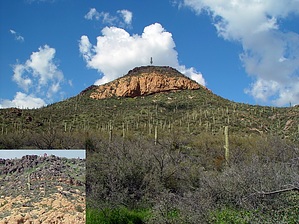
The Spanish Hieroglyphics are the main draw to the area. They're somewhere on the black rocks that line the southwest edge. I didn't see them. Then again I didn't look very thorough. I'd been excited to hike up the mesa all summer after looking at the 3D topos. The trail doesn't seem to get much mention anywhere. When it does get mentioned it's all about the hieroglyphics. My thoughts from the get-go were the views would be incredible in all directions. They were pretty darn good all around. You might not be as excited if you don't know the area. The top is like a big slanted wheat field. I didn't see any campsites for the record. If that's your thing I'm sure you could make do in a couple of places. I'd forget a campfire though! ( too much tall grass ) There isn't a high point with 360 views so you'll need to roam around. My photos include many of the views. Included is a head-on view of the popular Weavers Needle. Check 'em out!
The weather was very warm for late October in the low 90's. When it cools down I'm sure I'll be back. A great alternative on the return would be Boulder Canyon Trail. This would add a few miles. Probably worth the extra effort if it's cool outside!
WARNING! Hiking and outdoor related sports can be dangerous. Be responsible and prepare for the trip. Study the area you are entering and plan accordingly. Dress for the current and unexpected weather changes. Take plenty of water. Never go alone. Make an itinerary with your plan(s), route(s), destination(s) and expected return time. Give your itinerary to trusted family and/or friends.
Permit $$
None
Directions
Road
FR / Dirt Road / Gravel - Car Okay
To First Water Trailhead From Mesa follow Highway 60 East to Idaho Road. Turn North onto Idaho Road which is SR88 and follow North 2.2 miles. SR88 bends right just past Scenic St. and Idaho continues North. Be sure to go right and stay on SR88. Follow SR88 5.2 miles to the signed turnoff for First Water Trailhead, this is FR-78. Turn right on to FR-78 and follow 2.6 miles to the end.
This trailhead feature restrooms without running water. The large parking area fills up in season. When full utilize the Horse Lot 0.5 miles back.
From PHX (I-10 & AZ-51) 43.1 mi - about 59 mins From TUC (Jct 1-10 & Grant) 136 mi - about 2 hours 16 mins From FLG (Jct I-17 & I-40) 187 mi - about 3 hours 3 mins
 Route Editor

 Overview