 Route Editor

| Guide | ♦ | 85 Triplogs | 4 Topics |
details | drive | no permit | forecast | route |
stats |
photos | triplogs | topics | location |
| 1.3k | 85 | 4 |
Canyons are inherently risky. Flash floods occur without notice on sunny days. Technical skills & surrounding topography knowledge required yet does not eliminate risk.
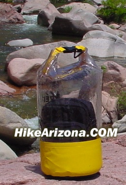
Gems in the heart of WCC by joebartels  Overview OverviewPerhaps a dozen 20~100 yard swims mixed in with a little rock hopping. On route, you pass through the White Box Narrows to "the" gem of West Clear Creek, the Hanging Gardens. Locals have called the garden Cache Hole for 70+ years according to cabemonroe. This canyon is best experienced when it's hot outside! Gear Being prepared will enhance your experience. The latest and greatest in amphibian footwear is probably the way to go. Personally, I wore Teva sandals like all other hikes. An inner tube makes travel much more enjoyable. A dry bag will keep your camera, wallet, and other sensitive gear dry. Trekking poles would be a burden so leave them behind.
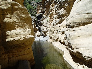
This moderate canyon jaunt starts at the end of FR142J. Albeit bumpy it is accessible via a non 4x4 high clearance vehicle. Bear in mind... in heavy rains, even a 4x4 may render you abandoned. Looking out, you have Buckhorn Mountain on the horizon. Slightly to the left is a cairn marking the route down. First, you transverse a layer of basalt that protects the edge of the canyon. The route is well cairned. Just watch your step as it is steep on loose ground. In 15-25 minutes you'll be near the creek in an inviting environment. Canyon When entering the creek, be sure it's clearly cairned or flagged in some manner, or you might forget where to exit on the return. Now in the canyon, head left downstream. You won't get far before you need to get your feet wet. The next pool is more or less a swim. The third encounter (as of this writing) leads you into the White Box. This is the elusive wall-to-wall coconino sculpted narrows of WCC. The name is a misnomer as Coconino is a light shade of orange. A cheap floaty tube is my preferred mode of transportation in this canyon. Take your time and remember to look up on your journey. Logs are wedged in the walls midway through the box. Exiting the White Box, you will encounter approximately (I did not count) ten swims on route to the Hanging Gardens. Most of the swims are shorter, and some are shallow. None feature the wall-to-wall narrows, but some have a wall on one side. All are unique and a pleasure to experience! After 1.5 miles of pool hopping you come to the Hanging Gardens immediately after Meadow Canyon enters the scene. It's fun to swim or tube under the overhang and check out the spring in back. Return The preferred return is a backtrack of the route. You can climb out of the canyon via the east ridge of Meadow Canyon. It's steep at the bottom and top with a very sparsely cairned route. Check out the Official Route and Triplogs. Leave No Trace and +Add a Triplog after your canyon trip to support this local community. | |||||||||||||||||||||||||||||||||||||||||||||||||||||||||||||||||||||||||||||||||||||||||||||||||


