Route Editor

| Guide | ♦ | 452 Triplogs | 4 Topics |
details | drive | no permit | forecast | 🔥 route |
stats |
photos | triplogs | topics | location |
| 1.2k | 452 | 4 |
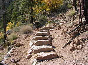
Heart Pumper by desertgirl  Note NoteThe lookout tower has been closed to the public since 2009. It is still a fabulous hike. See 2017 report. Overview What a trail - Short and strenuous ascending 2000ft in about 2-miles, Great views of the city of Flagstaff and surrounding Coconino plateau, a forest on the mend from a 1977 fire, and some exciting terrain described as "Corduroy cast in stone" and "Staircase of petrified lava" ( not sure about the correctness of "petrified"), make this a must-do.
Elden Lookout Trail #4 begins deceptively flat for the first ~mile as it winds its way through fragrant stands of juniper, pinyon pine, and ponderosa. You soon reach the sign for FatMan's Loop and Pipeline Trail. Upon reaching the base of the mountain, the trail begins to climb in earnest with several switchbacks. This steep & rocky trail has a lot of work into it - stone stairs, cribbing to support the trail as it hangs out over space, and a fair amount of stabilization to limit erosion. Sparse forest allows for great views to the north and east into East Flagstaff, Doney Park, Sunset Crater area, and the painted desert is on the horizon. The impressive rock formations resulting from the cooling & shrinking of lava attest to the volcanic origins of Mt. Elden. Clinging onto the rocky terrain with shallow topsoil are stands of Alligator Juniper, Ponderosa Pine, Gambel Oak, Mountain Mahogany & Cliff-Rose. The steep climb puts you on the ridge top at 2.8-miles from the trailhead. Bleached skeletons of pine, blackened trees, and thickets of young aspen greet you. This is the result of the Radio Fire of 1977 that devastated much of the top and eastern slope of Elden. The young aspen are a sign of the land in recovery. These thickets will become tall trees and provide nurturing shade for the pine forests to take hold, which will eventually thin out the aspen and return the slopes of Elden to mixed conifer forest. You will encounter a sign: 0.2-miles to the Lookout. Make this final ascent to the top through aspen thickets to great views all around - North: San Fransisco Peaks & city of Flagstaff, Southwest: Oak Creek Canyon & Mingus Mountain, South: heavily forested Mogollon Rim country and cinder cones to the east. There are several radio towers at the top as well as a lookout station atop Elden. Return the way you came - a lot more fun going down. Carry all the water you need. This is an early morning hike to avoid the heat and lightning from afternoon thunderstorms. You can take a detour through Fatman's loop on your return for added variety.
Coconino FS Details From its base, the southeastern slope of Mount Elden looks like corduroy cast in stone. This trail leads you up that staircase of petrified lava to the mountain's summit 2,300 feet above Flagstaff. The route starts as a gradual climb along the shorter and less steep Fatman's Loop but increases in gradient as the Lookout Trail strikes out on its own ascent to the mountain top. Along the way, you'll want to stop and catch your breath while you enjoy breathtaking views of the city and surrounding area as well as intimate views of the mountain's very visible geology. The lower reaches of the trail pass through a mixed pinyon-juniper woodland and ponderosa pine forest changing to mixed conifers as you climb. You may be surprised to encounter a couple of different kinds of cactus in this high, cold environment where they seem to do very well. Near the top of the climb you'll walk through an area devastated by a huge wildfire in 1977. Here, you'll see how much destruction can result when a simple campfire gets out of control. At the same time, you'll get a first hand look at how nature recovers from such a catastrophic event. Groves of aspen trees are springing up where pines once stood. They are the first step in a chain of events that will eventually result in the growth of another pine forest here. Before that happens, Flagstaff and its visitors will get to enjoy many years of fall colors visible from most of town. The Elden Lookout Trail connects to the Oldham Trail at the top of the mountain making a long loop hike possible if you park a car at Buffalo Park or arrange a pickup there.
Check out the Official Route and Triplogs. Leave No Trace and +Add a Triplog after your hike to support this local community. | |||||||||||||||||||||||||||||||||||||||||||||||||||||||||||||||||||||||||||||||||||||||||||||||||||||||||||||||||||||||||||||||||||||||||||||||||||||||||||||||||||||||||||||||||||||||||||||||||||||||||||||||||||