Note
Page statistics are for trail #44. The description below is from a place you can park.
Overview
There are lots of ways to access the Wilderness of Rocks area. This hike takes the most straightforward and most direct route. If all the parking at the smallish trailhead is taken, as it often is during summer, you can go down to Marshall Gulch Picnic Area (see Joe's description of the Aspen Loop) and access the Marshall Saddle trail junction that way.
remove free decal offer
Hike
Starting from Carter Canyon road, the trail climbs uphill for a short way and then contours around the mountain through a scenic spruce and fir forest. It passes by Mint Spring and then heads over to Marshall Saddle and a confusing trail junction. The Wilderness of Rocks trail takes off to the west, winding through very large granite boulders, a preview of what's to come. The trail eventually reaches the head of a stream course. It follows the small permanent stream down, jumping from one side to the other. Small aspens grow in the canyon. Soon after passing a junction with the Lemmon Rocks Lookout trail, the trail snakes across an outcrop of granite that marks the beginning of the Wilderness of Rocks. The granite formations get more and more spectacular as you go along. Hoodoos, balanced rocks, and water-carved canyons abound. The trail gets faint at times when it crosses stretches of bare rock, but it is well-cairned and easy to follow for the most part.
The trail climbs out of the basin and the rocks and into piney uplands on the far side. Very soon after that, the trail passes a small pocket meadow and climbs uphill briefly to meet a junction with the Mountain Lemmon trail. This is where I turned around. Save your energy on the hike in, as it is a mostly uphill climb all the way back to your car.
Coronado FS Details The name of this trail certainly does catch the attention of anyone scanning a trail map or thumbing through a guide book. The Wilderness of Rock Trail is extremely popular and with good reason. Picturesque rock formations and a diversity of settings that range from sub-alpine to high desert to riparian zone attract so many people that this area is somewhat overused by backpackers and day hikers. Trampling of the area is so heavy in some places that the trail has become difficult to follow and hikers have become lost. Be sure to follow the marked trail carefully. Watch for rock cairns (small stacks of rocks) to guide you through difficult areas.
As you move into this natural sculpture gallery and see the art works of wind and water from a number of different perspectives, you'll be amazed at the variety of shapes they can assume. Long distance views are good in this area too, including Mt. Lemmon, Sabino Basin and Pusch Ridge. Lemmon Creek, near the Marshall Saddle, is a popular destination on this trail. If you camp here, remember to practice sound wilderness and Leave No Trace ethics and camp at least 200 feet from the water.
This trail can be accessed from a number of different connecting trails. It is possible to plan a hike here that includes many of the major features of the Santa Catalinas. Some of the most popular access routes include the Marshall Gulch #3, Aspen #93, Romero #8 and the West Fork #24 trails.
Attractions:
Spectacular natural sculptures
Great long distance views
Access to other trails
Several loop possibilities
Arizona Trail segment
When hiking several trails on a single "hike", log it with a generic name that describes the hike. Then link the trails traveled, check out the example.
WARNING! Hiking and outdoor related sports can be dangerous. Be responsible and prepare for the trip. Study the area you are entering and plan accordingly. Dress for the current and unexpected weather changes. Take plenty of water. Never go alone. Make an itinerary with your plan(s), route(s), destination(s) and expected return time. Give your itinerary to trusted family and/or friends.
Four specific day-use areas require a Coronado Recreational Pass or a National Pass/America the Beautiful Pass.
1) Sabino Canyon - located on the Santa Catalina Ranger District (520)749-8700
2) Madera Canyon - located on the Nogales Ranger District (520)281-2296
3) Cave Creek - located on the Douglas Ranger District (520)364-3468
4) Mt. Lemmon at 11 day-use sites.
2025Catalina State Park
Per vehicle (1 person): $10.00
Per vehicle (2-4 people): $20.00
Individual/bicycle: $5.00
Coronado Forest MVUMs are rarely necessary to review unless mentioned in the description or directions Coronado Motor Vehicle Use Maps (MVUMs)
Directions
Road
Paved - Car Okay
To hike Take the Catalina Highway out of Tucson and into the Santa Catalinas. Turn left into the town of Summerhaven, then turn right onto Carter Canyon Road. The trailhead parking area is unmarked, no more than a widening in the road right before it turns into a private driveway. The actual trailhead is on the south side of the road, somewhat hidden right near the entrance to the private driveway.
 Route Editor

 Note
Note As you move into this natural sculpture gallery and see the art works of wind and water from a number of different perspectives, you'll be amazed at the variety of shapes they can assume. Long distance views are good in this area too, including Mt. Lemmon, Sabino Basin and Pusch Ridge. Lemmon Creek, near the Marshall Saddle, is a popular destination on this trail. If you camp here, remember to practice sound wilderness and Leave No Trace ethics and camp at least 200 feet from the water.
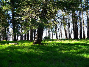


