 Route Editor

| Guide | ♦ | 89 Triplogs | 3 Topics |
details | drive | permit | forecast | route |
stats |
photos | triplogs | topics | location |
| 1.3k | 89 | 3 |
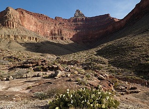
Inner Mystical by doug h  History HistoryThe Clear Creek Trail was built in 1934 and 1935 by the Civilian Conservation Corp (Company 818). It was originally built as a mule trail so visitors at Phantom Ranch would be able to gain access to a scenic side canyon. At the same time, Clear Creek was stocked with trout so that visitors could do a bit of fishing. All mule activity to Clear Creek died with World War II, a period when the park experienced extremely limited visitation. Today, this is the only trail traversing the Tonto Platform on the north side of the Colorado River. Because the slope is south-facing, the hike from Bright Angel Campground to Clear Creek is warmer than most trails in the fall and spring; it is nearly impassible during the summer months. Clear Creek experiences the highest visitation in March and April by hikers interested in seeing Cheyava Falls. The falls were first discovered in 1903 when a prospector saw what he thought might be a sheet of ice coating the cliffs up the northeast arm of Clear Creek drainage. The Kolb brothers, famous photographers who lived at Grand Canyon Village on the South Rim, caught wind of this and decided to investigate. They found what is, at around 800 feet, the highest waterfall at Grand Canyon. But the water only flows in relation to snowfall, after a wet winter; in drier years it does not flow at all (Cheyava is a Paiute word meaning "intermittent waters").
This trail offers something for the backpacker and the day hiker staying at the Phantom Ranch. Day Hikers will find that the first 2 miles have great vistas. While the backpacker will find that this trail leads to more to be explored. For backpackers there is no camping for the first 2 miles of the trail, this is the first major draw or the second pour off but then it is camping at large, this is also a good turnaround for day hikers. Hike This hike starts at the Phantom Ranch at the bottom of the Grand Canyon, with an elevation of approximately 2600 ft. The Clear Creek trailhead is about a 1/2 mile up the North Kaibab Trail in a small drainage. The sign for the trail is about 25 ft. off the main trail. The trail takes off to the right and starts to climb fast. About 3/4 of a mile from the trail junction is an overlook of the Phantom Ranch and a bench to take a rest, as you've only done half of the climb to the plateau. This bench was put in the thirties by the CCC, as was the trail. The next part of the trail has great views of the river gorge and bridges below. The trail contours along the Tonto Plateau to Zoroaster Canyon with views that are awesome. The trail goes north into Zoroaster Canyon climbing to 4100 ft., the highest point of the trail. The trail then works through a couple of saddles to overlook Clear Creek. The trail then drops down sharply over a hill that looks like reddish-brown cinders to the Clear Creek Campground. At the campground, there is a dehydrating toilet and Clear Creek, the only reliable water on the trail. The elevation at the campground is about 3600 ft. For the Backpackers a good day hike from the campground is Cheyava Falls, the highest falls in the canyon To get there go up the creek about a mile to the first creek from the East, the falls are about 3 miles up this creek on the right side. On the way up there are some Anistazi ruins near the confluence of the creeks and near the falls. Keeping into consideration that after a dry winter the falls will not be running. Getting into this area expect to get your feet wet and to fight the brush but it is well worth it.
Grand Canyon NPS Details Hike: From the junction with the North Kaibab Trail, the Clear Creek Trail climbs through a series of switchbacks to the southeast towards Phantom Overlook (a sharp switchback with a landing where there are a few stone benches; from this point there is a good view looking straight down at Phantom Ranch). After passing Phantom Overlook, the trail continues up to the base of the Tapeats and then traverses to the east for another mile to the Tonto Platform. While walking along the base of the Tapeats hikers are exposed to the Great Unconformity, a gap in the geologic record spanning more than 1 billion years. After a final ascent to the top of the Tapeats, the trail contours along the Tonto Platform, crossing Sumner Wash and two minor drainages. The trail turns to the north when it intersects with Clear Creek drainage below Demaray Point: When Clear Creek Canyon appears on the right, hikers are still only half way to their destination. From here, the trail crosses shallow Zoroaster Canyon and then continues over an unnamed drainage to the north. Finally, at the end of the Tonto traverse, the trail drops into a drainage by traversing a long slope of brilliantly orange-colored Hakatai Shale. The trail ends at a dry tributary creek bed: Looking up this drainage one can see Brahma Temple. From here there is no trail, so it is necessary to hike down the drainage for approximately 150 meters to its confluence with Clear Creek. Most backpackers camp at the many impacted sites just downstream from the confluence. A faint route continues downstream to the confluence with the east fork of Clear Creek. Hiking to the Colorado River via the creek requires scrambling and numerous creek crossings. It is approximately six miles one way. A quarter mile from the river there is a pour off that requires a fifteen foot down climb. This climb can be wet and icy, so use extreme caution, and don't attempt if you don't feel comfortable with free climbing. Allow a full day to complete this hike. Many hikers also day hike up Clear Creek to Cheyava Falls. This is a five mile hike one-way and follows the creek bed. Allow a full day to complete this hike. Cheyava Falls only flows in the spring after winters with high snow fall. Notes: Clear Creek is extremely popular in the spring and fall and permits may be difficult to obtain. Plan ahead! Many first-time backpackers to Clear Creek attempt to hike from the South Rim to the Clear Creek Use Area, however by the time they arrive at Bright Angel Campground they are exhausted. If Bright Angel is not on the itinerary listed on your permit, DO NOT EXPECT TO CAMP THERE! It is recommended that you obtain a permit with Bright Angel Campground as your first and last nights. The nine mile stretch from Phantom Ranch to Clear Creek is south facing and consequently is in the sun from sunrise to sunset. Expect neither shade nor water for the entire length of the trail. During spring, summer, and fall months it is best to hike this trail in the extremely early morning or in the evening. Water Sources: Phantom Ranch, Clear Creek, Colorado River, and seasonally at Sumner Wash (potholes). THERE IS NO RELIABLE WATER SOURCE BETWEEN PHANTOM RANCH AND CLEAR CREEK! Campsites The Clear Creek Use Area (AK9) is currently designated as "at-large" camping with the following exceptions: No camping in the Clear Creek drainage from its mouth at the Colorado River upstream to the first major side canyon entering from the east, and between the North Kaibab/Clear Creek Trail junction and Sumner Wash, a distance of two miles. Two large trailside cairns mark the first legal camping on the west end of the Clear Creek Use Area. There are several campsites along the Clear Creek Trail on the Tonto Plateau. At Clear Creek, there are four campsites along the creek. They are not designated, but are recognizable. Bring your own animal proof container to safeguard your food. A composting toilet is located between the trail terminus and the Clear Creek drainage. Human waste and toilet paper are the only items that can be placed in the toilet. BE AWARE THAT THIS AREA MAY BE SUSEPTIBLE TO FLASH FLOODING! Check out the Official Route and Triplogs. Leave No Trace and +Add a Triplog after your hike to support this local community. One-Way Notice This hike is listed as One-Way. When hiking several trails on a single "hike", log it with a generic name that describes the hike. Then link the trails traveled, check out the example. | |||||||||||||||||||||||||||||||||||||||||||||||||||||||||||||||||||||||||||||||||||||||||||||||||||||||||||||||||||||||||||||||||||||||||||||||||||||||||||||||||||||||||||||||||||||||||||||||||||||||||||||||||||||||


