Route Editor

| Guide | ♦ | 314 Triplogs | 50 Topics |
details | drive | permit | forecast | route |
stats |
photos | triplogs | topics | location |
| 2.9k | 314 | 50 |
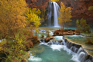
Land of the Blue-Green Waters by PhilipMueller  Help HelpIf you witness animal abuse, report it. Note Page mileage/gain is to the campground. If you go further, you will need to adjust your triplog data. This description the perspective of a 2009 hike. The summary below is to Beaver Falls 25mi RT & 2965 ft
32mi RT & 4500 ft Lodging & Gas The nearest lodging to Hualapai Hilltop, where the descent to Havasu Canyon begins, is about 70 miles away in Peach Springs. Another option would be the Grand Canyon Caverns & Inn, about 15 minutes east of Peach Springs on Route 66. While we are talking about lodging, let's also talk about gas. THERE IS NO GAS available in Peach Springs. We saw evidence that gas may have been available there; it is not now. Armed with false information on that point, we had to circle back to fill our tanks at the Grand Canyon Caverns & Inn. Your best bet for gas: tank up in Seligman. Eat at one of the cool restaurants on Route 66 while you're there, too! Westside Lilo's Cafe is excellent and has something for everyone. Hualapai Hilltop: Hell's Hilltop 5200 ft We thought it would be brilliant to camp on Hualapai Hilltop, right at the trailhead. In this way, we could break camp early and hit the trail! 1) Hualapai Hilltop is a parking lot. There is very little that is scenic about it. 2) There is not much redeeming about sleeping in a parking lot. 3) If you camp near the canyon walls, rocks and debris can fall on you. 4) The wind can be vicious, and it was while we were there. Gusts on the evening of Sat., 03 October ranged from 50 to 70 mph. There were four of us. Ed and Mitch hunkered down in the bed of Mitch's truck. Mike and Philip, who rode their motorcycles, made camp between an old camper, a pile of trash, and a torn-up couch occupied by a couple of stray dogs. Camping consisted of putting on every layer of clothing possible and pulling the sleeping bags tightly over our heads while the wind whipped cans and debris around us and dirt into our mouths as we gasped for air. To have set up a tent would have been nearly impossible, and had we been able, it would have assuredly turned into a kite to fly us off the cliff in the middle of the windy night. Besides the Havasupai parking lot security contingent, who slept in a trailer, we were the only morons attempting to sleep in the parking lot. It was a long evening. Now we laugh about it, and perhaps being "Canyon Crazies," we even enjoyed the humor of it all at the time; however, we recommend staying at one of the lodges and getting a good night of sleep! The Hike to Supai: I-10 Mileage from Hualapai Hilltop to Supai: about 7. The trail begins with a drop of about 1,000 feet on a series of switchbacks over the course of about a mile. Note on the switchbacks for your return trip: you don't want to do them in the full sun. Plan accordingly. After the switchbacks, the trail is a gentle grade to Supai, which sits at about 3500 ft. On the morning of Sun., 04 OCT 2009, after we fumbled around to break camp, we headed down the Havasu Canyon Trail in a stupor. The ferocious wind continued and would plague us the entire way to our destination, the campsite below the village of Supai, about 9.5 miles away. Visibility was poor, it was hard to breathe, and our eyes filled with dirt. Because it was so windy, the helicopters could not fly. This meant more foot and horse traffic was coming up the trail than usual because these were the only ways for those who flew down there to get back out. They joined the masses of hikers hiking out after their weekend of fun. It got old really fast to constantly jump off the trail to avoid being trampled by endless streams of pack horses that were charging, yes, charging, up the trail. We passed layers of Hermit Shale, Supai Sandstone, and Redwall Limestone, and that was all fine and good, but to Philip, the hike to Supai pretty much felt like the hiking equivalent of driving from Tucson to Phoenix on I-10. You attempt to entertain yourself looking at a few interesting things along the way, but you've been on much more scenic roads, and really you just want to get out of the horrendous traffic and get to where you are going. Bring on the blue-green waters! Supai to the Campground: Coca-colonization Mileage: After walking a flat, dirt road about a half a mile through town to the Havasu Cafe, you have another 2 plus miles to go downhill to the campground. You enter Supai along a wooded trail and walk parallel to Havasu Creek. This is your first sighting of the blue-green waters (color due to a large concentration of lime). Boy, it looks nice. Around the town, the canyon widens up and flattens out. You quickly come upon a little store that sells some snacks and other items. You walk along a dirt road, past some fields and houses. There is a small Mormon church. Stop in the Tourist Office to pick up your camping permits. After the tourist office, you'll come upon the Havasu Cafe. Mike and Philip stopped here. On how many prior hikes had they joked about a cafe waiting at the top of the mountain or in the depths of a canyon? Well, here, there was one. The prices were unbelievably low, considering the effort needed to get supplies. They even had veggie burgers. The fry bread was the main event, for sure, though. Yum. And to sit inside, sheltered from the wind, and sip a Coke was divine. Perhaps there is something to Coca-colonization after all. Note, there is a small grocery store across the street from the cafe. Both are open from approximately 0830 - 1730. From the cafe, it is about 2 plus miles downhill to the campground. You walk along a dirt road. About 1.2 miles down the road from the cafe, you see a waterfall to your left. If you look upriver just a bit, you see another waterfall coming out of a cliff covered with trees. Both of these are wide, relatively shortfalls - about 50ft. These are new waterfalls since the epic flood of 17 AUG 2008 that rearranged things down here. These new falls are quite lovely, and the running blue-green water is fantastic. Before the flood, there was a waterfall in this general area known as Navajo Falls. The flood changed the water flow, and now Navajo Falls is dry. The Havasupai are doing quite a bit of restoration work in this general area: roadwork, erosion control, etc.. About a mile from these two new falls' road viewpoint, you come upon the top of Havasu Falls. Havasu Falls is about 90 feet. The road takes you steeply to the left of Havasu Falls, and you get a pretty good view of it as you head down toward the campground, which you reach in about 1/2 a mile. You can access Havasu Falls via a trail that connects with the main road. Before the flood, Havasu Falls had two plumes; now it has one. Since the floods washed away the travertine reefs at the base of Havasu Falls, a new artificial reef has been put in place, and travertine is slowly starting to form again. The reef creates a large pool at the base of Havasu Falls. Campground The campground is well below the village at about 2800 ft, and Havasu Creek runs through it. It is easy to see why so many people were stranded in trees here when the flood-hit. It almost feels like a marsh. It is so wet. It is heavily wooded, and there are lots of nice camping spots. There is also a water pump. We did not find it necessary to treat the water from the pump. There are several bathrooms, but only one was actually open in the main camping area. Toilet paper was scarce. BRING PLENTY OF TOILET PAPER. After setting up camp, it's a great time to take the short walk back up to the pool below Havasu Falls for photos and a cold, cleansing, and refreshing swim! After we swam, we made some dinner and hit the sack. Mooney and Beaver Falls awaited us the next day. Mooney Falls & Beaver Falls: The Heart of the Matter Mileage: To Mooney, about 1 mile from the beginning of the campground. From there, about 2 miles to Beaver Falls. The campground straddles Havasu Creek for about a mile. Following the creek downstream to the campground's end, you come upon the top of Mooney Falls. Mooney Falls is about 200 ft. There is a steep downclimb to the bottom of Mooney Falls. There are chains and bolts for you to grip and some footholds here and there. You also go through two short, narrow tunnels. The lower half of the downclimb is wet. The whole thing is sort of like Picacho Peak, except it's wet. The downclimb to the pool at the bottom of Mooney won't be for everyone. Also, you won't want to take a big backpack with you on this downclimb; it will really get in the way and make it more difficult for you to balance yourself. The pool at the bottom of Mooney also has an artificial reef now. Staring at Mooney is a fantastic use of your time, but if you've come this far, you should consider going about two more miles to Beaver Falls. Follow the creek downstream. Sometimes there's a trail; sometimes, there isn't. Sometimes you'll walk on the left side of the creek, and sometimes you'll walk on the right side. Sometimes you'll walk in the creek. You'll see fantastic travertine reefs and pools and small waterfalls. You'll also enjoy a walk through a large field of Canyon Grape vines. Ultimately, about 1.5 miles from Mooney, you'll be looking for the only Palm Tree you are going to see around these parts. It will be on the creek's right side, and just behind it, there will be a canyon wall that shoots up from the water. Scaling this canyon wall is the traditional route to a cliff-side hike that takes you to the end of the Reservation and into the Grand Canyon National Park. There may be a rope there, but be very careful. Philip used the existing rope only to find at its anchor point that it was terribly frayed. The others in our group decided not to go up this way. Fortunately, they found another entry point to the cliff-side route further downstream. The fact of the matter is, you can only go so far in the water. The canyon slots up a bit, and Beaver Falls is a series of falls that will ultimately stop you in your tracks. You may also end up going down a fall and not being able to get back up. YOU NEED TO GET ABOVE THE FALLS TO THE RIGHT (the cliff-side hike). From the juncture of the Reservation and the Park, you can see Beaver Canyon. Also, you have an excellent view of the falls and "the blue hole," which is a large, phenomenal pool. We tried to find a route down to the blue hole. We got close, but we could not find a safe route to it. The Colorado River is about another four miles downstream from this point. Mitch had done this hike before the flood, and it was a tough hike, then. It is rumored to be even tougher now, after the flood. On the way back to the campground, near the upstream end of the field of Canyon Grape vines, we came upon a herd of Bighorn Sheep. Apparently, they are in that area a lot, and they were not very spooked by our presence. Seeing them made the Beaver Falls day hike, which was already fantastic, even better. Conclusion The hike to Beaver Falls is definitely best done over three days. Day 1 should be the hike to the campground. Day 2 should be the hike to Beaver Falls and the end of the Reservation. Day 3 should be the hike out. The heart of the trip to Havasu Canyon is found in the blue-green waters. Of course, the fact that there is a village at the bottom of a canyon in a remote region is neat, and it is something to see. The hike to the village might be interesting for some people, especially those with an eye for geology. Overall, though, it's all about the water. In that regard, as impressive as the initial falls are, it is really when you get downstream from Mooney that the connection with the beauty of this place is strongest. You get into the nuances of Havasu Creek, and you can explore to your heart's content. This is where the Bighorns hang out. They know a good thing. Oftentimes, people will compare the Havasu Canyon experience to Hawaii. Philip really did not see that comparison. The color of the blue-green waters reminded Philip more of the Caribbean than Hawaii. If there was any fall that might have looked like a waterfall in Hawaii, it might have been one of the new falls - the one that comes from the forest on the cliff's edge just outside of the village. Nevertheless, such comparisons do not do Hawaii justice. Nor do they do the depths of Havasu Canyon justice. What makes the depths of Havasu Canyon special is that the area is so different from its surroundings. A waterfall in a lush tropical forest in Hawaii is almost to be expected. Waterfalls, pools, and blue-green waters in the middle of a barren, dusty, dry landscape are not expected. Therein lies the special draw of Havasu Canyon. Therein lies the stark contrast that magnifies the unique beauty of the land of the blue-green waters, perhaps, beyond comparison. 2015 changes by azbackpackr As of September 2015: There are fairly new Phoenix composting toilets that do not smell at all. They are kept clean daily, with plenty of toilet paper and a bucket of the bulking material (sawdust) you are supposed to add. At the "palm tree" place where there used to be a rope going up, there are now ladders. There are a few more ATVs in use now. A police patrol goes through the campground. There is a ranger at Beaver Falls who checks your wristband or other evidence you have paid to get into the reservation. He also has the authority to charge river runners, who hike up from the Colorado River, $35(2015) each to swim at Beaver Falls since it is just a little bit within the reservation boundary. (The lower extreme of Havasu Creek is in Grand Canyon National Park.) As of the same date, the campground is fully recovered from past catastrophic floods. New picnic tables are found all along the creek between Mooney Falls and Beaver Falls, as well.
Check out the Official Route and Triplogs. Note This is a moderately difficult hike. Leave No Trace and +Add a Triplog after your hike to support this local community. | |||||||||||||||||||||||||||||||||||||||||||||||||||||||||||||||||||||||||||||||||||||||||||||||||||||||||||||||||||||||||||||||||||||||||||||||||||||||||||||||||||||||||||||||||