Username
Password
Stay on Help
Lookout Mountain Summit Trail #150, AZPrint Full | Basic
Directions
Description 193 Triplogs Laps0 Topics
RatedFavorite   Wish List Region
 
Mine
0
Friends
0
 Phoenix NW
Statistics
Difficulty 1.5    Route Finding
Distance Round Trip 0.98 miles
Trailhead Elevation 1,580 feet
Elevation Gain 436 feet
Accumulated Gain 498 feet
Avg Time Round Trip 0.75 hour
Interest Peak
Fastest splitjoe bartels
2011-10-217m 57s
Author Brems
 Descriptions 2
 Routes 0
 Photos 16
 Trips 11 map  (23 Miles)
 Age 32
 Location Phoenix, AZ
Photos
Rated Viewed All Mine Friends
7  2013-04-15 Bradshaws
3  2013-04-05 black toes
10  2013-03-25 Bradshaws
14  2013-03-18 Bradshaws
2  2013-03-09
 Lookout Mtn Circumference
 ZukerRach
3  2012-12-07 BobP
4  2012-05-09 Codersgirl
1  2012-04-01 trekkin gecko
10  2011-12-31
 Phoenix 7 Summit Challeng
 Tortoise Hiker
13  2011-12-31
 Phoenix 7 Summit Challeng
 coanbru
3  2011-02-25 Lovinthelight22
12  2010-12-24 tibber
Page 1,  2,  3
Large Profile
Forecast
Historical Weather
Radar
Backpack - Possible - Not Popular
Seasons - ALL
Official Route
 
Alternative Routes
 
Water
Nearby Hikes Area Water Sources
direct air miles away to trailhead
0.0  Lookout Mountain / Dead Wall
0.1  Lookout Mtn Circumference Trail #308
1.4  Shadow Mountain Summit from Acoma TH
1.4  Shadow Mountain 1779' Prominence
1.4  Shadow Mountain Big Loop #310
1.4  Shadow Mountain Mega Loop
[ View More! ]
Culture
 Cactuscat Pose
Space
Fauna
     Chuckwalla
     Great Horned Owl
     Great Purple Hairstreak
     Honey Bee
Space
Flora
     African Daisy
 Berlandier Wolfberry
     Blue Dicks
     Creosote Bush
     Fiddleneck
     Mexican Gold Poppy
   Mormon Tea - E. fasciculata
     Narrow-Leaved Popcorn Flower
     Scorpionweed
     Small-Flowered Eucrypta
Space

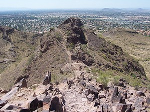
Lookout! Its a mountain..kinda
by Brems

Mobile Version
Hike: The trail (Trail #150) proceeds south from the parking lot up the north face of the mountain towards the saddle. There is available water here at the trailhead. Please note, that there are no restrooms on this trail.

There are several switch-backs, which decrease in amplitude as you approach the saddle. Many many years ago there were no route marking signs, however on the north face of the mountain, it is very obvious where the trail is. I hiked the mountain the other day, and couldn't help but notice that the city has put up a dozen or so sign posts marking this half of the trail. Once you reach the saddle, the trail becomes more interesting. Heading the east, the trail proceeds to follow the ridge, up to the named peak. There are a few parts here where the trail is not clearly defined. The basic idea is to keep going up. There is a bit of a rough spot at this point, where I would advise you not to fall down. My brother and I affectionately call this place the "butt (yet, we use a word that is synonymous with donkey) cracker". You'll know what I mean when you see it. After that bit of rough, the trail gathers itself back together and makes a quick shot toward the summit. A City of Phoenix brown painted steel post marks the actual summit.

This can be a quick hike for the average hiker, taking no more than 30 - 45 minutes from start to finish. Leashed dogs are allowed, but please pick up after your dog. There is nothing worse than stepping in a pile of the stuff while enjoying a quick hike. The trail is open from dawn until dusk.

- Mar 25 2007 Brems

Directions Preferred Months Jan Feb Mar Apr
Water / Source:None - However there is a faucet at the trailhead
Preferred Start7 AM Cell Phone SignalYes Sunrise5:18am Sunset7:41pm
Road / VehiclePaved - Car Okay
Fees / Permit
None

Directions
Print Version
To hike
The trailhead is located on 16th Street, south of Greenway Parkway. The short trail to the top climbs more than 500 feet in just under one mile. This trail also is accessible from Lookout Mountain Park, located at 18th Street and Sharon Drive. An access trail from the park joins the Circumference trail in .1 of a mile.

BREMS Writes: The main trailhead is on 16th Street roughly half a mile south of Greenway Parkway. Gates are open from dawn until dusk.
Login for Mapped Driving Directions
WARNING! Hiking and outdoor related sports can be dangerous. Be responsible and prepare for the trip. Study the area you are entering and plan accordingly. Dress for the current and unexpected weather changes. Take plenty of water. Never go alone. Make an itinerary with your plan(s), route(s), destination(s) and expected return time. Give your itinerary to trusted family and/or friends.

New Description!
Tres Rios Wetlands
Wings over Wastewater
- Outdoor Lover
About    Books    Grand Canyon    FAQ    Corrections    Go Mobile    Shop    © 2013 HAZ