 Route Editor

| Guide | ♦ | 3 Triplogs | 1 Topic |
details | drive | no permit | forecast | map |
stats |
photos | triplogs | topic | location |
| 29 | 3 | 1 |
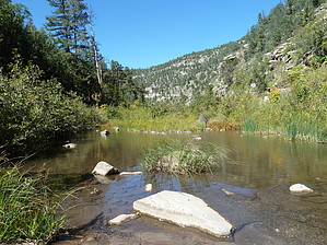
Rocking and Rolling to East Clear Creek by Dschur   This is the trail coming down from Clear Creek Pines Subdivision to Mack's Crossing. It was an old road that was abandoned in the 1940s. The trail is an old road and is very rocky and has some river damage across it. Just recently, the road is closed from Cedar Road. There is a sign that says Road Closed. You can park here, or just past the sign is a bigger pull-out. This is the trail coming down from Clear Creek Pines Subdivision to Mack's Crossing. It was an old road that was abandoned in the 1940s. The trail is an old road and is very rocky and has some river damage across it. Just recently, the road is closed from Cedar Road. There is a sign that says Road Closed. You can park here, or just past the sign is a bigger pull-out.The trail is straightforward to find since it is an old road. There are very nice views of the East Clear Creek Canyon and all the layers of Kaibab Limestone. You wander down through the limestone, and the cliffs are very fossiliferous. If you stop and look, you can see shells and even a rare Permian Trilobite. The limestone is Permian in age. As you wind down the road, you will cross many washouts on the road. (I even saw motorized tire tracks on the road even though they aren't supposed to be there) You go through the Permian Coconino Sandstone just before the creek. It is about 1.5 miles from the sign at the top till you get to the bottom. This trail could be pretty warm in the summer since it is South facing and not much shade. Unless you are going down to play in the creek, it would not be a good trail in the summertime. There are some pools at the bottom that you could use to play in.
Reference; Geologic Eras Gate Policy: If a gate is closed upon arrival, leave it closed after you go through. If it is open, leave it open. Leaving a closed gate open may put cattle in danger. Closing an open gate may cut them off from water. Please be respectful, leave gates as found. The exception is signage on the gate directing you otherwise. Check out the Triplogs. Leave No Trace and +Add a Triplog after your hike to support this local community. One-Way Notice This hike is listed as One-Way. When hiking several trails on a single "hike", log it with a generic name that describes the hike. Then link the trails traveled, check out the example. | ||||||||||||||||||||||||||||||||||||||||||||||||||||||||||||||||||||||||||||||||||||||||||


