2015
There are many opinions on the length of this trail, ranging from 50 to 54 miles. For this guide, it will be 52-miles. Because of its long-distance, this trail will take the average hiker from 3-5 days. Te-wa and I completed it in just under 2 (not recommended). There are now two sections of this trail that have received damage from wildfires, one segment between the Hatchery TH and Washington Park TH, which was damaged by the Dude Fire of 1990, and the February Fire of 2006, which burned a portion of the trail east of the Geronimo TH. However, these areas are decently marked, so finding your way along them will not be that difficult.
You can choose to start from either the Pine Trailhead or the 260 Trailhead. For this hike, we began at the 260 TH. From the start of the trail, you will head west toward the See Canyon TH, with constant climbing and descending. There is a big descent right before the See Canyon TH (approx. 6-miles from 260 TH) and Christopher Creek crossing, which will likely have water. Right after Christopher Creek, you will begin a hearty climb for the next few miles. As you wind your way around Promontory Butte, you will reach great views of the surrounding forest and then switchback down right before Horton Springs (approx. 13.5-miles from 260 TH), which is an excellent place to camp or refill your water.
After Horton Springs, you will again be on the rise, and around 3.5-miles, you will reach Tonto Creek and the Hatchery TH (approx. 17-miles from 260 TH), which has a few campsites nearby with easy access to the creek. From the Hatchery TH, you will be starting with, once again, another uphill. But now, as opposed to the Ponderosa pines that have dominated the first part of the trail, you will be walking on sandstone surrounded by chaparral and other knee-high grasses, and the charred remains of trees burned in 1990. However, with all of the downed wood, this has lead to great views. About 6.5-miles after leaving the Hatchery, you will pass Myrtle Trail and Ellison Creek. After crossing FR 144, you will continue through the burn area crossing over several smaller creeks. Then a few more ups and downs until out of nowhere, East Verde River appears along with the Washington Park TH (approx. 33-miles from the 260 TH) along with it's scattered campsites.
After crossing the road at the Washington Park TH, you will need to keep a close eye out for the trail markers, being sure not to turn onto the Col. Devin Trail. You will cross another road and walk past the Girl Scout cabin, working your way up the trail passing by another two creeks that had enough to filter. You will continue to work your way up the hills, although nothing as tiring as the eastern end of the trail, you will soon happen upon the area walloped by the February Fire. When I was there, the forest was just now starting to sprout up small grass and shrubs, but large blackened stumps and fallen trees dominated for the most part. After you reach the fire's outer edges, you will pass Bear Spring, and you will gradually, and then more rapidly descend toward the Geronimo TH and Webber Creek (approx 43 miles from the 260 TH). From there, the trail faintly makes its way up toward Milk Ranch Point, slowly but continuously climbing the next 4-miles, passing by both Pine and Red Rock Springs. At the time of my visit, Pine Spring was nothing more than a muddy spot on the ground, and Red Rock Spring had a constant trickle into its trough. However, after filtering a few quarts from the Red Rock Spring, the water tasted heavily of rust, so we dumped out our water and made the last 4-miles of the trip without any water. I would suggest not relying on those two springs, we were quite disappointed, and after coming 28-miles we were unable to drink until we reached our car. After around another mile, you will begin the long descent down Milk Ranch Point, lasting 2-miles until you intersect with the Donahue Trail. Afterward, you will reach level terrain, which after the last 50 miles, you will be able to cruise through, walking through a waymarked Ponderosa forest. Alas, 52-miles later, you will reach the Pine TH and the cabins that surround it.
When hiking several trails on a single "hike", log it with a generic name that describes the hike. Then link the trails traveled, check out the example.
WARNING! Hiking and outdoor related sports can be dangerous. Be responsible and prepare for the trip. Study the area you are entering and plan accordingly. Dress for the current and unexpected weather changes. Take plenty of water. Never go alone. Make an itinerary with your plan(s), route(s), destination(s) and expected return time. Give your itinerary to trusted family and/or friends.
Permit $$
None
Directions
Road
FR / Dirt Road / Gravel - Car Okay
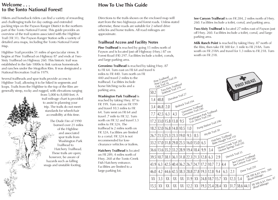
To hike 260 Trailhead - 27 miles east of Payson on Highway 260, on the west side
Pine Trailhead - 15 miles north of Payson on Highway 87 on FR 297
Trailheads West to East
Pine TH
Red Rock TH
Geronimo TH
Washington Park TH
Hatchery TH
See Canyon TH
260 TH
Connecting Trails
Babe Haught Trail #143
Col. Devin Trail #290
Derrick Trail #33
Donahue Trail #27
Drew Trail #291
Geronimo Trail #240
Horton Creek Trail #285
Myrtle Trail #30
Promontory Trail #278
Pump Station Trail #296
Red Rock Trail #294
See Canyon Trail #184
 Route Editor


 2025
2025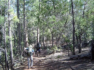


