username
X
password
register
for free!
help
 This is likely a great time to hike this trail!  Check out "Preferred" months below, keep in mind this is an estimate.
  

Wild Burro Trail - Lake Pleasant, AZ

Guide 13 Triplogs  0 Topics
  3.2 of 5  
Fav
Wish
1
details
drive
permit
forecast
route  
stats
photos
triplogs
topics
location
223 13 0
Statistics
tap row or icons for details
Difficulty 1 of 5
Route Finding 1 of 5
Distance Round Trip 4 miles
Trailhead Elevation 1,864 feet
Elevation Gain 150 feet
Accumulated Gain 150 feet
Avg Time Round Trip 2 hours
Kokopelli Seeds 4.75
 Backpack No
unreported if dogs are allowed
editedit > ops > dogs to adjust
feature photo
Photos Viewed All MineFollowing
Will recalculate on button tap!
8  2025-11-08 paulhubbard
14  2025-01-29 LosDosSloFolks
7  2024-02-09
Beardsley Trail - Lake Pleasant
LindaAnn
8  2024-02-09
Beardsley Trail - Lake Pleasant
trekkin_gecko
19  2024-01-29 LosDosSloFolks
13  2023-01-14
Cottonwood Trail - Lake Pleasant
DarthStiller
8  2022-12-03
Lake Pleasant Wander
topohiker
15  2021-07-24
Lake Pleasant Wander
topohiker
Page 1,  2,  3
Author
author avatar Guides 8
Routes 19
Photos 3,029
Trips 192 map ( 758 miles )
Age 67 Male Gender
Location Mesa, AZ
Associated Areas
list map done
Phoenix Region
Historical Weather
Trailhead Forecast
Radar Map
Expand Map
Preferred Jan, Dec, Feb, Mar → 7 AM
Sun  7:19am - 5:20pm
Official Route & 5 Rts
 
6 Alternative


Walk on the Wild Side
by paulhubbard

 Likely In-Season!
Expand MapOverview
If you're looking for that off-grid, out in the middle of nowhere, away from the hustle and bustle hike, this isn't it... But it's a nice little getaway, with a chance of seeing the namesake, some wild burros!
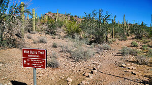

Hike
The trail starts at the intersection of South Park Road and Wild Tortoise, but there's no immediate parking there, so you can park at the wild burro area, which adds about a half mile to the trail length.
remove free decal offer
This trail is/was much prettier at higher water levels, when the trail would skirt the water's edge, but at low levels, the lake is not so invitingly far away. You meander between the lake and the roadways the whole way, terminating at the parking area for the Pipeline Canyon trail, where you can continue or head back.

2025-11-09 paulhubbard
  • 2018 PDF
    area related
    2018 PDF


Check out the Official Route and Triplogs.
Leave No Trace and +Add a Triplog after your hike to support this local community.
WARNING! Hiking and outdoor related sports can be dangerous. Be responsible and prepare for the trip. Study the area you are entering and plan accordingly. Dress for the current and unexpected weather changes. Take plenty of water. Never go alone. Make an itinerary with your plan(s), route(s), destination(s) and expected return time. Give your itinerary to trusted family and/or friends.

 Permit $$
Information is listed below


 Directions
or
 Road
Paved - Car Okay

To hike
From Phoenix, head north on I-17 and exit west on the Cartefree Highway/Wickenberg exit. Follow the highway to the Lake Pleasant Regional Park exit. There is a charge to enter the park.
page created by joebartels on Nov 08 2025 5:35 pm
helpcorrectionissue

end of page marker