Route Editor

| Guide | ♦ | 2 Triplogs | 0 Topics |
details | drive | permit | forecast | route |
stats |
photos | triplogs | topics | location |
| 37 | 2 | 0 |
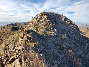
Optional, Non Mandatory and Non Persondatory! by Mike_W  Overview OverviewThis peak has an unusual name, maybe the most unusual name I've ever heard of for any peak I've ever hiked, and that's a lot. Non Persondatory Peak, apparently. The first 2.3 miles are on a good trail called the Orcut Trail. After that, the trail fades and disappears. There's an old concrete foundation and concrete dam in the canyon to the north. From the National Park boundary, it's about 1.3 miles to the summit. There are some use-trails along the way, either made by animals or people. There are two steep Class 3 sections along the way. At the summit, you'll have great views of Tucson and the towers on Trail's End Peak. History of the Peak Name Persondatory is apparently not a word - I checked. But, several years ago, a few SAHC hikers had summited the nearby Trail's End Peak. The hike leader pointed over to that peak to the North, which was known as Peak 4280, and said he was going to hike over there, but that it was "non-mandatory" for the other hikers. They could choose to go, or not. One of the other hiker's in the group joked that it should be called "non-persondatory", and the name stuck. See my trip report for the heated discussion about the history of how this peak got it's name.
From the Ringtail Trailhead, you'll see a sign for the Orcut Trail which heads north for the first 0.45 miles and then turns to the right after that and heads east for the next 0.45 miles. There's an archery range to the south of this second portion with some warning signs. Nobody wants to get hit with any arrows! Stay on the well-maintained trail for a total of 2.3 miles. You will see a forest service boundary fence and some signs with an opening letting hikers through. Keep following the trail/road up; eventually, you'll see a concrete foundation to the right. From here, faint trails lead higher up along the right side of a canyon. About 500 feet north of the foundation, you will see a concrete dam down in the canyon to your left. From here, continue north/northeast toward the low saddle above you. You don't need to go to this saddle. About 500 feet away from this saddle, you can turn right and work your way up to the ridgeline heading toward Non Persondatory Peak. It's pretty steep here and you will see some faint trails, either made by people or animals. I didn't see any cairns but you may find a few. Keep in mind there are many ways to go here. You'll need to stay near the main ridgeline, but when it gets too steep or rocky, there will always be an easier route around, sometimes to the left and sometimes to the right. At roughly 3.25 miles you'll see what looks like a wall in front of you. I found 2 ways to get past this wall. You'll see a spot in the middle where there's a narrow steep ramp going up to the left and a steep rocky area on the right which can be climbed. I climbed to the right and over a small cat claw vine. If I had my cutters, I would have cut this plant out of this area but it didn't seem to cause any problems for me. Once over the wall, the grade is very steep for a while and you'll need to weave and zig-zag. You'll need to hike south for about 250 feet or so to curve around some cliffs. Next, you'll want to climb up to the next level. You may see a use-trail or multiple use-trails in this area going up which you can follow. Once at the top of this next section, you'll be able to see the summit to the east and you'll also have a nice view of Trail's End Peak to the southeast. Continue toward the summit and stay right of the rocky ridge in front of you. You will approach the southwest side of the peak and you'll notice a steep channel leading up. This is your best way to get to the top. At the top, you will see a 5 or 6-foot metal pole at the high point. There's also a registry with a lot of old paper stuffed into the middle. Some of the older entries appeared to be sun-damaged. Look north and you will have some great views of Wasson Peak. Enjoy the views and you'll want to reverse the route on the way down. Keep in mind there are sometimes many ways to go and if you look at my route, you'll notice there are some differences between the up and down routes.
Check out the Official Route and Triplogs. Note This is a more difficult hike. It would be unwise to attempt this without prior experience hiking. Leave No Trace and +Add a Triplog after your hike to support this local community. | |||||||||||||||||||||||||||||||||||||||||||||||||||||||||||||||||||||||||||||||||||||||||