Route Editor

| Guide | ♦ | 13 Triplogs | 0 Topics |
details | drive | permit | forecast | map |
stats |
photos | triplogs | topics | location |
| 25 | 13 | 0 |
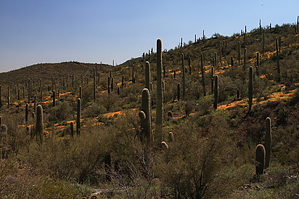
Hey...Pass the Coyote by fricknaley  This is another pleasant little leg out in the trail network of the eastern Tucson Mountain foothills of Saguaro National Park West. The trail is accessed from the Picture Rocks Wash, which I wrote up in a separate hike named Cactus Canyon. I would refer you to that hike for directions to the Picture Rocks wash via the Ringtail Trail. It is about 1 mile to the wash. At the wash, hang a right and travel along the wide and sandy wash for about 0.4 miles. This is another pleasant little leg out in the trail network of the eastern Tucson Mountain foothills of Saguaro National Park West. The trail is accessed from the Picture Rocks Wash, which I wrote up in a separate hike named Cactus Canyon. I would refer you to that hike for directions to the Picture Rocks wash via the Ringtail Trail. It is about 1 mile to the wash. At the wash, hang a right and travel along the wide and sandy wash for about 0.4 miles.Abruptly, a trail cuts out of the wash's left side, with a small marked sign announcing the departure. The sign reads Coyote Pass. Take this short trail as it climbs out and away from the main wash. In about 0.2 miles, you come to another signed split in the trail. To the right is Cactus Canyon. To the left is Coyote Pass.
After 0.8 miles, the trail deadends at an intersecting, wide wash signed as Gila Monster. I believe this leads to a mine, but I did not follow it today. Head back the way you came. At the Pass, you can climb up to a saddle in the ridgeline to your right. There is no trail, but it is a short and easy bushwack to the top. From here, there are nice views of the northern Tucson Mountains. You can also look down onto the old Yuma Mine, which is very close by. Kind of interesting. Afterward, just head back down the ridge to the trail and head back to the Picture Rocks Wash. You can go all the way back you came or continue down the wash to the signed Ironwood Forest trail that breaks out of the right side of the wash in a little over 0.3 miles. This route is also described in my Cactus Canyon write-up. This is the way I would recommend it. It adds a little distance and some very nice desert scenery to the hike.
Check out the Triplogs. Leave No Trace and +Add a Triplog after your hike to support this local community. | |||||||||||||||||||||||||||||||||||||||||||||||||||||||||||||||||||||||||||||||||||