username
X
password
register
for free!
help
  

Picture Rocks, AZ

Guide 8 Triplogs  0 Topics
  3 of 5 
Fav
Wish
1
details
drive
permit
forecast
route  
stats
photos
triplogs
topics
location
68 8 0
Statistics
tap icons for details
Difficulty 2.5 of 5
Route Finding 3 of 5
Distance Round Trip 3 miles
Trailhead Elevation 2,384 feet
Elevation Gain 497 feet
Accumulated Gain 568 feet
Avg Time Round Trip 2 hours
Kokopelli Seeds 5.84
 Interest Off-Trail Hiking & Peak
 Dogs not allowed
feature photo
Photos Viewed All MineFollowing
10  2022-10-27 Mike_W
4  2021-02-27
Ironwood Forest Trail - Saguaro NP West
chumley
10  2011-01-01 sirena
11  2010-12-22 IsAli
7  2009-03-14 fricknaley
6  2007-11-18 fricknaley
13  2007-09-16 fricknaley
7  2007-08-19 fricknaley
Author
author avatar Guides 93
Routes 396
Photos 4,216
Trips 3,566 map ( 23,327 miles )
Age 47 Male Gender
Location Tucson, AZ
Associated Areas
list map done
Tucson Region
Historical Weather
Trailhead Forecast
Radar Map
Expand Map
Preferred Jan, Dec, Feb, Nov → 8 AM
Seasons   Autumn to Spring
Sun  5:19am - 7:26pm
Official Route
 
2 Alternative
 
 Water


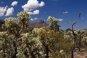
Picture This....
by fricknaley

Picture Rocks is an exciting little off-trail peak to bag when you don't have a lot of time. Picture Rocks is the distinctive peak guarding the eastern border of the north Tucson Mountain foothills. It is also the prominent peak just south of Contzen Pass.


Take off from the ubiquitous Ringtail trailhead as I described previously in my Cactus Canyon write-up. Follow this pleasant trail (as always) to its terminus at the Picture Rocks Wash. At the wash, turn left. All along the way, you are skirting around the base of Picture Rocks. Its western face is very steep, and while you could easily scramble over to its base from anywhere along this trail, it would be too steep to climb. The purpose of going all the way to the wash is to go around to the southern margin, which is still very steep, but from here, you can plot your route up. A small, broad saddle along the southeastern face serves as a break in the buttress that runs along the southern flank. This is where I recommend you aim.

I took the wash for just a short distance to plot my route. You can break out of the wash anywhere you please and start scrambling to the base. There is a small patch of prominent grey gravel about halfway up the southeast face. I aimed for this. The climb is VERY steep. Any steeper and you would not be able to stand. So be prepared to fall and skid and all that. From the grey gravel, patch look up and to your left. There is really only one way you can get up. There is a narrow chute to climb, and then you are pretty much there. There is a large chokestone in this chute. Please be wise and climb around (NOT ON) the stone to avoid any possible chance of dislodgement. This is the trickiest part of the climb. It is very exposed and requires a bit of tricky maneuvering. Once beyond this chute (with the palo verde tree stabbing you in the face as you pull yourself up), you are home free.


From the saddle, head left and up. There is a false summit. Beyond is the bi-domed summit of Picture Rocks with beautiful views of the Tucson Mountains and Contzen Pass below. Head down the way you came. Be careful at the chute, and again, please don't climb down with your weight on that chokestone. Cross country scramble back to the wash once you have descended the peak.

Check out the Official Route and Triplogs.

Leave No Trace and +Add a Triplog after your hike to support this local community.

2007-04-30 fricknaley
  • Rincon HAZ Map
    area related
    Rincon HAZ Map
  • Rincon Mountain Distric East
    area related
    Rincon Mountain Distric East
  • Tucson Mountain District West
    area related
    Tucson Mountain District West
  • SNP Cactus Forest Map
    area related
    SNP Cactus Forest Map
  • nps related
  • sub-region related
WARNING! Hiking and outdoor related sports can be dangerous. Be responsible and prepare for the trip. Study the area you are entering and plan accordingly. Dress for the current and unexpected weather changes. Take plenty of water. Never go alone. Make an itinerary with your plan(s), route(s), destination(s) and expected return time. Give your itinerary to trusted family and/or friends.

 Permit $$
None

Saguaro National Park
2022 $25 vehicle • $20 motorcycle • $15 individual on foot or bicycle
Receipt is valid for 7 days
$45 Annual Park Pass View All

No fee required from Miller Creek Trailhead off Mescal Rd.


 Directions
or
or
 Road
Paved - Car Okay

To hike
From Tucson
Take exit 246 off I-10 and go west on Cortaro until it ends at a T. Turn right here onto Ina for a short distance, then Left onto Wade. Wade quickly becomes Picture Rocks Road and crosses through the Tucson Mountains. You'll see a couple of signs announcing Saguaro National Park. As you come down the west side of the mountains the road swings hard to the right and there is a paved pull-out area to the right. Park here. The trails take off just across the street.
 90+° 8am - 6pm kills
helpcorrectionissue

end of page marker