Tallulah Gorge State Park Trails, GA • Hike


Tallulah Gorge State Park Trails, GA

Guide 2 Triplogs Mine 0 0 Topics
 
4 of 5 
Fav
Wish
0
details
drive
permit
forecast
map
stats
photos
triplogs
topics
location
21 2 0
Statistics
tap icons for details
Difficulty 3.5 of 5
Route Finding 1 of 5
Distance One Way 12 miles
Trailhead Elevation 1,673 feet
Elevation Gain 800 feet
Kokopelli Seeds 14.67
 Interest Off-Trail Hiking, Historic, Perennial Waterfall & Perennial Creek
 Backpack Yes
feature photo
Photos Viewed All MineFollowing
12  2012-06-17 satillayakker
9  2011-06-05 Kel1969
Author
author avatar Guides 7
Routes 0
Photos 99
Trips 2 map ( 3 miles )
Age 45 Male Gender
Location Satilla River Basin, GA
Associated Areas
list map done
Highlands Region
Historical Weather
Trailhead Forecast
Expand Map
Preferred Oct, Apr, May, Nov → Early
Seasons   Early Spring to Early Winter
Sun  6:50am - 6:38pm
Route
 
0 Alternative
 
 Water
Nearby Area Water
[ View More! ]
no photo labels yet
+Add > Photos to this Guide
then label as applicable
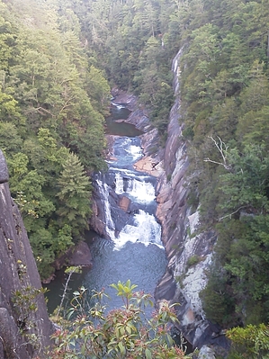
Georgia's "Grand Canyon"
by satillayakker

  
While not nearly as vast as the Grand Canyon, Tallulah Gorge is most definitely a sight to behold. Although Georgia has another canyon known as the "Little Grand Canyon", Tallulah Gorge is much more worthy of the title.
Most of the parks trails are out and back, with options to loop to other trails or to continue on longer and more difficult trails with a new name. (Basically one trail stops, and another picks up where it left off. Usually this marks a much more difficult trail.) Of the several trails in the park and the gorge, most are easily accessed and are easy to moderate, such as the Short Line Trail and North and South Rim. There are however a few that are strenuous, such as Hurricane Falls and Inspiration Point. Even some with much more risk, reserved for the more adventurous than what usually visits the park.

Most of the trails (Accessible through the State Park)start very near the gorge and continue along the rim. North and south rim trails offer breathtaking views and are not too populated. Especially the Hurricane Falls Trail which descends to the bottom of the gorge, offering beatiful waterfalls and a look up to Inspiration Point over 1000 feet up. There is also Rim to Rim hiking via Hurricane Falls. Access to the canyon floor is granted via permit, but if you go down, it is a long way back up. Most of the trail down is stairway because their just is no way to access the floor any other way. The cliffs and gorge walls are completely carved of solid rock.

As the trails range from difficulty, they also differ in compostion. Some trails are dirt with ALOT of exposed roots and smooth rock to all rock. You will find trails near the visitor center very improved and smooth, even with mulch and the further you go, the less improvements. There are virtually no improvements on some trails, making for a very exciting hike. Off trail hiking is not forbidden, but you have to be careful. THe Georgia Mountains are full of gorges and cliffs that take you by surprise, and Tallulah Gorge is NO EXCEPTION!

The park also offers trails with back country hiking and camping.

Tallulah Gorge is most definitely a place to visit if you love to hike, climb (permits can be obtained), bike or just get out there for a nice "walk: or a downright challenge!

Check out the Triplogs.

Leave No Trace and +Add a Triplog after your hike to support this local community.

2012-08-06 satillayakker

    One-Way Notice
    This hike is listed as One-Way.

    When hiking several trails on a single "hike", log it with a generic name that describes the hike. Then link the trails traveled, check out the example.
    WARNING! Hiking and outdoor related sports can be dangerous. Be responsible and prepare for the trip. Study the area you are entering and plan accordingly. Dress for the current and unexpected weather changes. Take plenty of water. Never go alone. Make an itinerary with your plan(s), route(s), destination(s) and expected return time. Give your itinerary to trusted family and/or friends.

     Permit $$
    Georgia State Parks: $5 daily, $50 annual - more information

    Chattahoochie Forest
    Chattahoochee-Oconee Passes & Permits


     Directions
    or
    or
     Road
    Paved - Car Okay

    To hike
    From Toccoa, GA, take highway US441 north to Tallulah Falls, GA. Once in Tallulah Falls, follow the signs for Tallulah Gorge State Park. Turn right after crossing Tallulah River and follow signs to Tallulah Gorge State Park.

    From Clayton, GA, take highway US441 south. You will cross over the Tallulah River a couple times as it switches back. Follow signs For Tallulah Gorge State Park campground or day use area. Campground will be located by left turn onto Jane Hurt Yarn Rd. Day use are is directly adjacent to US441.
    page created by HAZ_Hikebot on Aug 06 2012 8:59 am
    helpcorrectionissue

    end of page marker