The hike starts at the First Water Trailhead and follows the Second Water Trail #236 for about 1.5 miles through a couple of washes until you enter Garden Valley. Here you should find a sign indicating that Black Mesa Trail #241 turns to the right.
The Hiker's Guide to the Superstition Mountains says that it is a short hike down Black Mesa Trail to the Boulder Canyon. I guess that all depends on your definition of short. But I found it to be around 3.5 miles. Black Mesa Trail heads up across Black Mesa that from a distance appears to be a pile of black lava rocks around 2 miles down the path. Along this part of the trail, you can see Four Peaks in the distance on a clear day as well as a few teasing glimpses of Weaver's Needle.
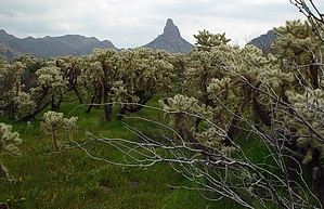
From the top of Black Mesa, you'll encounter a forest of Jumping Cholla Cactus that live up to their name in a slight breeze. I had one brush up against my walking stick and it took a little work to remove all the spines.
Working your way down from Black Mesa the trail will descend almost into Boulder Canyon crossing West Boulder. Here things get a little tricky. There is the main trail, which is indistinguishable from the horse and foot trails worn down by campers. If you are on the main trail, you should run into another sign indicating the junction of Black Mesa Trail with Dutchman Trail #104. But if you are on one of the alternative paths, you may see a large circle of rocks and continue walking past it. If you do miss the sign, you should bump into a second one marking the junction of Boulder Canyon and Dutchman's. Should you do that, backtrack away from Weaver's Needle to the circle of rocks and turn left on the footpath. You should then find the main sign about 200 yards away.
In Boulder Canyon, you have a very good view of Weaver's Needle. From here it looks a lot larger than from Fremont Saddle on the more traveled Peralta Trail on the other side. Other sites in the canyon include Battleship Mountain, Geronimo Head, and Malapais Mountain.
From this point, you will have about 4.5 miles to follow Dutchman Trail #104 back to the First Water Trailhead. If you started the hike in mid-morning, the cliffs will block some of the afternoon sun and will give you a break from the heat.
The aforementioned Hiker's Guide to the Superstition Mountains also mentions an alternative return path that is about 2.5 miles longer that follows Boulder Canyon Trail #103 back and connects with the Second Water Trail.
It never ceases to amaze me the number of people that go off on long trails with insufficient water. It was around 95 degrees in mid-October with a full sun overhead. On this mile hike, I consumed close to 3 liters of water. I encountered two different groups of hikers at both ends of the trail that had little more than a 25-ounce bottle with them for their hike. Due to the length of this hike, unavailable water, and a remote chance of missing the return marker, it can not be stressed enough to carry enough water on this hike. The park ranger told me that in the summer months, he would not attempt it with less than one gallon per person. This is a good all-day hike for the spring or fall months but I guess would be quite arduous in the 100+ days of summer. Except for the myriad of conflicting trails in Boulder Canyon, the trail is well signed and maintained. While there are no steep ascents like those found on the far side of Peralta, the larger rocks in the canyon washes require hiking boots with strong ankle support. Cell phone coverage is non-existent except for the trailhead parking area.
WARNING! Hiking and outdoor related sports can be dangerous. Be responsible and prepare for the trip. Study the area you are entering and plan accordingly. Dress for the current and unexpected weather changes. Take plenty of water. Never go alone. Make an itinerary with your plan(s), route(s), destination(s) and expected return time. Give your itinerary to trusted family and/or friends.
Permit $$
None
Directions
Road
FR / Dirt Road / Gravel - Car Okay
To First Water Trailhead From Mesa follow Highway 60 East to Idaho Road. Turn North onto Idaho Road which is SR88 and follow North 2.2 miles. SR88 bends right just past Scenic St. and Idaho continues North. Be sure to go right and stay on SR88. Follow SR88 5.2 miles to the signed turnoff for First Water Trailhead, this is FR-78. Turn right on to FR-78 and follow 2.6 miles to the end.
This trailhead feature restrooms without running water. The large parking area fills up in season. When full utilize the Horse Lot 0.5 miles back.
From PHX (I-10 & AZ-51) 43.1 mi - about 59 mins From TUC (Jct 1-10 & Grant) 136 mi - about 2 hours 16 mins From FLG (Jct I-17 & I-40) 187 mi - about 3 hours 3 mins
 Route Editor

 The hike starts at the First Water Trailhead and follows the Second Water Trail #236 for about 1.5 miles through a couple of washes until you enter Garden Valley. Here you should find a sign indicating that Black Mesa Trail #241 turns to the right.