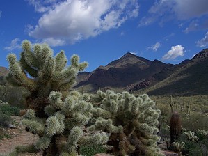
I am biased about how to approach Bell Pass since I live on the Scottsdale side of the McDowell mountain range; however, there are two ends to Bell Pass Trail. A day hike's goal from either end would be the Pass itself with its terrific views of Four Peaks, Superstitions, and the Phoenix Mountains. This description's mileage is to the Pass and back from the City trails starting from the Bell/104th St parking lot.
Take Levee Trail one mile then left on Paradise Trail then right (east) on Gateway Trail for 0.2 miles to the start of Bell Pass Trail. The remaining two miles to the Pass holds 1200 feet of elevation change, and now you know why you earn your view. Thompson Peak to the right and McDowell Peak to the left envelop you as your heart rate climbs. Those antennae on Thompson Peak all of the sudden don't seem so far away anymore. The trail towards the top of the Pass is slippery, small gravel, and some people prefer to have a hiking stick. Every craggy step is forgotten once you arrive at Bell Pass and stop to take in the peaks in the distance to the east and west.
For completeness sake, Bell Pass Trail does continue 1.3 miles descending east and then around a corner north to its other end. This is the Fountain Hills side of Bell Pass Trail connecting to the Prospector trail at 0.4 miles from the Pass and to the Windmill Trail at 1.3 miles from the Pass. It is an incredible maze of City trails linked with the McDowell Mountain Regional Park trails. Also, the other end of Bell Pass Trail becomes Windgate Pass Trail which connects with Gateway Loop creating several potential super loops in the area.
WARNING! Hiking and outdoor related sports can be dangerous. Be responsible and prepare for the trip. Study the area you are entering and plan accordingly. Dress for the current and unexpected weather changes. Take plenty of water. Never go alone. Make an itinerary with your plan(s), route(s), destination(s) and expected return time. Give your itinerary to trusted family and/or friends.
Permit $$
None
Directions
Road
Paved - Car Okay
To hike From the Loop 101
Take Bell Road exit (either FLW Blvd or Pima/Princess depending on your direction). After the intersection of Bell Rd with Thompson Peak Parkway continue east on Bell, and the gravel lot is on the left at 104th Street.
 Route Editor

 I am biased about how to approach Bell Pass since I live on the Scottsdale side of the McDowell mountain range; however, there are two ends to Bell Pass Trail. A day hike's goal from either end would be the Pass itself with its terrific views of Four Peaks, Superstitions, and the Phoenix Mountains. This description's mileage is to the Pass and back from the City trails starting from the Bell/104th St parking lot.