Conjunction junction, what's your function by Crzy4AZ
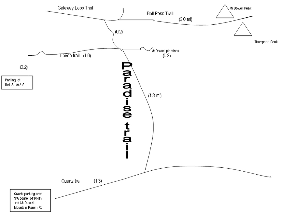
Chances are you won't hike (or bike) the Paradise Trail in isolation, and defining the start of the trail depends on your perspective. The trail follows the edge of developed land for 1.5 miles linking several City of Scottsdale trails around the McDowell mountain range (see map).
This description begins at the parking lot at Bell Road and 104th Street where you go 0.2 miles before signs for the Levee trail appear. Take the raised Levee trail for one mile to the intersection with Paradise.
Here you have three choices:
(1) To Bell Pass - go left 0.2 miles on Paradise trail to Gateway Loop then go right to meet up with Bell Pass trail in 0.2 miles. It's two miles of switchbacks from here to the great views at Bell Pass; (2) To McDowell pit mines - go right a few feet and then head up the hill; (3) To Quartz trail - go right 1.3 miles and follow the signs.
This description trailhead GPS coordinates are from the start of the Levee trail by the parking area at Bell & 104th Street. I chose this location since you can't access Paradise trail without starting on some other trail first. Here are the GPS coordinates for the three choices:
You'll find the Paradise trail to be isolated in sections and a wash below housing developments in other parts. The terrain is rocky with gentle ups and downs, which lends itself well to mountain biking, walking, or trail running.
When hiking several trails on a single "hike", log it with a generic name that describes the hike. Then link the trails traveled, check out the example.
WARNING! Hiking and outdoor related sports can be dangerous. Be responsible and prepare for the trip. Study the area you are entering and plan accordingly. Dress for the current and unexpected weather changes. Take plenty of water. Never go alone. Make an itinerary with your plan(s), route(s), destination(s) and expected return time. Give your itinerary to trusted family and/or friends.
Permit $$
Information is listed below
Directions
Road
Paved - Car Okay
To hike Directions: From 101 - take Bell Road exit (either FLW Blvd or Pima/Princess depending on your direction). After the intersection of Bell Rd with Thompson Peak Parkway continue east, and the gravel lot is on the left at 104th Street.
If you visit the mines or go off the labeled trails, you'll need an AZ State Land Trust permit.
 Route Editor

 Chances are you won't hike (or bike) the Paradise Trail in isolation, and defining the start of the trail depends on your perspective. The trail follows the edge of developed land for 1.5 miles linking several City of Scottsdale trails around the McDowell mountain range (see map).


