Route Editor

| Guide | ♦ | 34 Triplogs | 0 Topics |
details | drive | permit | forecast | 🔥 route |
stats |
photos | triplogs | topics | location |
| 215 | 34 | 0 |
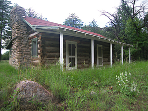
Chiricahua history hike by PrestonSands   The Silver Spur Meadow Trail is different from other trails at Chiricahua National Monument, in that it focuses on the area's history, rather than its unusual geologic formations. The Monument's trademark volcanic hoodoos are visible on the surrounding mountainsides, though. The Silver Spur Meadow Trail is different from other trails at Chiricahua National Monument, in that it focuses on the area's history, rather than its unusual geologic formations. The Monument's trademark volcanic hoodoos are visible on the surrounding mountainsides, though.Several historic structures can be seen along this beautiful valley near the Monument's entrance. There are many interpretive signs along this trail that give visitors an idea of what life was like for early settlers in this area.
A large sign next to the main road, about 100 feet west of the Monument's visitor center, marks the start of the Silver Spur Meadow Trail. However, the sign says Silver Spur Faraway Trail. The trail heads downhill, away from the road, in a northerly direction, and is well shaded in this area by junipers, oaks, and Arizona cypress trees. A long-needled apache pine or two can be seen, as well. You will soon make the first of three creek crossings along this hike. Rhyolite and Bonita Creeks are probably dry most of the time but beware of flash floods during monsoon season, which can make the trail impassable. About 0.2 miles from the visitor's center is a sign where the trail splits. The right branch goes to the Bonita Canyon campground. Stay left to continue to Faraway Ranch. A short distance later, the trail crosses Bonita Creek, then turns west and enters Silver Spur Meadow. Silver Spur Meadow was the location of a Civilian Conservation Corps camp during the 1930s. After building many of the Monument's roads and trails, this C.C.C. camp was closed in 1940. It later became the Silver Spur Guest Ranch. Two rock chimneys next to the trail here are all that remain of the C.C.C. camp and the guest ranch. At the west end of the meadow, the trail crosses over to the south side of the creek and follows it down canyon through the oak/juniper/cypress forest. The trail crosses a black wooden bridge and then a service road, before entering into a long meadow. The rustic Stafford Cabin, built-in 1880, is the first building you'll come across in the meadow. A little farther along is the Faraway Ranch. There are several historic structures here, including an old barn and the two-story Faraway Ranch house. The Silver Spur Meadow Trail reaches its western terminus a short distance beyond the Faraway Ranch, at a large parking and picnic area. Return the way you came, and enjoy! Check out the Official Route and Triplogs. Leave No Trace and +Add a Triplog after your hike to support this local community. | |||||||||||||||||||||||||||||||||||||||||||||||||||||||||||||||||||||||||||||||||||||||||||||||||||||||||||||||||||||||||||||||||||||||||||||||||||||||||||||||||||||||||||||||||||||||||||||||||||||||||||||