Route Editor

| Guide | ♦ | 83 Triplogs | 1 Topic |
details | drive | no permit | forecast | route |
stats |
photos | triplogs | topic | location |
| 399 | 83 | 1 |
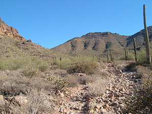
Suddenly no trail! by OhOh7  Note: Some may refer to this as "Fish Rock Loop". Note: Some may refer to this as "Fish Rock Loop".Another adventure into the Goldfield Mountains. Lots of old jeep roads and faint trails throughout the Goldfields. Although the trailheads are labeled most of the trails are not. The one we took today is called "Peak 3004 Loop". This route is about 5.5 miles RT but almost 2 miles of it is bushwhacking. There are a few cairns but many stretches without. I must give a WARNING about this route. If you do not have a sense of basic directions and a little bit of landmark knowledge you could run into some trouble. Also again I refer to the book Goldfield Mountain Hikes by Ted Tenny. This hike starts at the Meridian Trailhead (directions and coordinates below). There are two trailheads. One of them goes NW to join the Pass Mountain Trail that you can take either clockwise or counterclockwise for about an 8-mile circle. The other is called the Bulldog Saddle Trail and goes north and then NE up to the visible saddle. This is the right one for Peak 3004 Loop. The trail starts fairly smooth as it follows an old road. Then watch for the trail to narrow down and go NE toward the saddle. The trail is quite defined but very rocky and does climb almost 700 feet to Bulldog Saddle. Once you reach the saddle the views are astounding of the Salt River Valley. The reason this trail is called Bulldog Saddle trail is that most hikers turn around here to retrace back to the trailhead that would make a 3 mile RT.
After you pass Peak 3004 you have a choice of taking the high road or the low road. This means going the high side NW to get to the Pass mountain saddle or going more north down to the major wash, then SW up the wash to the Pass Mountain Saddle. We selected the high road and I found it to be somewhat difficult in places crossing a few washes and one particularly steep one. However, we made it to what looked like a cave in the base of Peak 3004. Close up it looks more like someone tried to mine there as it only goes back in about 20 feet and looks very man-made. When you reach the Pass Mountain saddle (there is a defined trail from that cave-like place) you begin to switchback down back to the trailhead about 2.1 miles away. The hike is classified as being fairly easy but considering the climb to the saddles, the bushwhacking, and crossing some washes on the high side it proved to be rather taxing but very enjoyable. Great views and lots of fun in wild country so close to Apache Junction. If you go on this loop be certain you know the landmarks and general directions to get back to the Pass Mountain trail. I have tried to label a few photos. Check out the Official Route and Triplogs. Leave No Trace and +Add a Triplog after your hike to support this local community. | |||||||||||||||||||||||||||||||||||||||||||||||||||||||||||||||||||||||||||||||||||||||||||||||||||||||||||||||||||||||||||||||||||||||||||||||||||||||||||||||||||||||||||||||||||||||||||||