Overview
This trail goes north from the Meridian Trailhead to Bulldog Saddle.
Hike
This unmarked but easy-to-follow trail is the first segment of the Peak 3004 Loop Hike. This portion of the hike is not the hardest hike in the world, but it is not an easy hike either.
Instead of doing the Peak 3004 Loop, novice hikers may wish to turn around and go back to the trailhead once reaching Bulldog Saddle. Once reaching Bulldog Saddle, more adventurous hikers might choose to go east up to Peak 3125. From there one could go back down to Bulldog Saddle; head south on the Ironwood Ridgeline 3108 Loop; or head north to Peak 3163, aka Hippy Hill and Bulldog Ridge.
When hiking several trails on a single "hike", log it with a generic name that describes the hike. Then link the trails traveled, check out the example.
WARNING! Hiking and outdoor related sports can be dangerous. Be responsible and prepare for the trip. Study the area you are entering and plan accordingly. Dress for the current and unexpected weather changes. Take plenty of water. Never go alone. Make an itinerary with your plan(s), route(s), destination(s) and expected return time. Give your itinerary to trusted family and/or friends.
Permit $$
None
Directions
Road
Paved - Car Okay
To Meridian Trailhead Meridian Trailhead is located at the north terminus of Meridian Road between Mesa and Apache Junction.
US60 to Signal Butte. Take Signal Butte north to University. East (right) onto University to Meridian. North (left) onto Meridian to the terminus. There is a small TH.
or
Exit 202 Loop at Brown Road and travel east on Brown Road for about 3.5 miles. From Brown Road (Lost Dutchman Rd), travel North on Meridian for two miles to the trailhead parking area at the end of the road.
From PHX (I-10 & AZ-51) 34.1mi - 44 mins From TUC (Jct 1-10 & Grant) 119mi - 2hr 11mins From FLG (Jct I-17 & I-40) 176mi - 2hr 56mins
 Route Editor

 Overview
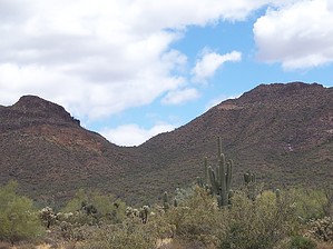


