Route Editor

| Guide | ♦ | 25 Triplogs | 0 Topics |
details | drive | no permit | forecast | 🔥 route |
stats |
photos | triplogs | topics | location |
| 327 | 25 | 0 |
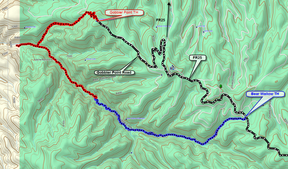
The Bears Are Watching by Rays  The Bear Wallow Wilderness is a lush valley with a perennial stream running through it located just south of Hannagan Meadow. We camped close to the trailhead the first night and awoke to howling coyotes answered by wolves. It was absolutely haunting! The next morning we shouldered our packs and descended 700 feet to Bear Wallow Creek. Even though it was late October, the forest was incredibly green with huge spruce trees with hanging moss. Springs seeped from the canyon walls. The stream was crystal clear with an occasional Apache trout darting from sunlight to shadow. There were small meadows with abundant signs of elk. We continued another 2 miles to the junction of Schell Canyon where we camped for the night. T-shirts were followed by more layers as the temperature plunged into the 20s. The Bear Wallow Wilderness is a lush valley with a perennial stream running through it located just south of Hannagan Meadow. We camped close to the trailhead the first night and awoke to howling coyotes answered by wolves. It was absolutely haunting! The next morning we shouldered our packs and descended 700 feet to Bear Wallow Creek. Even though it was late October, the forest was incredibly green with huge spruce trees with hanging moss. Springs seeped from the canyon walls. The stream was crystal clear with an occasional Apache trout darting from sunlight to shadow. There were small meadows with abundant signs of elk. We continued another 2 miles to the junction of Schell Canyon where we camped for the night. T-shirts were followed by more layers as the temperature plunged into the 20s.The next day we day hiked another 3 miles into the canyon dropping another 1200 feet. We crossed the creek 12 times and at one point the trail climbed the canyon wall and became quite narrow. The scenery continued to amaze us. The highlight was a high canyon wall with ferns and hanging grasses that reminded us of the Fern Grotto in Hawaii! The bear bells came out when we saw the first bear skat. More followed along with large over-turned rocks. We didn't see the bears but I swear they were watching us.
Check out the Official Route and Triplogs. Leave No Trace and +Add a Triplog after your hike to support this local community. | |||||||||||||||||||||||||||||||||||||||||||||||||||||||||||||||||||||||||||||||||||||||||||||||||||||||||||||||||||||||||||||||||||||||||||||||||||||||||||||||||||||||||||||||||||||||||||||||||||||||||||||||||||||||||||||||||||