 Route Editor

| Guide | ♦ | 3 Triplogs | 0 Topics |
details | drive | permit | forecast | 🔥 route |
stats |
photos | triplogs | topics | location |
| 26 | 3 | 0 |
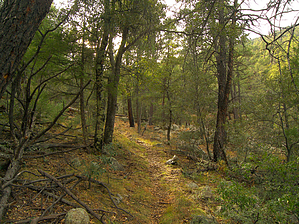
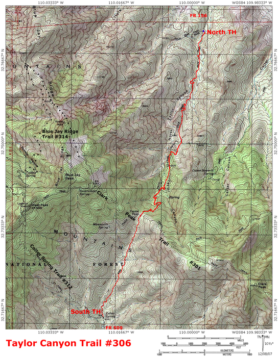
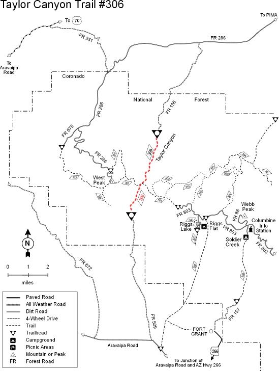
taylor-made isolation by PrestonSands   The Taylor Canyon Trail #306 is an up and over, high desert to tall pine route that runs through North Taylor Canyon, Taylor Pass, and finally down the south side of the Pinaleno Mountains, where it terminates at Colter Spring. This trail mainly serves as a connector route between the desert floor and the ridgeline route of the Clark Peak Trail #301. I have not hiked the southern 1.5 miles of this trail due to the 4x4 requirement for access to the south trailhead. A round trip hike on the northern/main section of this trail is 8 miles. Round trip distance for the entire trail is 11 miles. The Taylor Canyon Trail #306 is an up and over, high desert to tall pine route that runs through North Taylor Canyon, Taylor Pass, and finally down the south side of the Pinaleno Mountains, where it terminates at Colter Spring. This trail mainly serves as a connector route between the desert floor and the ridgeline route of the Clark Peak Trail #301. I have not hiked the southern 1.5 miles of this trail due to the 4x4 requirement for access to the south trailhead. A round trip hike on the northern/main section of this trail is 8 miles. Round trip distance for the entire trail is 11 miles.The Taylor Canyon Trail begins in oak woodlands where forest road #156 ends at a turnaround/camping area. This is the northern trailhead. The unsigned trail drops off the edge of the hillside and quickly descends to North Taylor Canyon's creek bed, which it then crosses. The trail's signpost (minus sign) is on the east bank of the creek. The first quarter-mile of the Taylor Canyon Trail is a little tricky to follow. Look for cairns and begin following its faint and somewhat overgrown route up the canyon, along the east bank. The trail crosses over to the west bank at 0.15 miles and slowly becomes more defined.
The Taylor Canyon Trail leaves the ridge top around the 6000-foot contour and begins to skirt the mountainside. The deep canyon begins to close in, and pines become more numerous. Following one more short stretch of the ridgeline, the trail starts to descend to North Taylor Canyon's floor below towering forested ridges. A collapsed mine tunnel and some small seasonal pools of water greet you in the well-shaded canyon bottom. The trail now crosses the creek and begins a prolonged ascent up the canyon's increasingly steep upper reaches via long switchbacks. The trail finally reaches Taylor Saddle at mile 4 and crosses the Clark Peak Trail at a pair of old trail signs. The Taylor Canyon Trail now heads south down the drainage of South Taylor Canyon. A few hundred yards down, some views open of the distant Galiuro and Rincon ranges over top of the Sulphur Springs Valley. This is where I turned around. According to the forest service, the Taylor Canyon Trail continues down the canyon along an old four-wheel-drive road and ends at Colter Spring. Here it meets the old Colter Spring Trail #312 on the canyon floor at the southern trailhead. This trailhead is accessible by forest road 509, a rough four-wheel-drive road from the Aravaipa Road.
Coronado FS Details You can go all the way up and over the Pinaleno Mountains on this trail, although most people use it as an access route to the range's high ridge from either the north or the south side. Both ends of the trail start in riparian areas that are quite similar. The southern trailhead is located at the north end of FR 509 near a small spring, named Colter Spring. This 4-wheel drive road is in bad condition north of the National Forest boundary. It is a good idea to park your vehicle at the boundary and start your trip there. Colter Spring usually has water. Both North and South Taylor Canyons have intermittent water and are usually dry during the hottest time of the year. From these canyons the trail climbs through oak and juniper stands to the saddle at the top of Taylor Pass. This is the lowest point on top of the Pinaleno Range but it still provides good views both to the north and south. At Taylor Pass, the trail crosses the Clark Peak Trail #301 which traverses from east to west. To the east, it leads to the summit of Clark Peak and on to the end of the Swift Trail (Highway 366). To the west, the Clark Peak Trail leads to the summit of West Peak. Check out the Official Route and Triplogs. Leave No Trace and +Add a Triplog after your hike to support this local community. One-Way Notice This hike is listed as One-Way. When hiking several trails on a single "hike", log it with a generic name that describes the hike. Then link the trails traveled, check out the example. | |||||||||||||||||||||||||||||||||||||||||||||||||||||||||||||||||||||||||||||||||||||||||||||||


