Route Editor

| Guide | ♦ | 30 Triplogs | 2 Topics |
details | drive | no permit | forecast | map |
stats |
photos | triplogs | topics | location |
| 410 | 30 | 2 |
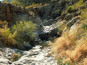
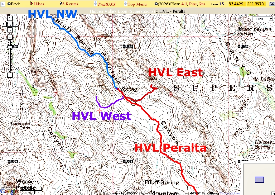
Bring your swimsuit by kanode  This was a two-day backpacking trip into Hidden Valley as described by Jack Carlson as Trip 14 in Hiker's Guide to the Superstition Wilderness. This was a two-day backpacking trip into Hidden Valley as described by Jack Carlson as Trip 14 in Hiker's Guide to the Superstition Wilderness.The hike starts at the Peralta trailhead and takes the Bluff Springs Trail #235 to near its end at the Dutchman Trail #104. It then climbs the SE corner of Bluff Spring Mountain on the Ely Anderson Trail and then drops down into Hidden Valley. We didn't complete the loop that Carlson describes but did visit the East, West, and North-West overlooks of Bluff Springs Mountain. Our hike was 17.2 miles with an accumulated gain of 4116 feet. Both numbers are slightly higher than the loop that Carlson describes due to the back and forth nature of our exploratory trips from camp.
There are two camping areas at the south end of the valley. The first one is 500 feet north of point PP on the east side of the wash. The metal chair described by Carlson is still there. This area is flat, open, and uninteresting. Its advantage is that is located near the path to both the eastern and western overlooks. The second camping area is another 500 feet north on the west bank--just south of where Bluff Spring Mountain spring is shown on maps. This area is more interesting because the canyon walls are closer and the bushes are somewhat larger. We camped at this second spot. Considering how infrequently Hidden Valley is visited, there's a surprising amount of trash at the camping area and elsewhere: freeze-dried food bags, old tin cans, beer cans, water jugs, etc. My first trip from camp was up to the West overlook following Carlson's route. There's a good view across to Weaver's Needle. I think I got too high on the slope of the 3999 peak trying to avoid the area that Carlson warns is "loose and the footing is not good" and turned back. Shortly after turning back, I found a cairn at: N33.44402 W111.35827. This cairn is the endpoint on the posted GPS track. There's some knee-high catclaw on the lower slopes but most of it can be avoided. The next trip from camp was up to the East overlook (Carlson's point QQ). The GPS route shown is the route I used on the return trip. It's on the south side of the drainage while Carlson's route seemed to be up the north side. I couldn't find a good route through the catclaw on the north side. There are fantastic views down and east from this overlook. The next trip from camp was north along the creek and then west to near Carlson's point RR. I could find no sign of Bluff Spring Mountain Spring--although the vegetation is heavier in this area. Carlson describes portions of this segment as some of the "roughest cross-country trekking in the Wilderness". It wasn't that bad although there were spots on the NW segment with pickup-truck-sized boulders that took some scouting to find the easiest way over or around. There's knee-high catclaw but little I'd call a thicket that can't be avoided. (I wouldn't want to try this segment with a heavy pack.) The first 500 feet headed north from camp we generally stayed in the creek bed. From there to the turn west we generally stayed east of the creek near the cliffs. There were several nice campsites just south of the turn. Once we turned NW we ran into larger boulders. Sometimes we climbed over and through the boulders and sometimes we were just off to either side. Most often we seemed to be on the north side. About a thousand feet SE of Carlson's point RR we were surprised to find two areas with cattails and water in rock basins. It hadn't rained in months except for a quarter-inch the week before. The cattails seem to indicate at least enough water year-round to keep the soil moist. We turned around near the NW overlook, broke camp, and headed home
Check out the Triplogs. Note This is a moderately difficult hike. Leave No Trace and +Add a Triplog after your hike to support this local community. | ||||||||||||||||||||||||||||||||||||||||||||||||||||||||||||||||||||||||||||||||||||||||||||||||||||||||||||||||||||||||||||||||||||||||||||||||||||||||||||||||||||||||||||||||||||||||