Route Editor

| Guide | ♦ | 23 Triplogs | 0 Topics |
details | drive | permit | forecast | map |
stats |
photos | triplogs | topics | location |
| 82 | 23 | 0 |
Canyons are inherently risky. Flash floods occur without notice on sunny days. Technical skills & surrounding topography knowledge required yet does not eliminate risk.
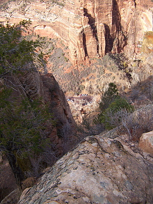
Steep hike to hidden slot by PaleoRob  Zion Canyon is a beautiful, unparalleled declivity in the earth's surface at the edge of the Colorado Plateau. Here the vast amount of sediment, laid down over millions of years, is exposed in one steep-walled gorge, cut by the Virgin River as it heads down to the lower elevations of the Great Basin, and eventually Lake Mead. In order to become so deep and steep, the Virgin River has to cut down through lots of sedimentary layers very fast. Represented within the park, being cut by the river, are the Navajo, Kayenta, Moenave, and Chinle Formations. Because this cutting happened so rapidly, many small tributary streams were literally left hanging as the Virgin sliced through the rocks at rocket (for a geological event) speeds. Hidden Canyon is one of these tributaries. From the parking area for Dripping Springs, the trail takes off to the south. To the east, against the cliff face, the alcove of Dripping Springs can be easily seen. Hike south, and cross the bridge spanning the creek flowing from the springs. The trail to Dripping Springs branches to the left, and the Hidden Canyon/Overlook/East Rim trail continues straight on. Not too far past the creek and bridge (~50 yards), there is a mound of dirt on the east side of the trail with an interpretive sign. Back in the early days of settlement around Zion Canyon, it seems logs were in short supply. Some enterprising (and slightly mad) person came up with the idea of a cable lift from the floor of the canyon to the rim, and back, to harvest the Ponderosa Pines that live along the rim. There are some harrowing pictures of the lift in operation on the sign, and apparently the lower terminus for the cable was there on that mound of dirt. Looking up towards the rim, the remains of the towers at the upper end are still visible.
Check out the Triplogs. Leave No Trace and +Add a Triplog after your canyon trip to support this local community. | ||||||||||||||||||||||||||||||||||||||||||||||||||||||||||||||||||||||||||||||||||||||||||