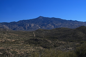
Hope Camp Trail is a nice easy walk along the southern flank of Tanque Verde Ridge and the Rincon Mountains along an old route to some old line camps, sites of round-ups when these were functioning ranchlands. There are two such camps along the way: Deer Camp and Hope Camp at the end of the line. Old rusty windmills and cement troughs mark these camps. There are lovely vista views along the way.
Take off from the parking lot and immediately pass through a hiker's gate. Immediately, there is a signed trail junction. Hope Camp Trail continues straight ahead, and Ridge View Trail breaks left. We'll do this later. Continue straight along the Hope Camp Trail. It's an easy grade with some minor ups and downs, and huge vistas to your left the whole way. Massive saguaros escort your passage. You will do a couple of wash crossings as you go. The route is always easy to follow.
At about 1.3 miles, you will come to the Deer Camp site. There are an old windmill and silo on your left, just across the wash. Periodically along the way, halfway up the south face of Tanque Verde Ridge, you see some grand dry falls. After a rain, these have to be sensational. From here, you do a nice easy climb to a saddle at 1.8 miles. From here, you have great views over Rincon Valley and Rincon Peak. Now there is a smooth descent through some riparian and grassy habitat to the old Hope Camp. Here are another old windmill and some cement troughs. The isolated feel of this old site is excellent. This is 2.8 miles from the trailhead.
There is another signed junction here. Take the North Hope trail from here across some beautiful desert grasslands for 0.3 miles. There is an old rickety fence to your right. There are fabulous views of Rincon Peak and Rincon Valley. The trail is littered with pricklies, cholla, and giant saguaros. It ends unceremoniously in a small loop at a little "trail closed" sign. You can see a small knoll straight ahead. A short quarter-mile bushwhack to this hilltop affords excellent views out over the Rincons.
After heading back on the North Hope Trail, then back the Hope Camp Trail to the original junction with the Ridge View Trail, hang a right and head north on this short 0.8-mile trail. This is a pleasant route lined with purple cholla and purple Santa Rita prickly pears. It winds and climbs mildly to a small saddle overlooking all of the Hope Camp trail, southern Tanque Verde Ridge, and Rincon Peak...wow, this is sweet! Head back the way you came to the trailhead.
Gate Policy: If a gate is closed upon arrival, leave it closed after you go through. If it is open, leave it open. Leaving a closed gate open may put cattle in danger. Closing an open gate may cut them off from water. Please be respectful, leave gates as found. The exception is signage on the gate directing you otherwise.
WARNING! Hiking and outdoor related sports can be dangerous. Be responsible and prepare for the trip. Study the area you are entering and plan accordingly. Dress for the current and unexpected weather changes. Take plenty of water. Never go alone. Make an itinerary with your plan(s), route(s), destination(s) and expected return time. Give your itinerary to trusted family and/or friends.
Permit $$
None
Saguaro National Park 2022 $25 vehicle • $20 motorcycle • $15 individual on foot or bicycle
Receipt is valid for 7 days
$45 Annual Park Pass View All
No fee required from Miller Creek Trailhead off Mescal Rd.
Directions
Road
Paved - Car Okay
To hike From Tucson, take I-10 East to exit # 279 (Wentworth/Vail Road). Go north on Vail road for 3 miles to the intersection with Camino Loma Alta. Take a left here and follow this road roughly 5.5 miles until it ends at the Loma Alta Trailhead. The last 0.5-0.75 miles is on a smooth gravel road.
2011-05-03 Guest writes: Vail road now ends in a T. Turn Right and go about 1/4 mile, and you find Camino Loma Alta
 Route Editor

 Hope Camp Trail is a nice easy walk along the southern flank of Tanque Verde Ridge and the Rincon Mountains along an old route to some old line camps, sites of round-ups when these were functioning ranchlands. There are two such camps along the way: Deer Camp and Hope Camp at the end of the line. Old rusty windmills and cement troughs mark these camps. There are lovely vista views along the way.