Route Editor

| Guide | ♦ | 29 Triplogs | 1 Topic |
details | drive | permit | forecast | route |
stats |
photos | triplogs | topic | location |
| 213 | 29 | 1 |
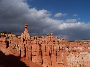
High-elevation hike through Bryce Amphitheater by PaleoRob The Peek-A-Boo Loop begins along the rim trail at Sunset Point, south of the northern campground. There is a shuttle bus stop and a parking area, along with a bathroom. There is seasonally a drinking fountain. There are signs directing visitors to the trailheads and the overlook. The Peek-A-Boo trailhead starts, sharing the trail with part of the Navajo Loop. It heads down into the amphitheater just north of the overlook.
The trail follows the wash bottom for a couple of hundred yards and then bends out of the wash to the south. The trail branches again at this point, with the Peek-A-Boo trail going straight. As you begin to climb the opposite canyon wall, the trail will branch again. This is where the two parts of the Peek-A-Boo loop come back together. I have only hiked the trail by heading right at this point and will describe it as such. The trail rises steeply in a series of switchbacks as it climbs a small mesa in the heart of Bryce Amphitheater. While the switchbacks are neither as steep nor as closely spaced as the ones heading down from the rim of the plateau, you still need to pace yourself climbing here, as the altitude is over 7000 feet. When you reach the rim of the small mesa, the rim of Bryce Amphitheater expands in front of you to the west studded with hoodoos. The trail also goes by several hoodoos on the mesa, as well as some strange and warped pine trees. Some ancient bristlecone pines live along this trail, as well as elsewhere in the park. Some of these are perched on the ridge to the east of the trail as you crest the ridge, in a pretty neat display of nature. The trail winds along the top of the mesa for a while, passing more spires and going through several tunnels carved through rock fins. The trail also crosses several small draws as it makes its way toward the southernmost point in the loop. Previously there was a trail that led from Bryce Point, on the south side of Bryce Amphitheater, down to the Peek-A-Boo trail, allowing the loop to be done from either end or a single-direction shuttle-hike. However, this trail is washed out, leaving only one option for continuing the hike. At the bottom of this trail, there was a restroom (that was closed in September when we were there), a water fountain (that was turned off in Sept. as well), and a horse corral (that was empty). This trail is used by both people and horseback riders. Please use caution, yield the right of way, and listen to the mule train leader if he gives directions. After taking a break at the horse corral (which is about midway through the hike), continue along, passing the bottom end of the washed-out Bryce Point trail, and begin climbing back up the small mesa. On this side of the mesa, you can look out onto the upper Paria River basin. You can also the Aquarius Plateau and the valley near the town of Tropic. On some bends of the trail, the rim by the trailhead can be seen, and more hoodoos sprinkle the views. Finally, you reach the point of the trail where the two sections meet back up. Proceed from here back to the trailhead via the trail you hiked in on.
Check out the Official Route and Triplogs. Leave No Trace and +Add a Triplog after your hike to support this local community. | ||||||||||||||||||||||||||||||||||||||||||||||||||||||||||||||||||||||||||||||||||||||||||||||||||||||||||||||||||||||||||||||||||||||||||||||||||||||||||||||||||||||||||||||||||||||||