Route Editor

| Guide | ♦ | 36 Triplogs | 0 Topics |
details | drive | permit | forecast | route |
stats |
photos | triplogs | topics | location |
| 196 | 36 | 0 |
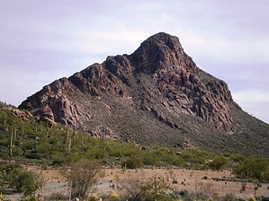
Climbing to the Center by PhilipMueller  Cat Mountain provides a stunning southern backdrop to an area of Tucson known as Starr Pass. At the southeastern edge of Tucson Mountain Park, it shoots out of the desert floor like Starr Pass' own Rock of Gibraltar. About a year ago, I incorporated Cat Mountain into a longer loop hike that started from a northern location in the Park, but this time around, I started the hike on the south-side base of the mountain. I'll include photographs from both hikes to provide a better overview of Cat Mt. Cat Mountain provides a stunning southern backdrop to an area of Tucson known as Starr Pass. At the southeastern edge of Tucson Mountain Park, it shoots out of the desert floor like Starr Pass' own Rock of Gibraltar. About a year ago, I incorporated Cat Mountain into a longer loop hike that started from a northern location in the Park, but this time around, I started the hike on the south-side base of the mountain. I'll include photographs from both hikes to provide a better overview of Cat Mt.From the trailhead on the south side, you walk north on a wide trail/old road toward a narrow gateway between Cat Mt. and a lower, mountain that continues along Cat Mt.'s line to the west. At about the 1/2 mile point, you will be between the two mountains and see two red posts, with boulders to their east at the western base of Cat Mt. From here, you can begin your ascent up Cat Mt. from a few yards south of the red posts or a few yards north. It doesn't matter; I've done it both ways. There is no real trail from this point forward. You'll see paths where others have scrambled, and near the top, you'll see some cairns here and there for suggested guidance, but you pretty much choose your own adventure. On this particular trip, I started on the south side of the posts.
Within a total of about an hour, you'll be at the top. You'll see a solar-powered police repeater hidden under a faux rock, about the size of a desk. A little sign on it claims that it is monitored by the Sheriff's department and that any damage to it will trigger an IMMEDIATE investigation by the Sheriff's helicopter... be careful where you sit! What you are up there to see, though, is 360 degrees of views of Tucson, its mountain ranges, and beyond. What a treat to look SW to see Babo and Kitt, SE to see Wrightson, E to see the Rincons, N to see the Catalinas, NW to see the Tortolitas, and W into more of the Tucson Mountains. We each define our own "centers", and for me, this was like being in the "center", looking from the sky at the city that I call home and the majestic nature that surrounds it--a center point from which to reflect upon the memories I have had here and to ponder the adventures yet to come. Just choosing the route up would be up to you, the way down is also open to whatever you want to do and are capable of doing. Scrambling up and down Cat takes a total of about 2 hours. You gain about 1,200 feet in about 1.3 miles, so it's short but has a pretty nice rise over run. I used my hands a lot, and I'd recommend gloves. It's not a lush scramble, but you'll see a nice sampling of Sonoran Desert plants along the ascent. In getting there, if you have the time, enjoy the beautiful drive that starts when Speedway west of I-10 turns into West Gates Pass Boulevard. The winding drive from there, through Gates Pass, and then back around toward Cat Mountain on Kinney Road offers views of several mountains and close-ups of the Sonoran Desert. (It's quite fun on a motorcycle, too!). Enjoy! Gate Policy: If a gate is closed upon arrival, leave it closed after you go through. If it is open, leave it open. Leaving a closed gate open may put cattle in danger. Closing an open gate may cut them off from water. Please be respectful, leave gates as found. The exception is signage on the gate directing you otherwise.
Check out the Official Route and Triplogs. Leave No Trace and +Add a Triplog after your hike to support this local community. | |||||||||||||||||||||||||||||||||||||||||||||||||||||||||||||||||||||||||||||||||||||